Minories
Minories (/ˈmɪnəriːz/, not /ˈmaɪnəriːz/) is the name of a former civil parish, also known as Minories Holy Trinity, and a street in the City of London, close to the Tower of London.
Toponymy
Minories' name is derived from the former Abbey of the Minoresses of St Mary of the Order of St Clare, founded in 1294. A "minoress" was a nun in the Second Order of the Order of Friars Minor known as Franciscans. A small side-road off Minories is named St. Clare Street. The name can be found in other English towns including Birmingham, Colchester, Newcastle upon Tyne and Stratford-upon-Avon.
Romans
In September 2013, a well preserved Roman statue of an eagle, thought to have been part of a funerary monument, was discovered on a building site on the street. The statue is considered to be one of the best examples of Romano-British sculpture in existence.[1]
Governance
Minories was in the ancient parish of St Botolph without Aldgate until 1557, when it became extra-parochial.[2]
The area was a papal peculiar outside the jurisdiction of the English bishops. The abbey was dissolved in 1539 when the property passed to the Crown. The chapel of the former abbey became the Church of Holy Trinity, Minories, and other buildings were used as an armoury and later as a workhouse. In 1686, the area became part of the Liberties of the Tower of London. The Minories area historically hosted a large Jewish community.[3]
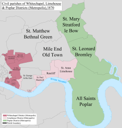
Minories Holy Trinity was abolished as a civil parish in 1895 and absorbed into the parish of Whitechapel.
Minories railway station
The street gave its name to Minories railway station, built in 1840 as a part of the London and Blackwall Railway – a 3.5-mile (5.6 km) cable railway. The site is now occupied by the Docklands Light Railway (DLR) station, Tower Gateway which opened in 1989 as the system's western terminus. The DLR was extended westward in 1991 to Bank leaving it as an 'alternate terminus'. It reopened following platform extension work in 2009.
Geography
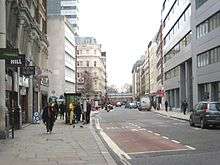
The modern street named Minories runs north-south with traffic flowing both-ways from Aldgate to Tower Hill;[4] it is part of the A1211 road between the Barbican and Whitechapel. The border between the City and the London Borough of Tower Hamlets ran haphazardly between Minories and nearby Mansell Street until boundary changes in 1994 relocated the present-day border along Mansell Street, so that Minories is now within the City of London. Aldgate Underground station is at the northern end of Minories, on Aldgate High Street.
References
Sources
- Pennant, Thomas (1816). Some Account of London. London: J Faulder (digital edition from New York Public Library, 2007). p. 372.
- Thornbury, Walter (1878). Old and New London: Volume 2. London: Cassel (digital edition from University of London & History of Parliament Trust, 2007). pp. 245–250.
| Wards |  | |
|---|---|---|
| Enclaves | ||
| Localities | ||
| Attractions |
| |
| Notable structures | ||
| Civil parishes | ||
| Bridges | ||
| Rail and tube stations | ||
| Topics | ||
| ||
Coordinates: 51°30′39″N 0°04′30″W / 51.5108°N 0.0751°W