Prairie View, Arkansas
| Prairie View, Arkansas | |
|---|---|
| Unincorporated community | |
 Prairie View, Arkansas  Prairie View, Arkansas | |
| Coordinates: 35°20′04″N 93°31′05″W / 35.33444°N 93.51806°WCoordinates: 35°20′04″N 93°31′05″W / 35.33444°N 93.51806°W | |
| Country | United States |
| State | Arkansas |
| County | Logan |
| Elevation | 423 ft (129 m) |
| Time zone | Central (CST) (UTC-6) |
| • Summer (DST) | CDT (UTC-5) |
| Area code(s) | 479 |
| GNIS feature ID | 78094[1] |
Prairie View is an unincorporated community in Logan County, Arkansas, United States. Prairie View is located at the junction of Arkansas Highway 109 and Arkansas Highway 288 2 miles (3.2 km) south-southeast of Scranton.[2]
References
- ↑ U.S. Geological Survey Geographic Names Information System: Prairie View, Arkansas
- ↑ Logan County, Arkansas General Highway Map (PDF) (Map). Arkansas State Highway and Transportation Department. 2002. Retrieved 2011-05-08.
Municipalities and communities of Logan County, Arkansas, United States | ||
|---|---|---|
| Cities | 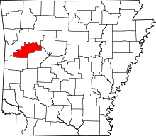 | |
| Towns | ||
| CDP | ||
| Unincorporated communities | ||
This article is issued from Wikipedia - version of the 7/29/2016. The text is available under the Creative Commons Attribution/Share Alike but additional terms may apply for the media files.