Bagrationovsk
| Bagrationovsk (English) Багратионовск (Russian) | |
|---|---|
| - Town[1] - | |
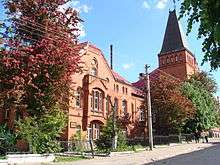
..JPG) Remains of the Preußisch Eylau Castle | |
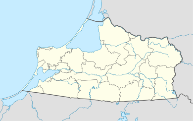
.svg.png) Location of Kaliningrad Oblast in Russia | |
 Bagrationovsk | |
|
| |
.png) | |
|
| |
| Administrative status (as of November 2011) | |
| Country | Russia |
| Federal subject | Kaliningrad Oblast[1] |
| Administrative district | Bagrationovsky District[1] |
| Town of district significance | Bagrationovsk[1] |
| Administrative center of | Bagrationovsky District,[1] town of district significance of Bagrationovsk[1] |
| Municipal status (as of April 2010) | |
| Municipal district | Bagrationovsky Municipal District[2] |
| Urban settlement | Bagrationovskoye Urban Settlement[2] |
| Administrative center of | Bagrationovsky Municipal District,[2] Bagrationovskoye Urban Settlement[2] |
| Statistics | |
| Population (2010 Census) | 6,400 inhabitants[3] |
| Time zone | USZ1 (UTC+02:00)[4] |
| Founded | 1336[5] |
| Town status since | 1585[6] |
| Previous names |
Preußisch Eylau (until 1945),[5] Preysish Eylau (until 1946)[5] |
| Postal code(s)[7] | 238420 |
|
| |
| Bagrationovsk on Wikimedia Commons | |
Bagrationovsk (Russian: Багратио́новск), before 1946 known by its German name Preußisch Eylau (Lithuanian: Ylava or Prūsų Ylava; Polish: Pruska Iława or Iławka) is a town and the administrative center of Bagrationovsky District in Kaliningrad Oblast, Russia, located 37 kilometers (23 mi) south of Kaliningrad, the administrative center of the oblast. Population: 6,400 (2010 Census).[3]
History
![]() Teutonic Order 1325–1466
Teutonic Order 1325–1466
![]() Teutonic Order 1466–1525 (fief of Poland)
Teutonic Order 1466–1525 (fief of Poland)
![]() Duchy of Prussia 1525–1657 (fief of Poland)
Duchy of Prussia 1525–1657 (fief of Poland)
![]() Duchy of Prussia 1657–1701
Duchy of Prussia 1657–1701
![]() Kingdom of Prussia 1701–1871
Kingdom of Prussia 1701–1871
![]() German Empire 1871–1918
German Empire 1871–1918
![]() Weimar Republic 1918–1933
Weimar Republic 1918–1933
![]() Nazi Germany 1933–1945
Nazi Germany 1933–1945
![]() Polish People's Republic 1945
Polish People's Republic 1945
![]() Soviet Union 1945–1991
Soviet Union 1945–1991
![]() Russian Federation 1991-present
Russian Federation 1991-present
In 1325, the Teutonic Knights built a Ordensburg castle called "Yladia"[6] or "Ilaw", later known as "Preussisch Eylau", in the center of the Old Prussian region Natangia. 'Ylow' is the Old Prussian term for 'mud' or 'swamp'. The settlement nearby developed in 1336,[5] but in 1348 the Teutonic Order gave the privilege to establish twelve pubs in the area around the castle. Although the settlement had only a few inhabitants, due to its central position it was often used as meeting place for officials of the Order. During the Thirteen Years' War, the castle was besieged on 24 May 1455 by troops of the Prussian Confederation under the command of Remschel von Krixen, but the garrison defeated these troops. During the Horsemen's War in 1520, the castle was unsuccessfully besieged by troops of the Polish Kingdom, which devastated the settlement.
Preußisch Eylau received its civic charter in 1585.[6] In 1709–1711, the bubonic plague killed 2,212 inhabitants of the Eylau area.
The bloody Battle of Eylau (7–8 February 1807) during the Napoleonic Wars involved the French troops of Napoleon Bonaparte, the Russian troops of General Bennigsen, and the Prussian troops of General Anton Wilhelm von L'Estocq. Only 3 inhabitants of Eylau died in the battle, but 605 persons died due to hunger and diseases in 1807 (with the average death rate in "normal" years being around 80-90). Napoleon used the local courthouse as his headquarters in Eylau on 7–17 February 1807.
On 1 April 1819, the town became the seat of the administrative district Preußisch Eylau (Kreis Pr. Eylau). In 1834, a Teachers' Seminary was founded, educating every East Prussian teacher until it was closed down in 1924. The town was connected to the railway on 2 September 1866. The town was occupied without a struggle by Russian troops on 27 August 1914, but these troops left on 3 September 1914.
After 1933, large barracks were built by the Wehrmacht, and in 1935 Infantry and Artillery units were stationed there.
On February 10, 1945,[5] during the Soviet Red Army's East Prussian Offensive, the town was occupied by troops of the 55th Guards "Irkutsk-Pinsk" Division commanded by Major General Adam Turchinsky. The German population that had not already fled during the evacuation of East Prussia was subsequently expelled, with the last transport leaving on November 23, 1947. The NKVD established a prison camp for German civilians inside the former Wehrmacht barracks in 1945-1949. It held an estimated 13,000 inmates, of whom some 6,000 people died.[6]
In early August 1945, Polish officials took over the administrative power in the town, but left again on January 1, 1946, as the new borderline between the Soviet Union and Poland was set just at the southern outskirts of the town. The Polish administrative area south of the border was called "Powiat Ilawka" until 1958.
In January 1946, the town became a part of the newly established Kaliningrad Oblast within the Russian SFSR and the town was given its present name, honoring General Pyotr Bagration, who was one of the senior Russian leaders in the Napoleonic Wars.
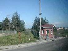
Today the main border crossing point between Russia and Poland (Bezledy/Bagrationovsk) is 2 kilometers (1.2 mi) south of the town. Since April 2007, government restrictions on visits to border areas have been tightened and travel to Sovetsk and Bagrationovsk is only allowed with special permission, unless in transit.[8]
Administrative and municipal status
Within the framework of administrative divisions, Bagrationovsk serves as the administrative center of Bagrationovsky District.[1] As an administrative division, it is incorporated within Bagrationovsky District as the town of district significance of Bagrationovsk.[1] As a municipal division, the town of district significance of Bagrationovsk is incorporated within Bagrationovsky Municipal District as Bagrationovskoye Urban Settlement.[2]
Population
- 1782: 1,453
- 1804: 1,816
- 1820: 1,631
- 1846: 2,630
- 1852: 2,988
- 1871: 3,719
- 1885: 3,547
- 1890: 3,446 (including 42 Catholics, 42 Jews)
- 1900: 3,248
- 1910: 3,270
- 1925: 3,787
- 1933: 4,123
- 1939: 7,485 (including 1,185 military personnel)
- 1946: 2,275 (including 1,339 Germans )
- 1968: 4,300
- 1989 Census: 6,728[9]
- 2002 Census: 7,216[10]
- 2010 Census: 6,400[3]
Notable people
- Hugo Falkenheim (1856–1945), medical doctor and last Chairman of the Jewish parish of Königsberg
- Konrad Theodor Preuss (1869–1938), ethnologist
- Robert Kudicke (1876-1961), medical officer and tropical medicine, university lecturer in Guangdong and Frankfurt am Main
Twin towns and sister cities
Bagrationovsk is twinned with:
 Verden an der Aller, Lower Saxony, Germany
 Górowo Iławeckie, Poland
- Bartoszyce, Poland
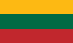 Jonava, Lithuania
References
Notes
- 1 2 3 4 5 6 7 8 Resolution #640
- 1 2 3 4 5 Law #253
- 1 2 3 Russian Federal State Statistics Service (2011). "Всероссийская перепись населения 2010 года. Том 1" [2010 All-Russian Population Census, vol. 1]. Всероссийская перепись населения 2010 года (2010 All-Russia Population Census) (in Russian). Federal State Statistics Service. Retrieved June 29, 2012.
- ↑ Правительство Российской Федерации. Федеральный закон №107-ФЗ от 3 июня 2011 г. «Об исчислении времени», в ред. Федерального закона №271-ФЗ от 03 июля 2016 г. «О внесении изменений в Федеральный закон "Об исчислении времени"». Вступил в силу по истечении шестидесяти дней после дня официального опубликования (6 августа 2011 г.). Опубликован: "Российская газета", №120, 6 июня 2011 г. (Government of the Russian Federation. Federal Law #107-FZ of June 31, 2011 On Calculating Time, as amended by the Federal Law #271-FZ of July 03, 2016 On Amending Federal Law "On Calculating Time". Effective as of after sixty days following the day of the official publication.).
- 1 2 3 4 5 Энциклопедия Города России. Moscow: Большая Российская Энциклопедия. 2003. p. 32. ISBN 5-7107-7399-9.
- 1 2 3 4 Schulz 1998
- ↑ Почта России. Информационно-вычислительный центр ОАСУ РПО. (Russian Post). Поиск объектов почтовой связи (Postal Objects Search) (Russian)
- ↑ http://www.gwu.edu/~ieresgwu/assets/docs/pepm_016.pdf
- ↑ Demoscope Weekly (1989). "Всесоюзная перепись населения 1989 г. Численность наличного населения союзных и автономных республик, автономных областей и округов, краёв, областей, районов, городских поселений и сёл-райцентров" [All Union Population Census of 1989: Present Population of Union and Autonomous Republics, Autonomous Oblasts and Okrugs, Krais, Oblasts, Districts, Urban Settlements, and Villages Serving as District Administrative Centers]. Всесоюзная перепись населения 1989 года [All-Union Population Census of 1989] (in Russian). Институт демографии Национального исследовательского университета: Высшая школа экономики [Institute of Demography at the National Research University: Higher School of Economics]. Retrieved August 9, 2014.
- ↑ Russian Federal State Statistics Service (May 21, 2004). "Численность населения России, субъектов Российской Федерации в составе федеральных округов, районов, городских поселений, сельских населённых пунктов – районных центров и сельских населённых пунктов с населением 3 тысячи и более человек" [Population of Russia, Its Federal Districts, Federal Subjects, Districts, Urban Localities, Rural Localities—Administrative Centers, and Rural Localities with Population of Over 3,000] (XLS). Всероссийская перепись населения 2002 года [All-Russia Population Census of 2002] (in Russian). Retrieved August 9, 2014.
Sources
- Правительство Калининградской области. Постановление №640 от 30 августа 2011 г. «Об утверждении реестра объектов административно-территориального деления Калининградской области», в ред. Постановления №877 от 21 ноября 2011 г «О внесении изменения в Постановление Правительства Калининградской области от 30 августа 2011 г. №640». Вступил в силу со дня официального опубликования. Опубликован: "Калининградская правда" (вкладыш "Официально"), №170, 15 сентября 2011 г. (Government of Kaliningrad Oblast. Resolution #640 of August 30, 2011 On the Adoption of the Registry of the Objects of the Administrative-Territorial Divisions of Kaliningrad Oblast, as amended by the Resolution #877 of November 21, 2011 On Amending the Resolution of the Government of Kaliningrad Oblast #640 of August 30, 2011. Effective as of the day of the official publication.).
- Калининградская областная Дума. Закон №253 от 30 июня 2008 г. «Об организации местного самоуправления на территории муниципального образования "Багратионовский городской округ"», в ред. Закона №428 от 12 апреля 2010 г «Об изменении границ муниципальных образований». Вступил в силу со дня официального опубликования. Опубликован: "Калининградская правда", №124, 11 июля 2008 г. (Kaliningrad Oblast Duma. Law #253 of June 30, 2008 On the Organization of the Local Self-Government on the Territory of the Municipal Formation of "Bagrationovsky Urban Okrug", as amended by the Law #428 of April 12, 2010 On Changing the Borders of the Municipal Formations. Effective as of the day of the official publication.).
- Horst Schulz. Preußisch Eylau — eine Kreisstadt in Ostpreußen. Lübeck, 1998
- Horst Schulz. Der Kreis Preußisch Eylau. Verden, 1983
- Wolf, Dr. Horst. Ich sage die Wahrheit oder ich schweige. Leer, 1983
Administrative divisions of Kaliningrad Oblast (former German names are given in parentheses and italicized) | ||
|---|---|---|
Administrative center: Kaliningrad (Königsberg) | ||
| Cities and towns |
| |
| Urban-type settlements of oblast significance |
| |
| Districts | ||