Princeton Center Historic District
|
Princeton Center Historic District | |
|
Princeton Public Library | |
  | |
| Location | Princeton, Massachusetts |
|---|---|
| Coordinates | 42°26′57″N 71°52′43″W / 42.44917°N 71.87861°WCoordinates: 42°26′57″N 71°52′43″W / 42.44917°N 71.87861°W |
| Area | 165 acres (67 ha) |
| Built | 1885 |
| Architect | Earle, Stephen C.; Norcross Bros. |
| Architectural style | Romanesque Revival |
| NRHP Reference # |
[1] (original) 06000130 (increase) |
| Significant dates | |
| Added to NRHP | February 26, 1999 |
| Boundary increase | March 10, 2006 |
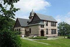
The Princeton Center Historic District is a historic district encompassing the 19th century center of Princeton, Massachusetts. The district is centered at the junction of Hubbardston and Mountain Roads, and includes the town common, town hall, public library, and First Congregational Church. When first listed on the National Register of Historic Places in 1999, the district encompassed 11 acres (4.5 ha), and included only the common, town hall, and library;[2] it was expanded in 2006 to 165 acres (67 ha), and included much of the village of Princeton Center.[3]
See also
- Russell Corner Historic District
- West Village Historic District (Princeton, Massachusetts)
- East Princeton Village Historic District
- National Register of Historic Places listings in Worcester County, Massachusetts
References
- ↑ National Park Service (2008-04-15). "National Register Information System". National Register of Historic Places. National Park Service.
- ↑ "NRHP nomination for Princeton Center Historic District". Commonwealth of Massachusetts. Retrieved 2014-03-20.
- ↑ "NRHP nomination for Princeton Center Historic District (2006 increase)". Commonwealth of Massachusetts. Retrieved 2014-03-20.
| Topics |  | ||||||||||||||||||||||||||||||
|---|---|---|---|---|---|---|---|---|---|---|---|---|---|---|---|---|---|---|---|---|---|---|---|---|---|---|---|---|---|---|---|
| Lists by county | |||||||||||||||||||||||||||||||
| Lists by city |
| ||||||||||||||||||||||||||||||
| Other lists | |||||||||||||||||||||||||||||||
| |||||||||||||||||||||||||||||||
This article is issued from Wikipedia - version of the 11/27/2016. The text is available under the Creative Commons Attribution/Share Alike but additional terms may apply for the media files.