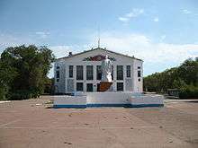
Priozersk, Kazakhstan
| Priozersk Приозёрск | |
|---|---|
| closed city | |
 Priozersk Location in Karagandy Province, Kazakhstan | |
| Coordinates: 46°01′51″N 73°42′07″E / 46.03083°N 73.70194°ECoordinates: 46°01′51″N 73°42′07″E / 46.03083°N 73.70194°E | |
| Country | Kazakhstan |
| Region | Karaganda Region |
| Founded | 1956 |
| Area | |
| • Total | 54.5 km2 (21.0 sq mi) |
| Population (2009) | |
| • Total | 13,479 |
| Postal code | 101100 |
| Area code(s) | +7 71039 |
Priozersk (Kazakh: Приозёрск, Priozyorsk; Russian: Приозёрск, Priozyorsk) is a closed city at Lake Balkhash, Kazakhstan. It serves as the administrative center of Sary Shagan anti-ballistic missile testing site.
Priozersk is located in Karaganda Region (central Kazakhstan), approximately 620 kilometers to the south-east of the Karaganda and 747 kilometers from Astana. The Cambala Airport lies in the suburbs.
Population: 13,479 (2009 Census results);[1] 11,033 (1999 Census results).[1] By nationality, the city is 46% Russian, 39% Kazakh, 6% Ukrainian, and 9% other. The town is closed for visiting by foreign citizens.
History
Tens of thousands of workers and hundreds of missile experts and army officers arrived after the Soviet government decided to establish a secret military base in the Kazakh Steppe. This testing site for the soviet missile defense system was one of such centers, which had led to construction of anti-ballistic missiles and to attain parity in the arms race between the USSR and United States.
After the Soviet Union collapse, the Russian Federation agreed with Kazakhstan to lease some military units for 50 years. The Russian Army continues to use the base at Priozersk as the testing site for improving anti-ballistic and anti-aircraft defense systems.
Climate
Köppen-Geiger climate classification system classifies its climate as humid continental (Dfa).
| Climate data for Priozersk | |||||||||||||
|---|---|---|---|---|---|---|---|---|---|---|---|---|---|
| Month | Jan | Feb | Mar | Apr | May | Jun | Jul | Aug | Sep | Oct | Nov | Dec | Year |
| Average high °C (°F) | −2 (28) |
0 (32) |
7 (45) |
16 (61) |
22 (72) |
26 (79) |
30 (86) |
29 (84) |
23 (73) |
16 (61) |
6 (43) |
1 (34) |
14.5 (58.2) |
| Daily mean °C (°F) | −7 (19) |
−5 (23) |
2 (36) |
11 (52) |
17 (63) |
21 (70) |
24 (75) |
22.5 (72.5) |
17 (63) |
10 (50) |
1 (34) |
−4.5 (23.9) |
9.08 (48.45) |
| Average low °C (°F) | −12 (10) |
−10 (14) |
−3 (27) |
5 (41) |
11 (52) |
15 (59) |
17 (63) |
16 (61) |
11 (52) |
4 (39) |
−4 (25) |
−10 (14) |
3.3 (38.1) |
| Average precipitation mm (inches) | 26 (1.02) |
32 (1.26) |
64 (2.52) |
89 (3.5) |
99 (3.9) |
59 (2.32) |
35 (1.38) |
23 (0.91) |
25 (0.98) |
46 (1.81) |
48 (1.89) |
32 (1.26) |
578 (22.75) |
| Average precipitation days (≥ 0.1 mm) | 9 | 9 | 12 | 11 | 12 | 10 | 9 | 6 | 5 | 7 | 10 | 9 | 109 |
| Average relative humidity (%) | 74 | 74 | 73 | 59 | 55 | 51 | 45 | 44 | 45 | 55 | 70 | 74 | 59.9 |
| Mean daily sunshine hours | 3.7 | 4.2 | 4.5 | 6.5 | 7.8 | 9.4 | 10.2 | 9.5 | 8.3 | 6.4 | 4.3 | 3.6 | 6.53 |
| Source: climatemps.com[2] | |||||||||||||
References
- 1 2 "Население Республики Казахстан" (in Russian). Департамент социальной и демографической статистики. Retrieved 8 December 2013.
- ↑ "Kazakhstan Climate, Average Weather, Temperatures, Rainfall, Sunshine, Humidity, Graphs". climatemps.com. Retrieved 2 September 2013.
External links
-
 Media related to Priozyorsk (Kazakhstan) at Wikimedia Commons
 - Official site of city administration
- Priozersk community site
Capital: Karaganda | ||
| Districts |  | |
| Major cities | ||