Project Rio Blanco
Project Rio Blanco
 Rio Blanco Test Site | |
|---|---|
| Information | |
| Country | United States |
| Test series |
Operation Toggle Operation Plowshare |
| Test site | Rio Blanco Site, 39°47′34.8″N 108°22′4.8″W / 39.793000°N 108.368000°WCoordinates: 39°47′34.8″N 108°22′4.8″W / 39.793000°N 108.368000°W[1] |
| Date | May 17, 1973 |
| Test type | Underground |
| Yield | 3x 33 kt |
Project Rio Blanco was an underground nuclear test that took place on May 17, 1973 in Rio Blanco County, Colorado, approximately 36 miles (58 km) northwest of Rifle.[2]
Three 33-kiloton nuclear devices were detonated nearly simultaneously in a single emplacement well at depths of 1,779, 1,899 and 2,039 m below ground level. The tests were conducted in fine-grain, low-permeability sandstone lenses at the base of the Fort Union Formation and the upper portion of the Mesaverde Formation.
This was the third and final natural-gas-reservoir stimulation test in the Plowshare program, which was designed to develop peaceful uses for nuclear energy. The two previous tests were Project Gasbuggy in New Mexico and Project Rulison in Colorado.
The United States Atomic Energy Commission conducted the test in partnership with CER Geonuclear Corporation and Continental Oil Company.
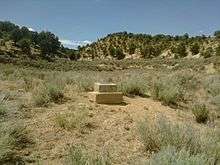
A placard, erected in 1976, now marks the site where the test was conducted. The site is accessible via a dirt road, Rio Blanco County Route 29.
References
| Wikimedia Commons has media related to Toggle Rio Blanco. |
- ↑ United States Nuclear Tests, July 1945 through September 1992, DOE/NV--209-REV 15, December 2000
- ↑ Rio Blanco Site Fact Sheet, DOE Office of Legacy Management
![]() This article incorporates public domain material from websites or documents of the United States Department of Energy.
This article incorporates public domain material from websites or documents of the United States Department of Energy.