Province of Mantua
| Province of Mantua | |
|---|---|
| Province | |
|
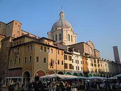
Palazzo della Cervetta in Mantua, the provincial seat. | |
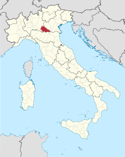 Map highlighting the location of the province of Mantua in Italy | |
| Country |
|
| Region | Lombardy |
| Capital(s) | Mantua |
| Comuni | 70 |
| Government | |
| • President | Alessandro Pastacci (PD) |
| Area | |
| • Total | 2,339 km2 (903 sq mi) |
| Population (31 May 2015) | |
| • Total | 413,663 |
| • Density | 180/km2 (460/sq mi) |
| Time zone | CET (UTC+1) |
| • Summer (DST) | CEST (UTC+2) |
| Vehicle registration | MN |
| ISTAT | 020 |
The Province of Mantua (Italian: Provincia di Mantova) is a province in the Lombardy region of northern Italy. Its capital is the city of Mantua. It is bordered to the north-east by the Province of Verona, to the east by that of Rovigo, to the south by those of Ferrara, Modena, Reggio Emilia and Parma, to the west by the Province of Cremona and to the north-west by that Brescia.
History
Founded in the tenth century BC on the plain formed by meanders of the River Mincio, Mantua became an Etruscan town and important trading post for pottery and agricultural products. Despite its defensible position, it was unable to withstand the Celtic invaders in the sixth and fifth centuries BC who overwhelmed it, and the whole area was later conquered by the Romans.[1]
By the fifth century AD, the Western Roman Empire was collapsing. Mantua was overrun by a series of invaders, including the Visigoths, Vandals, and Ostrogoths. After 568 the Lombards seized control of the part of northern Italy which is now known as Lombardy and included Mantua.[1]
The current administrative boundaries of the province have deep historical roots, corresponding largely to the Duchy of Mantua, which was a sovereign state under international law. The Napoleonic Department of the Mincio became the Province of Mantua at the birth of the Kingdom of Lombardy–Venetia in 1815. Following the Battle of Solferino on 24 June 1859, Franco-Piedmontese troops conquered Lombardy up to the right bank of the Mincio, and the resulting Armistice of Villafranca of 11 June 1859 between France and Austria called for the new provincial boundaries, splitting in two the part of the previous Province of Mantova that was crossed by the new international border. The new provincial boundaries came into effect after laws enacted in 1868. The coat of arms of the province, containing the symbols of Mantua, Bozzolo and Castiglione delle Stiviere, embodies the union of those three areas and was adopted in place of the previous one.
Geography
The Province of Mantua is bounded by several rivers. To the west, the River Oglio provides the border with the Province of Cremona. To the south it is bounded by the River Po, on the other side of which are the provinces of Ferrara, Modena, Reggio Emilia and Parma. To the east the River Mincio provides the border with the Province of Verona and the Province of Rovigo, and to the northwest lies the Province of Brescia. The total area of the province is 2,340 square kilometres (900 sq mi).[2] The River Po is subject to flooding and much of the bank is raised by levees.
Protected areas
There are a number of nature reserves and protected areas in the province. The Parco regionale del Mincio was established on the 8th September 1984 with an area of approximately 16,000 hectares. It includes several nature reserves and has a range of habitats including moraines, hills, plains, and the meandering riverbeds in the complex of lakes of Mantua. Birds found in the park include storks, herons, purple herons, egrets, night herons, kingfishers, bee-eaters, coots, moorhens, peregrine falcons, hawks, great crested grebe and black kite.
The Parco dell'Oglio Sud is another regional park that lies on the boundary of the province with the province of Cremona. It was established in 1988 and has an area of about 12,800 hectares. It is a river park that runs along the stretch of the river Oglio which forms the boundary. It lies to the south of Lake Iseo and the administrative centre is at Calvatone. Birds present in this park include great egret, grey heron, Montagu's harrier, Eurasian scops owl, bearded reedling, woodcock, barred warbler, crested lark, sedge warbler, moustached warbler, little egret, Eurasian hobby and ferruginous duck.
The Riserva naturale Bosco Fontana is a state nature reserve with an area of about 23,300 hectares. It is a wooded area that is a remnant of the natural forests that covered the Po valley in ancient times. It is a dense marshy forest composed mainly of Turkey oaks, pedunculate oaks, hornbeams, limes, poplars, elms and alders, which are accompanied by numerous species of shrubby undergrowth. There are glades with abundant wildflowers and fungi flourish among the trees, an important factor being the richness of the groundwater. Among the mammals found in the reserve are the least weasel, beech marten and European polecat, and the birds include the common buzzard, the great spotted woodpecker and the Eurasian wryneck.[3]
Economy
Despite Mantuan landscape is primarily an agricultural one and the primary sector accounted for the 6% of local GDP in 2003, much above Italian average, the province has an historically strong industrial sector, which accounts for 37% of the GDP, while the tertiary sector holds the remaining 56%.[4] Overall, the gross domestic product of the province was estimated in 2003 at over €10 billion.[4]
The productivity of agriculture is enhanced by a well-developed use of fertilizers and the traditional abundance of water. It is largely flat and the soil is very fertile and is intensively irrigated, boosted since the Middle Ages by the construction of a wide net of irrigation canals which were partly designed by Leonardo da Vinci. Crops grown include wheat, maize, rice, sugar beet, potatoes and vegetables. Olives, grapes, chestnuts and many other sorts of fruit are grown; mulberry plants are grown for their contribution to silk production, or sericulture. The lower plains are characterized by fodder crops, which are mowed up to eight times a year. Cattle are also bred and cheese and other dairy products are manufactured. The main exports from the province include cereals, rice, cheese and silk, but most industrial goods need to be imported.[5]
See also
References
- 1 2 Ring, Trudy; Watson, Noelle; Schellinger, Paul (2013). Southern Europe: International Dictionary of Historic Places. Taylor & Francis. pp. 416–. ISBN 978-1-134-25965-6.
- ↑ The Times Comprehensive Atlas of the World (13 ed.). Times Books. 2011. p. 76. ISBN 9780007419135.
- ↑ "Riserva Statale Bosco Fontana". Corpo Forestale dello Stato. Retrieved 18 October 2015.
- 1 2 (Italian) Struttura economica della provincia di Mantova
- ↑ Comprehensive Dictionary of the World. Mittal Publications. 1992. p. 613. GGKEY:RC6C27C4NE1.
External links
- Official website (Italian)
| Provinces and places | 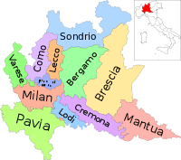 | |
|---|---|---|
| History | ||
| Politics and government | ||
| Education and culture | ||
Categories | ||
Coordinates: 44°54′N 12°30′E / 44.900°N 12.500°E