Province of Palencia
| Palencia | |||
|---|---|---|---|
| Province | |||
 | |||
| |||
 Map of Spain with Palencia highlighted | |||
| Country | Spain | ||
| Autonomous community |
| ||
| Capital | Palencia | ||
| Area | |||
| • Total | 8,052 km2 (3,109 sq mi) | ||
| Area rank | Ranked 29 | ||
| 1.6% of Spain | |||
| Population (2010) | |||
| • Total | 172,510 | ||
| • Rank | Ranked 46th | ||
| • Density | 21/km2 (55/sq mi) | ||
| Official language(s) | Spanish | ||
| Parliament | Cortes Generales | ||
| Website | Diputación de Palencia (Spanish) | ||


Palencia is a province of northern Spain, in the northern part of the autonomous community of Castile and León in the northeast of the Iberian Peninsula. It is bordered by the provinces of León, Cantabria, Burgos, and Valladolid.
Overview
Of the population of 176,125 (2002), 45% live in the capital, Palencia which is located on the Castilla Canal. There are 191 municipalities in the province, of which more than half are villages with fewer than 200 people. The major towns in this province are: Guardo, an industrial-mining town;[1] Aguilar de Campoo, a biscuit and tourist village in northern Palencia; Herrera de Pisuerga, a village that is the doors to the Palencine mountain, is also known for its summer activities and Crab Festival; Venta de Baños, an important railway and industrial junction south of the province; Villamuriel de Cerrato, a village to the south of Palencia that owes its development to the Renault factory[2] and its proximity to Palencia; Cervera de Pisuerga, in the heart of the Palencine mountains; Barruelo, a mining town[3] that was the most populated town until the 1960s. During the Middle Ages, the Visigoths ruled Palencia. Basílica de San Juan, the oldest Visigothic church in Spain, was built in 661 in the province's Baños de Cerrato.[4] During the thirteenth century a university was founded in the province. It was the first university in Spain and one of the first in the world. It was later shifted to Valladolid.[5]
The province is bordered on the north by Cantabria, on the west by the province of León, on the east by the province of Burgos and on the south by the province of Valladolid.
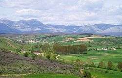
In Palencia large protected areas such as the Natural Park of Fuentes Carrionas and Fuente Cobre-Montaña Palencia are located.[6] The term historical region in Palencia, refers to those regions created in the fourteenth century, under the name merindades. Cantabrian Mountains are located in the northerns parts of the province. The 8,268 feet (2,520 metres) high Curavacas peak is located in the province.[7] The major commercial products produced in the province are barley, wheat, sugar beets, hemp, linen and woolen clothes, porcelain, leather, paper, and rugs. Food processing and metallurgy are major industries.[7] The province has three judicial districts–one each in Palencia, Carrión de los Condes and Cervera de Pisuerga.[8]
See also
References
- ↑ Wagner, Robert Herman; García, L. G. Fernández; Eager, R. M. C. (1983). Geology and Palaeontology of the Guardo Coalfield (NE Leon - NW Palencia), Cantabrian Mts. IGME. p. 7. ISBN 978-84-7474-220-6.
- ↑ Bank of London & South America (1976). Bank of London & South America Review. 10. Lloyds Bank International. p. 417.
- ↑ Cameron, Rondo E. (2000). France and the Economic Development of Europe, 1800-1914. Psychology Press. p. 91. ISBN 978-0-415-19011-4.
- ↑ Planet, Lonely (2012). Lonely Planet Valencia: Chapter from Spain Travel Guide. Lonely Planet Publications. p. 145. ISBN 978-1-74321-263-9.
- ↑ Devine, Mary Elizabeth; Summerfield, Carol (2013), International Dictionary of University Histories, Taylor & Francis, p. 109, ISBN 978-1-134-26217-5
- ↑ García, Carmelo Conesa; Guevara, Juan Bautista Martínez; Rogel, Yolanda Álvarez (2004), Medio ambiente, recursos y riesgos naturales: análisis mediante tecnologia SIG y teledetección, EDITUM, p. 84, ISBN 978-84-8371-485-0
- 1 2 "Palencia (Province, Spain)". Encyclopedia Britannica. Retrieved 30 September 2014.
- ↑ "Judicial Districts" (in Spanish). Consejo General de Procuradores de España. Retrieved 30 September 2014.
External links
![]() Media related to Province of Palencia at Wikimedia Commons
Media related to Province of Palencia at Wikimedia Commons
Coordinates: 42°25′N 4°30′W / 42.417°N 4.500°W