Weh Island
| Weh Island | |
|---|---|
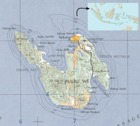 Map of Weh Island | |
| Highest point | |
| Elevation |
617 m (2,024 ft) [1] |
| Listing | Spesial Ribu |
| Coordinates | 5°49′N 95°17′E / 5.82°N 95.28°E |
| Geography | |
| Location | northwest of Sumatra, Indonesia |
| Geology | |
| Mountain type | Stratovolcano |
| Last eruption | Pleistocene time |
Weh Island or Pulau Weh or Pulo Weh (by the local population commonly referred to only as "Sabang", the name of the largest city) is a small active volcanic island to the northwest of Sumatra, 45 minutes by fast regular ship or 2 hours by ferry from mainland, Banda Aceh.[2] It was originally connected to the Sumatran mainland and became separated by sea after the volcano's last eruption in the Pleistocene era.[1] The island is situated in the Andaman Sea. The largest city on the island, Sabang, is the northernmost outpost of Indonesia.
The island is known for its ecosystem; the Indonesian government has declared 60 square kilometres (23 sq mi) of inland and sea around the island as a wildlife protection area. A rare megamouth shark species was found on shore and the island is the only habitat for the threatened toad, Duttaphrynus valhallae (formerly Bufo valhallae). Coral reef areas around the island are known for their large variety of fish species.
Geography
Weh Island is located in the Andaman Sea, where two groups of islands, the Nicobar Islands and Andaman Islands, are scattered in one line from Sumatra to the north up to the Burma plate. The Andaman Sea lies on an active moving small tectonic plate (microplate). A complex geological fault system and volcanic arc islands have been created along the length of the sea by the movement of the microplate.[3]
The island lies about 15 kilometres (9 mi) off the northernmost tip of Sumatra. The island is small at only 156.3 km2 (60.3 sq mi), but mountainous. The highest peak is a fumarolic volcano, 617 metres (2,024 ft) high.[1] The last known eruption is estimated to have occurred in the Pleistocene age, as a result which the mountain partially collapsed and was filled by the sea, forming a separate island.
At a depth of 9 metres (30 ft), close to Sabang city, underwater fumaroles emerge from the seabed.[4] At Gapang Beach (Gapang is name of a kind of a tree), one hour from Balohan Port to the west there is also underwater fumaroles which is suitable for diving and is called as Hydrothermal Point.[2] A volcanic cone is found in the jungle. There are three solfatara (mudpot) fields on the island: one is 750 metres (0.5 mi) southeast of the summit and the others are 5 kilometres (3 mi) and 11.5 kilometres (7 mi) northwest of the summit, on the western shore of Lhok Perialakot bay.
There are four islets surrounding Weh Island: Klah, Rubiah, Seulako, and Rondo. Among those, Rubiah is well known for diving tourism, because of its coral reefs. When traveling to Saudi Arabia was only possible by sea, Rubiah was used as a place of quarantine for Indonesian Muslims during the Hajj pilgrimage season.[5]
Inhabitants
Weh Island is a part of Aceh province. A 1993 census reported 24,700 inhabitants.[6] The large majority of the population are Acehnese and the remaining are Minangkabau, Javanese, Batak and Chinese.[7] It is unknown when the island was first inhabited. Islam is the main religion, as Aceh is a special province where Sharia law has been applied exclusively for the province. However, there are some Christians and Buddhists on the island. They are mostly Javanese, Batak and Chinese.
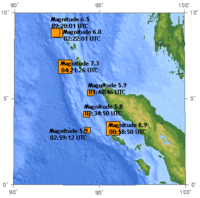
On 26 December 2004, a massive (9.0 on Richter scale) undersea earthquake struck in the Andaman Sea. The earthquake triggered a series of tsunamis that killed at least 130,000 people in Indonesia alone.[8] The effect on the island was relatively small,[9] but it is unknown how many of its inhabitants were killed by the event.
Economy

The economy on Weh Island is dominated by agriculture. The main products are cloves and coconuts.[7] Small-scale fisheries operate in the area, and fishermen have used explosives and cyanide fishing extensively. Therefore, since 1982, a wildlife protection area (suaka alam) has been declared by the Indonesian government that includes 34 square kilometres (13 sq mi) inland and 26 square kilometres (10 sq mi) of surrounding sea.[6]
The two main cities are Sabang and Balohan. Balohan is a ferry port that serves as a hub between the island and Banda Aceh on the mainland Sumatra. Sabang has been an important quay since the late nineteenth century, because the city overlooks the entry to a busy shipping route, Malacca Strait.
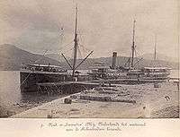
Before the Suez Canal was opened in 1869, the Indonesian archipelago was reached via the Sunda Strait from Africa. From the Suez Canal, the route to Indonesia is shorter via the Malacca Strait. Due to its natural harbour with relatively deep and well sheltered water, the Dutch East Indies government decided to open Sabang as a quay. In 1883, Sabang quay was opened for ships to dock by the Atjeh Associate.[10] At first, the harbour was intended as a coal station for the Dutch navy, but later also served merchant vessels and for the transfer of export goods from northern Sumatra.
Each year, 50,000 vessels pass through Malacca Strait.[11] In 2000, the Indonesian government declared Sabang a Free Trade Zone and Free Port, to gain economic benefit by establishing the port as a logistic hub for international vessels passing through the strait.[12] Infrastructures for a deep water harbour, port, warehousing and refuelling facilities, were developed.
Weh Island is served by the Maimun Saleh Airport located in Sabang. Currently there is no airlines serving that airport. Thus, the nearest airport to get into Sabang is the Sultan Iskandarmuda Airport which is located at Banda Aceh. From the airport of Banda Aceh, it's about a half-hour drive to Ulee Lheu, close to the center of Banda Aceh, from where the ferries to Balohan (Pulau Weh's ferry harbour) are leaving.
Weh Island is also known for ecotourism. Underwater diving, hiking through the volcanic mountain and beach resorts are the main attractions. A small village, Iboih, is known as a location for scuba diving. A few meters from Iboih is the Rubiah islet that is known for its coral reefs.[13] There are also several dive operators in Gapang.
Ecosystem
During 1997–1999, Conservation International conducted a survey of the coral reef in the area.[6] According to the survey, the coral diversity is relatively low, but fish species variation is rich. Some species found during the survey include Pogonoperca ocellata, Chaetodon gardneri, Chaetodon xanthocephalus, Centropyge flavipectoralis, Genicanthus caudovittatus, Halichoeres cosmetus, Stethojulis albovittatus, Scarus enneacanthus, Scarus scaber and Zebrasoma desjardinii.[6]
On 13 March 2004, a specimen of the rare and unusual species of shark, megamouth shark, was washed ashore on Gapang beach.[14] Megamouth shark has a distinctive large mouth, very short snout and is broadly rounded in dorsal view. The specimen is said to be the 21st[14] (some say it is the 23rd[15]) sighting of the species since its discovery in 1976. The male shark, measuring 1.7 metres (5.6 ft) in length and weighing 13.82 kg (30.5 pounds), was frozen and sent to the Indonesian Institute of Sciences (LIPI) for further scientific study. As of 2006, there have only been 36 findings of megamouth sharks in the Pacific, Indian and Atlantic oceans.[16]
The 2004 earthquake and tsunami has affected the island's ecosystem.[17] At Iboih village, a large swath of mangrove was destroyed. Debris from the land was deposited on the nearby reefs as a result of the tsunami. In 2005, about 14,400 mangrove seedlings were replanted to save the mangrove forest.[18]
Apart from underwater ecosystem, Weh island is the only habitat of one threatened species of toad, Duttaphrynus valhallae (formerly Bufo valhallae). The species is only known from the holotype from the island. Due to heavy forestation on the island, the survival of the species is uncertain.[19]
Sabang International Regatta
Sabang International Regatta was held on September 13 to 25, 2011. The participants were expected from Australia, United States, England, Germany, Malaysia, Singapore, Thailand and Hong Kong.[20]
Tourism
Weh Island is small island and some beaches can be visited in one day only by rental vehicles, because there are no public transport there.
- Anoi Itam Beach with its black sandy beach is a half-hour drive from Balohan Port. With small fee, visitor can enter Anoi Itam Resort with beautiful scenery.
- Gapang Beach is 17 miles (27 km) from Sabang or one hour drive and covinience for backpackers with modest culinary stalls and accommodations, however has a dive resort.[21]
- Iboih Beach, 5 km (3 mi) from Gapang Beach is the busiest beach in Weh Island and is cheaper than Gapang Beach. The white sandy beach itself is only 150 metres (492 ft) long, yet it is considered a paradise for backpackers because Rubiah Island is directly offshore from it.[22][23]
See also
References
- 1 2 3 "Pulau Weh". Global Volcanism Program. Smithsonian Institution. Retrieved 2006-11-16.
- 1 2 "April 11, 2012 - Pesona surga nan indah di ujung barat Indonesia".
- ↑ Curray, J.R. (2005). "Tectonics and history of the Andaman Sea region". Journal of Asian Earth Sciences. 25 (1): 187–232. Bibcode:2005JAESc..25..187C. doi:10.1016/j.jseaes.2004.09.001.
- ↑ "Pulau Weh Volcano, Indonesia". John Seach. Retrieved 2006-11-23.
- ↑ "Weh Island, a piece of land from heaven". Aceh Tourism Office. Retrieved 2006-11-30.
- 1 2 3 4 G.R., Gerald R.; Werner,T.B. (2002). "Coral Reef Fish Assessment in the 'Coral Triangle' of Southeastern Asia". Environmental Biology of Fishes. 65 (2): 209–214. doi:10.1023/A:1020093012502.
- 1 2 "The people of Weh Island". Aceh Tourism Office. Retrieved 2006-11-30.
- ↑ "The Human Toll" (Press release). UN Office of the Special Envoy for Tsunami Recovery. Retrieved 2006-11-23.
- ↑ "Waves of Mercy Says Goodbye to Pulau Weh". Indonesia Relief. 11 June 2005. Archived from the original on October 4, 2006. Retrieved 2006-11-23.
- ↑ "Sabang". ABN AMRO History. ABN AMRO. Archived from the original on October 22, 2006. Retrieved 2006-11-30.
- ↑ "IMO to take Straits initiative". International Maritime Organization. Retrieved 2006-11-24.
- ↑ "Free Trade Zone and Free Port of Sabang" (Press release). Government of Indonesia. 1 September 2000. Retrieved 2006-11-30.
- ↑ "Pulau Weh". Asia Dive Site. Retrieved 2006-11-21.
- 1 2 White, W.T.; Fahmi,M.A.; Sumadhiharga,K. (2004). "A Juvenile Megamouth Shark Megachasma Pelagios (Lamniformes: Megachasmidae) From Northern Sumatra, Indonesia" (PDF). The Raffles Bulletin of Zoology. 52 (2): 603–607.
- ↑ "Megamouth Shark #23 Washes Up in Sumatra, Indonesia". Florida Museum of Natural History. 13 March 2004. Retrieved 2006-11-21.
- ↑ "Distribution Table of Confirmed Megamouth Shark Sightings". Florida Museum of Natural History. Retrieved 2006-11-21.
- ↑ "USGS Scientists in Sumatra Studying Recent Tsunamis: Leg 2 Reports, 12 April to 30 April 2005". USGS. Retrieved 2006-11-23.
- ↑ "Seacology News". Seacology. 9 July 2005. Retrieved 2006-11-23.
- ↑ Iskandar, D. & Mumpuni (2004). "Duttaphrynus valhallae". IUCN Red List of Threatened Species. Version 2015.2. International Union for Conservation of Nature. Retrieved 13 September 2015.
- ↑ "Ministry to organize Sabang international regatta to attract tourist". 13 May 2011.
- ↑ "Gapang Beach, The Beauty in The Edge of Indonesia's Archipelago". Retrieved February 17, 2015.
- ↑ Suan Natalia Poskitt. "Pantai di Pulau Weh". Retrieved February 18, 2015.
- ↑ "Pantai Iboih, Surga Tersembunyi". Retrieved February 18, 2015.
External links