Qaleh Ganj
For the administrative subdivisions, see Qaleh Ganj County and Qaleh Ganj Rural District.
| Qaleh Ganj قلعه گنج | |
|---|---|
| city | |
|
Azadegan Blvd. Vali Asr Square | |
 Qaleh Ganj | |
| Coordinates: 27°31′25″N 57°52′52″E / 27.52361°N 57.88111°ECoordinates: 27°31′25″N 57°52′52″E / 27.52361°N 57.88111°E | |
| Country |
|
| Province | Kerman |
| County | Qaleh Ganj |
| Bakhsh | Central |
| Government | |
| • Shahrdar | Seyyed Reza Hosseyni |
| Area | |
| • Total | 14,200 km2 (5,500 sq mi) |
| Population (2010) | |
| • Total | 12,663 |
| • Density | 0.89/km2 (2.3/sq mi) |
| Time zone | IRST (UTC+3:30) |
| • Summer (DST) | IRDT (UTC+4:30) |
| Area code(s) | +34 |
| Website | Qaleh Ganj municipality |

Qaleh Ganj (Persian: قلعه گنج, also Romanized as Qal‘eh Ganj and Qal‘eh-ye Ganj; also known as Ghal‘eh Ganj, Kalāteh-ye Ganj, Kalāt-i-Ganj, and Moḩammadābād)[1] is a city in and the capital of Qaleh Ganj County, Kerman Province, Iran. At the 2010 census, its population was 12,663, in 3,034 families.[2]
History
Investigation on the history of this city is very difficult and dramatic. It Belongs to the pre-Islamic and Nativity which shows relatives who have been living everywhere this city. Remains from this civilization show the city is over 5,000 years old. Now That people who live in this city are Persians, Balouch, Arabs and Bakhtiari.
References
- ↑ Qaleh Ganj can be found at GEOnet Names Server, at this link, by opening the Advanced Search box, entering "-3079165" in the "Unique Feature Id" form, and clicking on "Search Database".
- ↑ "Census of the Islamic Republic of Iran, 1385 (2006)". Islamic Republic of Iran. Archived from the original (Excel) on 2011-11-11.
| Capital | 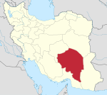 | ||||||||||||||||||||||||||||||||||||||||||||||
|---|---|---|---|---|---|---|---|---|---|---|---|---|---|---|---|---|---|---|---|---|---|---|---|---|---|---|---|---|---|---|---|---|---|---|---|---|---|---|---|---|---|---|---|---|---|---|---|
| Counties (A-L) and cities | |||||||||||||||||||||||||||||||||||||||||||||||
| Counties (M-Z) and cities | |||||||||||||||||||||||||||||||||||||||||||||||
| Sights |
| ||||||||||||||||||||||||||||||||||||||||||||||
| Places | |||||||||||||||||||||||||||||||||||||||||||||||
This article is issued from Wikipedia - version of the 7/21/2016. The text is available under the Creative Commons Attribution/Share Alike but additional terms may apply for the media files.