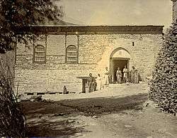
Konak, Hakkari


_(14760204091).jpg)
Konak is the modern Turkish name for a village in the province of Hakkari, traditionally called Qodchanis (pronounced Ko-cha-niss; Syriac: ܩܘܕܫܐܢܣ Qudshānes, also spelt Qudshanes, Kotchanes, Qochanis or Kocanis). It was the seat of the Patriarchs of the Assyrian Church of the East until 1918.
The village is situated about 20 km northeast of the provincial capital Hakkâri of Hakkâri Province in the southeastern corner of Turkey, near the borders of Iran and Iraq.
History
The village was founded in 1672 by Chaldean Catholics from the city of Amida, who upon settling here broke off with the Catholic church and founded a new branch of the Assyrian Church of the East in 1692, ruled by the Shimun line. From that point on the village functioned as the de facto capital of The Assyrian tribes in the region. The Government of the Hakkari mountains was that of a tribal confederation, with Assyrian tribes such as the Tyari and Nochiya living in villages across the region, with their own leaders known as Maliks (ܡܠܟ). The Tribes were subservient to the Patriarch, based in Qochanis, and paid him taxes, with which the patriarch then gave to the Ottomans.[1] Therefore, the patriarch functioned as a king of sorts for the Assyrians of the mountains, and therefore his See in Quochanis functioned as the capital of their confederation. The Confederation was in effect almost like a vassal state ruled by the Ottoman Empire, and even then the Assyrians were not subservient to the Sultan, but rather the Patriarch. Hence why upon his declaration of war in 1915 the tribes of the region immediately went into open rebellion against the Turks.[2] 3 years into this war in 1918, they were forced off of their ancestral lands in the Assyrian Genocide, never to return again. After the forced expulsion of the Assyrian inhabitants of the village, from the 1920s until the war between the Turkish government and the PKK in the 1990s, the village was inhabited by Kurds. Now, the village is uninhabited, and largely in ruins. One of the only buildings still standing is the Patriarchal church of Mar Shalita.[3]
The village is in a relatively isolated area, and was for many years cut off from the outside world up until the 1829, when a German traveler found it. After that, more visitors from the west began arriving as emissaries.[4] One of these emissaries, An Englishman known as William Ainger Wigram, wrote this when describing it in his book The cradle of mankind (1922):
"The village of Qudshanis, which is the residence of the Nestorian or Assyrian Patriarch, Mar Shimun,“ and the headquarters of his Church, has a marvellous situation. It lies on a sloping alp of rugged pasture, between two mountain torrents which spring from the towering snow-fields to the west of it; and which descend in gradually deepening gorges, enclosing the tongue-shaped plateau on which the village stands. They meet beneath the point of the tongue at the base of a lofty wedge of rock; and thence the united stream flows on, joined by others on its way, till it falls into the Zab some two hours below the village. Nestorian tradition regards the Zab as the Pison [or Pishon/Uizhun], one of the four rivers of Paradise; and the Patriarch will occasionally date his official letters from my cell on the River of the Garden of Eden.”[5]
See also
- List of Patriarchs of the Church of the East
- List of Assyrian villages
- Assyrian tribes
- Assyrian Church of the East
Notes
- ↑ "The wild Christian tribes of Hakkiari, whither no Government of any sort has ever extended, still pay tribute to their Patriarch for transmission to the Sultan; and not taxes through the tax-collector"
- ↑ Stafford, R (2006) [1935], The Tragedy of the Assyrians, Gorgias Press, ISBN 978-1-59333-413-0.
- ↑ http://www.aina.org/books/com/com.htm
- ↑ http://www.jelleverheij.net/monuments/patriarchal-church-of-the-church-of-the-east.html
- ↑ Wigram, p. 90
References
- Wigram, W. A. (2004). An introduction to the history of the Assyrian Church, or, The Church of the Sassanid Persian Empire, 100–640 A.D. Gorgias Press. ISBN 1-59333-103-7.
External links
Coordinates: 37°38′34.44″N 43°47′21.84″E / 37.6429000°N 43.7894000°E