Quézac, Lozère
| Quézac | ||
|---|---|---|
|
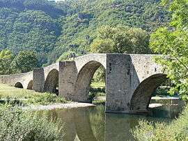
Bridge over the Tarn River in Quézac | ||
| ||
 Quézac | ||
|
Location within Occitanie region  Quézac | ||
| Coordinates: 44°22′15″N 3°31′33″E / 44.3708°N 3.5258°ECoordinates: 44°22′15″N 3°31′33″E / 44.3708°N 3.5258°E | ||
| Country | France | |
| Region | Occitanie | |
| Department | Lozère | |
| Arrondissement | Florac | |
| Canton | Sainte-Enimie | |
| Intercommunality | Gorges du Tarn et des Grands Causses | |
| Government | ||
| • Mayor (2008–2014) | Josseline Longepée[1] | |
| Area1 | 26.91 km2 (10.39 sq mi) | |
| Population (1999)2 | 245 | |
| • Density | 9.1/km2 (24/sq mi) | |
| Time zone | CET (UTC+1) | |
| • Summer (DST) | CEST (UTC+2) | |
| INSEE/Postal code | 48122 / 48320 | |
| Elevation |
479–1,080 m (1,572–3,543 ft) (avg. 600 m or 2,000 ft) | |
|
1 French Land Register data, which excludes lakes, ponds, glaciers > 1 km² (0.386 sq mi or 247 acres) and river estuaries. 2 Population without double counting: residents of multiple communes (e.g., students and military personnel) only counted once. | ||
.svg.png)
Quézac is a commune in the Lozère department in southern France.
See also
References
| Wikimedia Commons has media related to Quézac. |
This article is issued from Wikipedia - version of the 2/11/2016. The text is available under the Creative Commons Attribution/Share Alike but additional terms may apply for the media files.