Palmerston, Northern Territory
| Palmerston Northern Territory | |
|---|---|
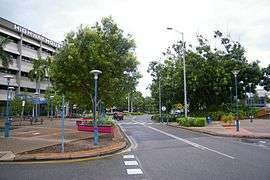 Palmerston central business district | |
|
Palmerston | |
| Coordinates | 12°28′50″S 130°58′59″E / 12.48056°S 130.98306°ECoordinates: 12°28′50″S 130°58′59″E / 12.48056°S 130.98306°E |
| Population | 27,618 (2011 census)[1] |
| • Density | 9.1/km2 (24/sq mi) |
| Established | 1981 |
| Postcode(s) | 0830 |
| Area | 52.9 km2 (20.4 sq mi) |
| Time zone | ACST (UTC+9:30) |
| Location |
|
| LGA(s) | City of Palmerston |
| County | County of Palmerston |
| Territory electorate(s) | |
| Federal Division(s) | Solomon |
Palmerston is a planned satellite city of Darwin, the capital and largest city in Australia's Northern Territory. Palmerston is situated near Darwin Harbour and had a population of 27,618 at the 2011 census, making it the second largest city in the sparsely populated Northern Territory.[1] Palmerston is currently the fastest growing city in the Northern Territory and has briefly in the past held the title of the fastest growing city in Australia.
There are eighteen suburbs in Palmerston, ten of which are close to the Palmerston city centre. Palmerston is mostly residential with two light industrial areas in the north of the city.
Like the rest of the Top End, Palmerston has a tropical climate, with a wet season and a dry season. It receives heavy rainfall during the Wet, and is well known for its spectacular lightning.
History
1864–1911

Palmerston was the name chosen in 1864[2] for the capital of the Northern Territory by the South Australian Government (which was then responsible for its administration) in recognition of Lord Palmerston, who became Prime Minister of the United Kingdom of Great Britain and Ireland in 1855.[3] The first site, as chosen by Boyle Travers Finniss at Escape Cliffs[4] near the mouth of the Adelaide River, on the coast of Adam Bay on the western side of the Cape Hotham peninsula in 1864,[5] was abandoned in 1867 and a second laid out by Surveyor-General George Goyder near Port Darwin in 1869.[6] The town was officially renamed Darwin in April 1911[7] after responsibility for the Northern Territory passed to the Commonwealth of Australia and was officially gazetted as the City of Darwin in 1959.[8]
1971–present
The land for a new satellite city of Darwin was acquired in 1971 by the Australian government after concerns of under-supply of residential land in Darwin. The site was selected as the land was adjacent to existing transportation corridors. The decision to proceed with the development was made in 1980 and for the third time, the name of Palmerston was selected for the new city. Planning and development was managed by the Palmerston Development Authority.[9]
Development of Palmerston began during the early 1980s. Suburbs of Palmerston were built in stages. The first suburbs built were Gray and Driver, followed by Moulden, then Woodroffe and Marlow Lagoon. The urban area continued to grow throughout the 1990s, with the new suburbs of Bakewell, Rosebery and Durack. The population growth of Palmerston continues to be the highest in the Northern Territory.
The population increased by almost 8,000 people between 1991 and 2001 to a total of 21,000 people. Palmerston's population growth is expected to continue and reach over 40,000 people in the next 10 – 15 years.[10] It was initially anticipated that Palmerston would house 50,000 residents, however current trends show that that actual figure will more likely be lower than 42,000.
Since 1995/1996 the construction commenced on 5 new Palmerston suburbs, Rosebery, Bakewell, Durack, Gunn, and Farrar. These were developed in stages with only the final stages of new Palmerston suburbs yet to begin. In 2000 the Palmerston Town Council sought and obtained a change in the name of the municipality to City of Palmerston.[11]
Palmerston is approximately a 15-minute drive away from the Darwin city centre, 15–18 minutes from Darwin's Northern suburbs and 10 – 20 minutes from Howard Springs and the rural area.
Landmarks
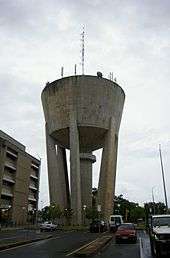
The major land-mark in Palmerston is the Power and Water Corporation's water storage tank, which supplies the city with fresh potable water. The City formally had a large escarpment with extensive walking paths and a small creek, but has now being demolished and converted into a grassed open space, primarily used for the Palmerston Markets.
Geography
Palmerston is located between the outer industrial areas of Darwin and the rural areas of Howard Springs, 21 kilometres (13 mi) south – east of territories capital Darwin, and is situated in the local government area of the City of Palmerston.
The urban area of Palmerston extends from the Stuart Highway in the north and in the eastern parts to the Cty of Palmerston borders. The city itself is located in the centre, with the outer rural area proposed for development as the population grows.[12]
Palmerston like Darwin has a tropical climate, with a wet season and a dry season. The city receives heavy rainfall in the wet season, this occurs between December and March. Thunderstorms are common and humidity is regularly over 70 per cent.
Regions and suburbs

The City of Palmerston initially consisted of the Palmerston Town (CBD), Driver and Gray. These were followed by Moulden and Woodroffe after development in those areas commenced in 1983. Also included in the City of Palmerston are the semi-rural suburb of Marlow Lagoon, the suburb of Archer and the industrial zones of Yarrawonga and Pinelands. Due to the explosive growth of Palmerston, further developments have occurred leading to the creation of the suburbs of Rosebery, Bakewell, Gunn, Durack and more recently Farrar.
The suburbs of Durack and Gunn also have unofficial names as assigned to them by the developers of the area, being "Fairway Waters" (due to the man-made lakes and golf course) and "The Chase" respectively.
Future areas of land for expansion are the proposed suburbs of Archer, Bellamack, Johnston, Zuccoli and Mitchell and are located on the south-east side of the existing city. These plots of expansion are expected to allow an increase of up to 14,000 additional residents in the city of Palmerston, with the first land release beginning in Bellamack in 2009.[13][14]
Climate
Palmerston has a tropical climate like Darwin with distinct wet and dry seasons. The dry season runs from May to September. In the coolest months of June and July, daily temperature range is 19 to 30 °C. The Wet season is associated with tropical cyclones and monsoon rains. The majority of rainfall occurs between December and March when thunderstorms are common and humidity is regularly over 70 per cent.
| Month | Jan | Feb | Mar | Apr | May | Jun | Jul | Aug | Sep | Oct | Nov | Dec | Year |
|---|---|---|---|---|---|---|---|---|---|---|---|---|---|
| Temperatures (°C) | |||||||||||||
| Mean daily maximum | 31.8 | 31.4 | 31.9 | 32.7 | 32.0 | 30.6 | 30.5 | 31.3 | 32.5 | 33.2 | 33.2 | 32.6 | 32.0 |
| Highest recorded maximum | 35.6 (4th 1985) |
36.0 (20th 1972) |
36.0 (13th 1942) |
36.7 (16th 2003) |
36.0 (2nd 1942) |
34.5 (5th 2003) |
34.8 (8th 1998) |
36.0 (26th 1998) |
37.7 (17th 1983) |
38.9 (18th 1982) |
37.3 (28th 2004) |
37.0 (18th 1976) |
|
| Lowest recorded maximum | 25.7 (29th 1989) |
25.6 (3rd 1956) |
25.7 (22nd 1960) |
24.6 (10th 1954) |
22.7 (20th 1981) |
22.7 (20th 2007) |
21.1 (14th 1968) |
25.1 (17th 2007) |
27.6 (29th 1986) |
24.7 (20th 2000) |
26.2 (19th 1981) |
24.0 (17th 1954) |
|
| Mean daily minimum | 24.8 | 24.7 | 24.5 | 24.0 | 22.1 | 19.9 | 19.3 | 20.4 | 23.0 | 25.0 | 25.3 | 25.3 | 23.2 |
| Highest recorded minimum | 29.3 (28th 2002) |
29.4 (3rd 1988) |
28.3 (3rd 1958) |
26.6 (12th 1992) |
25.6 (12th 2001) |
25.1 (9th 1979) |
25.6 (13th 1981) |
26.7 (27th 1998) |
28.8 (23rd 2005) |
29.7 (25th 1987) |
29.7 (3rd 2007) |
29.8 (21st 1984) |
|
| Lowest recorded minimum | 20.2 (23rd 1985) |
17.2 (25th 1949) |
19.2 (31st 1945) |
16.0 (11th 1943) |
13.8 (27th 1990) |
12.1 (23rd 1963) |
10.4 (29th 1942) |
13.2 (2nd 1990) |
14.3 (1st 2006) |
19.0 (20th 2000) |
19.3 (4th 1950) |
19.8 (4th 1974) |
|
| Precipitation (millimetres) | |||||||||||||
| Mean total rainfall | 420.4 | 362.7 | 323.8 | 100.3 | 20.7 | 2.0 | 1.3 | 5.4 | 15.3 | 68.5 | 140.4 | 246.2 | 1714.7 |
| Highest recorded total | 940.4 (1995) |
814.5 (1969) |
1013.6 (1977) |
396.2 (2006) |
298.9 (1968) |
50.6 (2004) |
26.6 (2001) |
83.8 (1947) |
129.8 (1981) |
338.7 (1954) |
370.8 (1964) |
664.5 (1974) |
2776.6 (1998) |
| Lowest recorded total | 136.1 (1965) |
103.3 (1959) |
88.0 (1978) |
0.6 (1997) |
0.0 (2003) |
0.0 (2006) |
0.0 (2007) |
0.0 (2006) |
0.0 (2001) |
0.0 (1953) |
17.2 (1976) |
18.8 (1991) |
1024.7 (1946) |
| Highest daily rainfall | 290.4 (3rd 1997) |
250.2 (18th 1955) |
240.6 (16th 1977) |
142.7 (4th 1959) |
89.6 (18th 1987) |
46.8 (2nd 2004) |
19.2 (17th 2001) |
80.0 (22nd 1947) |
70.6 (21st 1942) |
95.5 (25th 1969) |
96.8 (26th 1992) |
277.0 (25th 1974) |
|
| Notes: Temperatures are in degrees Celsius. Precipitation is in millimetres. Darwin Airport Latitude: −12.42° S Longitude: 130.89° E Elevation: 30 m ASL | |||||||||||||
Demographics
| Historical population | ||
|---|---|---|
| Year | Pop. | ±% |
| 1986 | 5,706 | — |
| 1991 | 7,804 | +36.8% |
| 1996 | 12,750 | +63.4% |
| 2001 | 20,788 | +63.0% |
| 2006 | 23,614 | +13.6% |
| 2011 | 27,618 | +17.0% |
| 2014 | 33,900 | +22.7% |
| Source: City of Palmerston[15] | ||
As of the 2006 Census, there were 23,614 people residing in 9,000 households. The median age of persons in Palmerston was 28 years. 18.9% of the population of Palmerston were children aged between 5–14 years, and 47.1% were persons aged 25–54 years.[16] 74.8 per cent of Palmerston's population are Australian born, with the biggest overseas birthplaces were, English (692 or 2.9 per cent), New Zealand (437 or 1.9 per cent), Philippines (278 or 1.2 per cent), Papua New Guinea (144 or 0.6 per cent) and East Timor (116 or 0.5 per cent).[16]
The 2006 Census found the most common religious affiliations in Palmerston had No Religion (6,106 or 25.9 per cent), Catholicism (5,263 or 22.3 per cent), Anglican (3,561 or 15.1 per cent), Uniting Church (1,205 or 5.1 per cent) and Presbyterian and Reformed (419 or 1.8 per cent).[16]
Palmerston’s population represents one quarter of the combined Palmerston-Darwin total population, and represents 11.7% of the Territory’s population.[17]
Population growth
Palmerston along with Darwin is one of the fastest growing cities in the Northern Territory and in Australia. Palmerston recorded the fastest increase of population of all the Local Government Areas in the Northern Territory. Palmerston increased by 1,300 people growing by 5 per cent. The fastest growths occurred within Palmerston which includes the suburbs of Farrar Rosebery, Marlow Lagoon and Gunn and Palmerston City.[18] By 2016 the population of Palmerston will be over half the size of Darwin's population, and the combined Palmerston-Litchfield population will be over 4 000 more than the City of Darwin.
Government

The Palmerston region is covered by the Local Government Area of the City of Palmerston. The council was created in 1985. The council chambers are located in the Palmerston City Centre.
The Palmerston City Council (Incorporated under the Northern Territory Local Government Act 1993) governs the City of Palmerston which takes in the CBD and the suburbs. The City of Palmerston has governed Palmerston since 1985. It is governed by a seven-member council comprising the mayor, deputy mayor and five aldermen. The city is not divided into wards; all councillors are elected at large.[19] The current mayor of Palmerston is Ian Abbott. Mayor Ian Abbott was elected in the Local Government Election on 24 March 2012.
In territory politics, Palmerston is split between five Legislative Assembly districts. The districts of Blain, Brennan and Drysdale are entirely within the city. The district of Spillett is located mostly within Palmerston, but spills into eastern Darwin. The mostly rural district of Nelson spills into the city. Historically, Palmerston has been a bastion of conservatism, with Country Liberal Party candidates usually winning by wide margins. Labor never came remotely close to winning seats in Palmerston until 2005, when that year's massive Labor landslide saw Labor take Brennan and Drysdale off the CLP. However, those seats reverted to form in the 2008 election.
At the 2016 general election, however, Labor took Brennan and Drysdale off the CLP, while Blain fell to independent Terry Mills, a former CLP Chief Minister. Currently, Palmerston is represented by two Labor members, two independents, and one CLP member.
In federal politics, Palmerston is located in one House of Representatives division shared with Darwin – the Division of Solomon. The MP from 2010 to 2016, Natasha Griggs, is a Palmerston resident and a former member of Palmerston City Council.
Economy
Palmerston has around 12,945 people in the labour force. The unemployment rate in the city was 2.3 per cent which was well below the Northern Territory average of 4.3 per cent.
The largest industry employers in Palmerston are public administration & safety (2,751 or 21.3 per cent), retail trade (1,190 or 9.2 per cent), construction (892 or 6.9 per cent), health care & social assistance (829 or 6.4 per cent) and education & training (825 or 6.4 per cent).[20] The total numbers of businesses in Palmerston was 1,410. Of these, 57% of businesses were categorised as non employing.
Palmerston has continued growth in median house prices, with an increase of 5.3% for the year to March 2008. The median unit and house prices in Palmerston were $695,000 and $950,000. The vacancy rate in Palmerston was 0.9% compared with 0.5% for Darwin. Palmerston has provided around a half of the vacant land sales in the Northern Territory.[21]
Palmerston has two major shopping centres including Palmerston Shopping Centre and Palm City Oasis. The Palmerston Shopping Centre contains over 69 businesses including a Coles Supermarket, and the discount department – store Target. Palm City Oasis contains a Woolworths supermarket and 18 businesses. Currently under construction is the Northern Territories largest shopping centre, The Gateway Shopping Centre, which is planned to be 2.5 larger than the Casurina Shopping Square. Palmerston suburbs contains smaller shopping centres
Education

Preschool, primary and secondary
Palmerston is served by eight primary schools and two secondary schools and three non – government schools.[22] There are over 5,867 primary and secondary students enrolled in Palmerston with 2,942 students attending primary education and 1,292 students attending secondary education.[23] There are over 3,100 students enrolled in government schools in Palmerston, 509 students enrolled in Catholic schools and 625 students enrolled in independent schools.
The Northern Territory Government announced in its 2008 Budget that two new schools a primary and middle schools will be built in the Palmerston suburb of Rosebery which will cater for up to 1,450 students and will cost $48.8million. Following the construction of the two new schools in Rosebery an additional primary schools will be built in Palmerston East, which will include the planned suburb of Zuccoli.[24]
Tertiary and vocational
The Charles Darwin University Palmerston campus is located in the suburb of Durack. The campus hosts the School of Tourism and Hospitality as well as expanding into a mini-School of Conservation and Land Management. There are over 4,318 students enrolled in tertiary and further education courses.[25] 247 of Palmerston residents were enrolled in higher education at Charles Darwin University and 4,071 students enrolled in vocational education and training.[26]
Sport and recreation
Palmerston is home to the Palmerston Football Club (known as the "Magpies") Northern Territory Football League and is based out of the Archer Sporting Complex.[27] Palmerston has a strong presence in Australian rules football. The Archer Sporting Complex has an Australian rules football field, a senior Softball diamond and senior Baseball diamond. There are also a number of sporting clubs located at the complex. The complex home to the, Palmerston and Rural Baseball Club, the Palmerston Pirates Softball team, and the Palmerston Raiders Rugby League team.
Palmerston has one association football team, the Palmerston SC which plays in the Northern Zone League.
The city has a skate park located on University Avenue that is funded by the Palmerston City Council. There is also a local near-Olympic size swimming pool with a gymnasium.
There is also a boat ramp allowing access to the Elizabeth River for small trail-able marine craft. Persons utilising the area are cautioned that both Box jellyfish and crocodiles are present in the river.
A branch of the YWCA is located at the CBD.
The Palmerston Scouts are located on University Avenue, adjacent to the Palmerston branch of the RSL.
Palmerston has one major tennis centre. Opened in January 2012 it includes 7 courts, BBQ area and canteen. The centre offers group coaching and competition opportunities for people of all ages.
Palmerston is well served by its many park reserves. Some parks also offer coin-operated public barbecue facilities.
Media
A local free tabloid news paper called the Palmerston Sun is published weekly by News Corporation. The Northern Territory News tabloid published daily by News Corporation is also widely available in Palmerston. There is also the Sunday edition of the Northern Territory News The Sunday Territorian also published by News Corporation. Most large statewide and interstate newspapers are also available from local retailers, albeit with a delay in arrival.
Palmerston also receives Radio and television services sourced from transmitters located in the Darwin region. Which include the three commercial channels Southern Cross Darwin, Channel Nine Darwin and Darwin Digital Television and the two Government owned channels ABC and SBS Television. Pay TV is also available through both satellite and fixed cable from the encumbant provider, Austar.
Palmerston receives most Radio stations from Darwin. Which include ABC Local Radio (105.7FM), Radio National (657AM), ABC Classic FM (107.3FM) and Triple J (103.3FM).
Infrastructure
Transport

The city has a network of approximately 32 km (20 mi) of bicycle paths, most of which are lit for night-time usage.
There is also a public bus service operated by Darwinbus that offers transportation around Palmerston, into Darwin City and out to Darwin's Northern Suburbs.
The Darwin City Airport is the closest air terminal, being serviced by Qantas, Jetstar Airways, Airnorth, Garuda Indonesia and Virgin Australia; with daily flights to and from all major cities in Queensland, New South Wales, Western Australia, South Australia, Victoria, and the Northern Territory. There are currently no direct flights to Tasmania or the Australian Capital Territory. There are also direct flights to East Timor, Indonesia, Singapore and Vietnam. The airport is located in the Darwin suburb of Marrara, approximately 20 minutes away from Palmerston.
Darwin-based taxis are also available in Palmerston, as well as a number of local and Darwin-based mini-bus operators.
Utilities
Water storage, supply and Power for Palmerston is managed by Power and Water Corporation, which is owned by the Government of the Northern Territory. The corporation is also responsible for management of sewerage and the major water catchments in the region. Water is mainly stored in the largest dam, The Darwin River Dam which holds up to 90% of Palmerston's water supply. For many years, Palmerston principal water supply came from Manton Dam.
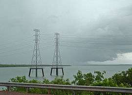
Palmerston and its suburbs are powered by the Channel Island Power Station. The largest power plant in the Northern Territory.
Health
Palmerston does not have a public hospital but many of Palmerston's health needs are serviced by the Palmerston Health Precinct which includes the Palmerston Community Care Centre, public dental service, St Johns' Ambulance, Medical Specialists Clinic and the Farrar Medical Centre. There are seven general practices in the Palmerston health region, four of which provide after-hours services.[28]
References
- 1 2 Australian Bureau of Statistics (31 October 2012). "Palmerston (Statistical Area Level 3)". 2011 Census QuickStats. Retrieved 12 May 2013.
- ↑ "Topics of the Day". The South Australian Advertiser (Adelaide, SA : 1858 – 1889). Adelaide, SA: National Library of Australia. 2 November 1864. p. 2. Retrieved 20 April 2012.
- ↑ "Palmerston City". NT Lands Group. Archived from the original on 23 January 2008. Retrieved 31 March 2008.
- ↑ "Encampment at Escape Cliffs, Palmerston". Illustrated Sydney News (NSW : 1853 – 1872). NSW: National Library of Australia. 15 September 1866. p. 3. Retrieved 20 April 2012.
- ↑ "Escape Cliffs, Palmerston, Northern Territory". Illustrated Sydney News (NSW : 1853 – 1872). NSW: National Library of Australia. 15 September 1866. p. 8. Retrieved 20 April 2012. Drawing of Finniss's camp.
- ↑ "Goyder, George Woodroffe (1826–1898)". Australian Dictionary of Biography. Australian National University. 1972. Retrieved 1 May 2015.
- ↑ "Proclamation". Northern Territory Times and Gazette (Darwin, NT : 1873 – 1927). Darwin, NT: National Library of Australia. 21 April 1911. p. 4. Retrieved 20 April 2012.
- ↑ "History of Darwin". History of Darwin. Darwin City Council. Retrieved http://www.darwin.nt.gov.au/council/educational-resources/history-darwin. Check date values in:
|access-date=(help) - ↑ "Palmerston City History" (PDF). Palmerston City Council. Archived from the original (PDF) on 10 April 2008. Retrieved 10 July 2008.
- ↑ "Palmerston City". NT Community Profile. Archived from the original on 21 May 2008. Retrieved 31 March 2008.
- ↑ "Palmerston City Suburban Growth" (PDF). Palmerston City. Archived from the original (PDF) on 21 July 2008. Retrieved 10 July 2008.
- ↑ "About Palmerston". City of Palmerston. Archived from the original on 7 November 2007. Retrieved 2 April 2008.
- ↑ "Tenders Called for Bellamack Headworks". Northern Territory Government. Retrieved 5 July 2008.
- ↑ "High Level Of Interest In Bellamack". Northern Territory Government. Retrieved 5 July 2008.
- ↑ "Demographics". City of Palmerston. Retrieved 20 November 2011.
- 1 2 3 Australian Bureau of Statistics (25 October 2007). "Palmerston (Urban Centre/Locality)". 2006 Census QuickStats. Retrieved 2 April 2008.
- ↑ "Palmerston City Population" (PDF). Palmerston City. Archived from the original (PDF) on 21 July 2008. Retrieved 31 March 2008.
- ↑ "Palmerston population ABS". Australian Bureau of Statistics. Retrieved 20 April 2008.
- ↑ "City of Palmerston Elected Members". City of Palmerston. Archived from the original on 7 November 2007. Retrieved 20 April 2008.
- ↑ "Palmerston Economy". Northern Territory Government. Archived from the original on 3 April 2008. Retrieved 18 July 2008.
- ↑ "Palmerston Real Estate". Northern Territory Government. Archived from the original on 3 April 2008. Retrieved 18 July 2008.
- ↑ "City of Palmerston Schools" (PDF). City of Palmerston. Archived from the original (PDF) on 27 October 2007. Retrieved 15 May 2008.
- ↑ "Palmerston ABS education census table". ABS. Retrieved 15 May 2008.
- ↑ "Two New Schools for Palmerston". Northern Territory Government. Retrieved 18 July 2008.
- ↑ "Community id Schools". City of Palmerston. Archived from the original on 21 May 2008. Retrieved 15 May 2008.
- ↑ "Palmerston Education". Northern Territory Government. Archived from the original on 3 April 2008. Retrieved 18 July 2008.
- ↑ "Archer Sporting Complex". City of Palmerston. Archived from the original on 19 July 2008. Retrieved 4 April 2008.
- ↑ "Palmerston Health". Northern Territory Government. Archived from the original on 3 April 2008. Retrieved 18 July 2008.
External links
| Wikimedia Commons has media related to Palmerston, Northern Territory. |
| Topics | ||
|---|---|---|
| Regions | ||
| Major settlements | ||
Northern Territory portal | ||