Caboolture, Queensland
| Caboolture Brisbane, Queensland | |
|---|---|
 Caboolture CBD | |
 Caboolture | |
| Coordinates | 27°04′S 152°58′E / 27.067°S 152.967°ECoordinates: 27°04′S 152°58′E / 27.067°S 152.967°E |
| Population | 59,052 (2011 census)[1] |
| • Density | 616.4/km2 (1,596.5/sq mi) |
| Established | 1842 |
| Postcode(s) | 4510 |
| Area | 95.8 km2 (37.0 sq mi) |
| Location | 50 km (31 mi) north of Brisbane CBD |
| LGA(s) | Moreton Bay Region |
| State electorate(s) | |
| Federal Division(s) | Longman |
Caboolture /kəˈbʊltʃər/[2] is an urban centre or satellite city approximately 44 kilometres (27 mi) north of Brisbane, the state capital of Queensland, Australia. Caboolture is considered to be the northernmost urban area of the greater Brisbane metropolitan region within South East Queensland, and it marks the end of the Brisbane suburban commuter railway service along the North Coast railway line. At the 2011 census, Caboolture had an estimated population of 59,052.[1]
It hosts an annual country music festival and a ute muster each year, called the Urban Country Music Festival.[3]
History
Indigenous history
The Kabi indigenous people are the traditional custodians of the area now known as Caboolture. The name Kabultur is derived from the Yugarabul dialect meaning "place of the carpet snake".[4] The Kabi people harvested bush food, fresh water mussels, oysters, fish, and some game animals, moving around the land to take best advantage of seasonally-available produce.
Each year in March, the Kabi people would hold Bunya Festivals to feast on the plentiful and nutritious annual nuts of the Bunya Pine. These huge trees provided a food source which could sustain large numbers of people. Neighbouring clans were invited to the festivals, where singing, dancing story-telling, trading and arranging of marriages took place.
19th century
The Caboolture area was first settled in 1842 when the land around the Moreton Bay penal colony was opened up to free settlers.[5]
By the mid-1860s the local pastoralists were experimenting with sugar cane and cotton. In 1867, a tiny settlement was established as a supply and trading centre for the settlers in the area and to service the needs of miners trekking from Brisbane to the goldfields near Gympie The local shire was constituted in 1879 and in 1888 the railway line from Brisbane was opened.[5]
Caboolture Post Office opened on 1 September 1869.[6]
Settlement in Caboolture was accelerated with the discovery of gold at Gympie. In 1868, the town was used as a stop-over point by the Cobb and Co coach service connecting Brisbane, Gympie and Maryborough. This function continued with the rail link established in 1888.
Recent history
Formerly a small dairy town, the location of Caboolture on the corridor between Brisbane and the Sunshine Coast resulted in an influx of residents in the 1970s and 1980s. The three main factors in this expansion were the electrification of the railway line to Brisbane, enabling travel to the Brisbane CBD in less than an hour, the development of the Bruce Highway to freeway (motorway) standard, and the availability of cheap land.
Heritage listings
Caboolture has a number of heritage-listed sites, including:
- Buckle Street: Lagoon Creek Pumping Station[7]
Geography
The urban extent of Caboolture has never been legislatively defined, and at the 2001 census, its Urban Centre/Locality was abolished and merged into Brisbane. Today, its former area roughly corresponds to the Caboolture Central and Morayfield SLAs, which include the following suburbs:
- Bellmere
- Caboolture
- Caboolture South
- Morayfield (northern section, west of Bruce Highway)
- Upper Caboolture
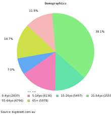
Population and demographics
| Year | Population | Notes |
|---|---|---|
| 1933 | 1,215 | |
| 1947 | 1,423 | |
| 1954 | 1,947 | |
| 1961 | 2,466 | |
| 1966 | 2,960 | |
| 1971 | 3,830 | |
| 1976 | 5,588 | |
| 1981 | 7,934 | |
| 1986 | 11,220 | |
| 1991 | 22,178 | |
| 1996 | 30,702 | |
| 2001 | 33,230 | |
| 2006 | 37,085 | |
| 2011 | 59,052 | [1] |
75.3% of people living in Caboolture were born in Australia. The other top responses for country of birth were New Zealand 4.1%, England 3.7%. 86.2% of people spoke only English at home.
Transport
Caboolture is a regional transport hub. With its connections across the Great Dividing Range via the D'Aguilar Highway, easy highway access to Brisbane and the Sunshine Coast via the Bruce Highway, and the Bribie Island Road to Bribie Island, it is a focal point for road traffic.
Caboolture railway station is the terminus for QR Citytrain's Caboolture railway line, as well as being a major stop on the North Coast railway line. Citytrain operates regular services to Brisbane, in addition to interurban services to Nambour and Gympie, with significant expansion of services north of Caboolture planned over the next decade. The area is serviced by two bus companies, Caboolture Bus Lines and the larger Kangaroo Bus Lines.
Caboolture also contains its own airfield, which primarily services general and recreational aviation. Visiting aircraft are able to operate into the Caboolture airstrip, which is under the operational control of the Caboolture Aero Club Inc. Additionally the airport is home to a number of aviation enterprises and attractions - amongst them, the Caboolture Warplane Museum (with operational P-51 Mustang, CAC Wirraway and CAC Winjeel aircraft), skydiving club, and the Beaufort Restoration group (a group of volunteers restorating an Australian-built DAP Beaufort Mark VII Bomber).
Sport
Caboolture is a strong sporting town with rugby league and cricket teams having strong support. Caboolture also hosts the yearly Australian Golden Gloves amateur boxing tournament at the end of August. The Caboolture Football Club has a strong community base. The club had the most winners on grand final day 2010 in the Sunshine Coast League. The Caboolture Snakes rugby league team holds the most annual titles, and also won the best rugby league club in Queensland 3 years in a row. The town also has a little Athletics club, and is one of the largest in the region and is home to the Queensland State Equestrian Centre (QSEC).
Education
Schools in Caboolture include Caboolture State School near the CBD, Minimbah State School, Tullawong State School, Caboolture East Primary School, Saint Paul's Lutheran Private College and Australian Christian College - Moreton. High Schools include Caboolture State High School, Morayfield State High School, St Columban's College, Caboolture, Tullawong State High School and Caboolture Montessori School to name a few.
Governance
Caboolture was for most of its history the council seat of the Shire of Caboolture, however, the Shire merged into the Moreton Bay Region following statewide local government reforms in March 2008. Caboolture is divided between the electoral districts of Pumicestone and Morayfield in the Legislative Assembly of Queensland, and forms the main part of the Division of Longman in the Australian House of Representatives
Notable people
- Paul Aiton, a Papua New Guinea rugby league captain
- Glen Boss, a jockey who has won the Melbourne Cup three times
- Peter Kelly, a winemaker
- Andrew Lofthouse, a newsreader
- Rod Pampling, a PGA Tour professional golfer
- Keith Urban, a singer who was born in New Zealand, and moved to Caboolture, aged two years
References
| Wikimedia Commons has media related to Caboolture, Queensland. |
- 1 2 3 Australian Bureau of Statistics (31 October 2012). "Caboolture (SA3)". 2011 Census QuickStats. Retrieved 7 October 2015.
- ↑ Macquarie Dictionary, Fourth Edition (2005). Melbourne, The Macquarie Library Pty Ltd. ISBN 1-876429-14-3
- ↑ www.urbancountry.com.au
- ↑ South East Queensland - Place Names 2 January 2006
- 1 2 History of our towns | Caboolture Shire Council
- ↑ Premier Postal History. "Post Office List". Premier Postal Auctions. Retrieved 10 May 2014.
- ↑ "Lagoon Creek Railway Water Supply Facility and Pump Station (entry 602236)". Queensland Heritage Register. Queensland Heritage Council. Retrieved 11 July 2013.
| Topics | ||
|---|---|---|
| Regions | ||
| Cities and towns | ||
| ||