Quinebaug River
| Quinebaug River | |
| River | |
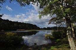 The river in Thompson, CT | |
| Country | United States |
|---|---|
| States | Connecticut, Massachusetts |
| Counties | New London, CT, Windham, CT, Worcester, MA, Hampden, MA |
| Tributaries | |
| - left | French River |
| Source | Holland Pond |
| - location | Holland, Hampden County, Massachusetts, United States |
| - elevation | 645 ft (197 m) |
| Mouth | Empties into Shetucket River |
| - location | Preston and Lisbon, New London County, Connecticut, United States |
| - elevation | 30 ft (9 m) |
| Discharge | for Jewett City, CT |
| - average | 467 cu ft/s (13 m3/s) |
| - max | 2,640 cu ft/s (75 m3/s) Annual mean, 1938 |
| - min | 40 cu ft/s (1 m3/s) Annual mean, 1931 |
_map.jpg)
For the river from New Haven, CT: Quinnipiac River

The Quinebaug River is a river in south-central Massachusetts and eastern Connecticut, with watershed extending into western Rhode Island. The name "Quinebaug" comes from the southern New England Native American term, spelled variously Qunnubbâgge, Quinibauge, etc., meaning "long pond", from qunni-, "long", and -paug, "pond".[1] The river is one of the namesake rivers in the Quinebaug and Shetucket Rivers Valley National Heritage Corridor.
Course
The river is about 69 miles (111 km) in length.[2] It originates from East Brimfield Lake and ponds northwest of Sturbridge, Massachusetts, flows generally southeast and south through Connecticut (Putnam, Danielson, Plainfield, Canterbury and Jewett City), the river joins Aspinook pond which begins in Canterbury and ends in Jewett City. The river then continues to the Shetucket River northeast of Norwich. That river flows from there into the Thames River and drains into the Long Island Sound. It is dammed in its upper reaches at East Brimfield Dam, Westville Dam, and West Thompson Dam all for flood control, as well as numerous mill dams which powered mills along the river's course. Some of these still provide hydroelectric power today.
Watershed
The Quinebaug River watershed covers 850 square miles (2,200 km2), and extends into western Rhode Island. It is heavily forested with 29 named streams including six major tributaries (the French, Moosup and Five Mile Rivers, and the Wales, Mill and Cady brooks). The watershed also contains 54 lakes and ponds, 31 of which with an area of 10 acres (40,000 m2) or more, for a total of about 3,000 acres (12 km²); the largest is East Brimfield Reservoir in Brimfield and Sturbridge (420 acres (1.7 km2)). The watershed is home to fish species including trout, smallmouth bass, largemouth bass, northern pike, and panfish. Elevations range from 1,264 feet (385 m) above sea level on Mount Pisgah in Wales, Massachusetts, to about 25 ft (7.6 m) in Norwich, Connecticut.
Crossings
| State | County | Town | Carries | Built |
|---|---|---|---|---|
| CT | New London | Lisbon and Griswold | Providence and Worcester Railroad | |
| 1956 | ||||
| Silvandale Road crossing (abandoned) | ||||
| Windham | Canterbury | Providence and Worcester Railroad | ||
| Butts Bridge Road | ||||
| Canterbury and Plainfield | ||||
| Brooklyn and Plainfield | ||||
| Brooklyn and Killingly | ||||
| Pomfret and Killingly | ||||
| Cotton Bridge Road | ||||
| Putnam | Landfill access bridge (private) | |||
| Airline Rail Trail | ||||
| Bridge Street | ||||
| Thompson | West Thompson Road | 1964 | ||
| Blain Road (bridge removed) | ||||
| Red Bridge Road | 1964 | |||
| Brickyard Road | 1964 | |||
| Fabyan Road | 1999 | |||
| MA | Worcester | Dudley | ||
| Southbridge Branch RR (abandoned) | ||||
| West Dudley Road | ||||
| Southbridge | East Main Street | |||
| AO Factory Road (private) | ||||
| AO Factory Pedestrian Bridge (private) | ||||
| AO Factory Pedestrian Bridge (private) | ||||
| AO Factory Pedestrian Bridge (private) | ||||
| Pipeline crossing | ||||
| Business Park Road (Private) | ||||
| 1956 | ||||
| Central Street | ||||
| River Street | ||||
| Mill Street | 1956 | |||
| Sturbridge and Southbridge | Westville Dam service road | 2003 | ||
| Breakneck Road/Wallace Road | 1956 | |||
| Sturbridge | Old Mashapaug Road | 1956 | ||
| Grand Trunk Rail Trail | 2002 | |||
| Farquhar Road | 1939 | |||
| Haynes Street | 1961 | |||
| 1971 | ||||
| Old Sturbridge Village Road | 1972 | |||
| OSV Pedestrian Bridge (Private) | ||||
| OSV Covered Bridge (Private) | ||||
| Stallion Hill Road | 1956 | |||
| Holland Road | 1956 | |||
| Hampden | Brimfield | Holland-East Brimfield Road | 1958 | |
| Holland | Morse Road (closed) | 1939 | ||
| Pond Bridge Road | 1934 |
Paddling the River
Three sections of the Quinebaug River have been designated as a National Recreation Trail by the National Park Service, of the first water trails to receive this designation. The sections are: Holland Pond to East Brimfield Reservoir (in Holland and Brimfield, Massachusetts), Paper Mill Dam in Dudley to West Thompson Lake, and Simonzi Park in Putnam to Aspinook Pond in Canterbury. The East Coast Greenway runs along the river in some spots.
Canoe/Kayak launch sites are located at the following locations:
- Pond Bridge Road, Holland
- US Route 20 boat ramp, Brimfield
- Old Mashapaug Road, Sturbridge
- West Dudley Road, Dudley
- Fabyan Road, Thompson
- West Thompson Lake boat ramp, Thompson
- Simonzi Park on Kennedy Drive, Putnam
- Route 101, Pomfret
- Riverside Park off Day Street, Brooklyn
- Town Park off Route 12, Killingly
- Quinebaug Trout Hatchery, Plainfield
- Robert Manship Park off Route 14, Canterbury
- Butts Bridge Road, Canterbury
Gallery
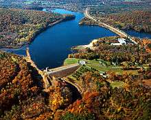 Brimfield Lake and Dam on the Quinebaug River in Hampden County, Massachusetts
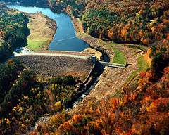 Westville Lake and Dam on the Quinebaug River in Worcester County, Massachusetts
See also
References
- ↑ Bright, William (2004). Native American placenames of the United States. University of Oklahoma Press. p. 405. ISBN 978-0-8061-3598-4. Retrieved 14 April 2011.
- ↑ U.S. Geological Survey. National Hydrography Dataset high-resolution flowline data. The National Map Archived 2012-04-05 at WebCite, accessed April 1, 2011
- Environmental Protection Agency
- USGS Quinebaug River Drainage Basin
- Massachusetts Department of Environmental Protection
- Rhode Island Watershed Partnership
- Columbia Gazetteer of North America