Rabbit Ears Pass
| Rabbit Ears Pass | |
|---|---|
|
View of Rabbit Ears Peak from the Pass | |
| Elevation | 2,873 m (9,426 ft)[1][2] |
| Traversed by |
|
| Location | Grand / Routt counties, Colorado, United States |
| Range | Rocky Mountains |
| Topo map | Terraserver map |
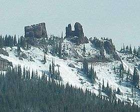
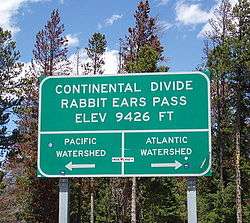
Rabbit Ears Pass (el. 9426 ft, 2873 m) is a high mountain pass in the Rocky Mountains of northern Colorado in the United States. The summit has the shape of rabbit ears, hence the name.[3]
The pass straddles the Continental Divide at the southern end of the Park Range on the boundary between Grand and Routt counties. The name is taken from nearby Rabbit Ears Peak, a mountain in the Park Range to the north that is prominently visible from the east side of the pass during good weather. The pass separates the upper basin of the Yampa River on the west from North Park and the upper basin of the North Platte River on the east. U.S. Highway 40 travels over the pass between Steamboat Springs and Kremmling; this is one of three crossings of the Continental Divide along the highway, along with nearby Muddy Pass to the southeast and the much higher Berthoud Pass closer to Denver.
Somewhat unusually, the highway over Rabbit Ears Pass has a gently rolling character in the vicinity of the summit. After crossing the Divide westbound, the road dips briefly and then reaches its highest point (about 9520 ft) before descending gently to the west summit (9400 ft) and then dropping steeply (7%) toward Steamboat Springs. There is a single runaway truck ramp on this last stretch for truckers whose brakes become hot while descending the grade. The highway is significantly less steep on the eastern side of the pass, where it descends along a slow incline towards Muddy Pass.
Although lower in elevation than many of the high mountain passes farther to the south in the Colorado Rockies, Rabbit Ears Pass often receives a great deal of snow in winter and is subject to regular short closures during heavy winter storms. The meadows beneath it along U.S. 40 allow for reliable cross country skiing.
The current crossing of the Divide represents a realignment of the highway from a somewhat higher crossing just to the north. Access to Old Rabbit Ears Pass can be achieved by turning north off U.S. 40 toward Dumont Lake. The old summit is marked with a stone monument. The old highway is now Grand County Road 199. From the old summit, it is easy to reach the base of Rabbit Ears Peak via 4x4 trails.
References
- ↑ "Rabbit Ears Pass - Routt National Forest".
- ↑ http://www.uncovercolorado.com/Pictures/National-Lands/Rabbit-Ears-Pass/2012-08-18-Rabbit-Ears13.JPG
- ↑ Dawson, John Frank. Place names in Colorado: why 700 communities were so named, 150 of Spanish or Indian origin. Denver, CO: The J. Frank Dawson Publishing Co. p. 42.
External links
Coordinates: 40°23′05″N 106°36′42″W / 40.38472°N 106.61167°W