Raccoon Township, Gallia County, Ohio
| Raccoon Township, Gallia County, Ohio | |
|---|---|
| Township | |
|
Wood Old Homestead, the Bob Evans Farm | |
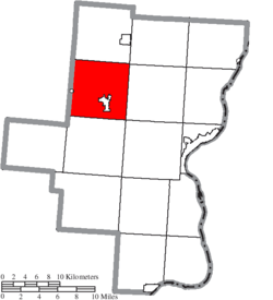 Location of Raccoon Township in Gallia County | |
| Coordinates: 38°53′50″N 82°23′7″W / 38.89722°N 82.38528°WCoordinates: 38°53′50″N 82°23′7″W / 38.89722°N 82.38528°W | |
| Country | United States |
| State | Ohio |
| County | Gallia |
| Area | |
| • Total | 37.7 sq mi (97.5 km2) |
| • Land | 37.3 sq mi (96.6 km2) |
| • Water | 0.4 sq mi (0.9 km2) |
| Elevation[1] | 669 ft (204 m) |
| Population (2000) | |
| • Total | 2,302 |
| • Density | 61.7/sq mi (23.8/km2) |
| Time zone | Eastern (EST) (UTC-5) |
| • Summer (DST) | EDT (UTC-4) |
| FIPS code | 39-65228[2] |
| GNIS feature ID | 1086144[1] |

Raccoon Township is one of the fifteen townships of Gallia County, Ohio, United States. The 2000 census found 2,302 people in the township, 1,253 of whom lived in the unincorporated portions of the township.[3]
Geography
Located in the northwestern part of the county, it borders the following townships:
- Huntington Township - north
- Morgan Township - northeast corner
- Springfield Township - east
- Green Township - southeast corner
- Perry Township - south
- Madison Township, Jackson County - west
- Bloomfield Township, Jackson County - northwest corner
Raccoon Creek forms its eastern border.
Two villages are located in Raccoon Township: Centerville, the smallest village in the county, in the west; and Rio Grande, the second largest village in the county, in the south.
Name and history
It is the only Raccoon Township statewide.[4]
Raccoon Township was organized in 1806. In 1833, the township contained four gristmills, four saw mills, two carding machines, a fulling mill, and two distilleries.[5]
Government
The township is governed by a three-member board of trustees, who are elected in November of odd-numbered years to a four-year term beginning on the following January 1. Two are elected in the year after the presidential election and one is elected in the year before it. There is also an elected township fiscal officer,[6] who serves a four-year term beginning on April 1 of the year after the election, which is held in November of the year before the presidential election. Vacancies in the fiscal officership or on the board of trustees are filled by the remaining trustees.
References
- 1 2 "US Board on Geographic Names". United States Geological Survey. 2007-10-25. Retrieved 2008-01-31.
- ↑ "American FactFinder". United States Census Bureau. Retrieved 2008-01-31.
- ↑ Gallia County, Ohio — Population by Places Estimates Ohio State University, 2007. Accessed 15 May 2007.
- ↑ "Detailed map of Ohio" (PDF). United States Census Bureau. 2000. Retrieved 2007-02-16.
- ↑ Kilbourn, John (1833). "The Ohio Gazetteer, or, a Topographical Dictionary". Scott and Wright. p. 386. Retrieved 12 December 2013.
- ↑ §503.24, §505.01, and §507.01 of the Ohio Revised Code. Accessed 4/30/2009.
External links
Municipalities and communities of Gallia County, Ohio, United States | ||
|---|---|---|
| Villages |  | |
| Townships | ||
| CDP | ||
| Unincorporated communities | ||