Ramea
| Ramea | |
|---|---|
| Town | |
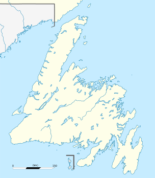 Ramea Location of Ramea in Newfoundland | |
| Coordinates: 47°31′10.29″N 57°24′04.28″W / 47.5195250°N 57.4011889°W | |
| Country |
|
| Province |
|
| Census division | 3 |
| Settled | c. 1805 |
| Incorporated (town) | March 20, 1951 |
| Government | |
| • Mayor | Clyde Dominie |
| • MHA | Andrew Parsons (Burgeo and La Poile) |
| • MP | Judy Foote (Random—Burin—St. George's) |
| Area | |
| • Total | 1.89 km2 (0.73 sq mi) |
| Population (2011)[1] | |
| • Total | 526 |
| Time zone | Newfoundland Time (UTC-3:30) |
| • Summer (DST) | Newfoundland Daylight (UTC-2:30) |
| Postal Code | A0N 2J0 |
| Area code(s) | 709 |
| Highways |
Highway 480 Ferry |
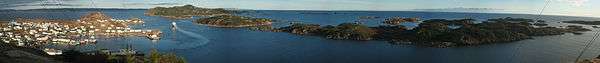
Ramea, Newfoundland and Labrador (NST) is a small village located on Northwest Island, one of a group of five major islands located off the south coast of Newfoundland, Canada. The island is approximately 3.14 km long by 0.93 km wide. (1.95 miles by 0.58 miles) The remaining major islands in the archipelago are Great (or Big) Island, Middle Island, Harbour Island, and South West Island.[2]
History
The community, originally settled in the early 19th century for its proximity to rich fishing grounds and safe anchorages, was once a thriving fishing village. The town of Ramea was incorporated in 1951.[3] Since the cod moratorium of 1992, the isolated community has struggled to survive, having declined to about 50% of its peak population of 1,120 in the 1970s.
Culture
| Population in 2001 | 754 |
| Population change from 1996 | -30.2% |
| Median age | 42.1 |
| Number of families | 255 |
| Number of married couples | 185 |
| Total number of dwellings | 290 |
| Catholic | 0.1% |
| Protestant | 98.7% |
| Land Area (km2.) | 1.89 |
Statistics Canada detail demographics follow link here
2009 was Ramea Come Home Year
Flora and fauna
Ramea is home to a large number of plants, which include the purple pitcher plant and bakeapple. Furthermore, the island and surrounding islands serve as a fall and winter home to many migratory seabirds.
Activities
There are a number of walks on the island. The walk also includes the wind-diesel plant.
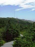
Walking to the island's highest point on top of Man O'War Hill offers excellent views of archipelago and across to White Bear Bay.
Every year the islands plays host to a traditional music festival on the second weekend of August.
Many people living in the community enjoy hunting different species of seabirds, such as Eider Ducks and Murres (Turres).
Wind energy
In 2004, Ramea was chosen for the site of
Canada's first wind-diesel demonstration project was completed with the support of CETC-Ottawa. Six 65 kW wind turbines were installed on the island of Ramea , Newfoundland . The objective of the project was to demonstrate that the Wind-Diesel Integrated Control System (WDICS) can be used to displace diesel power generation by introducing wind to the island's grid and to show significant energy efficiency and reliability for northern, remote or isolated locations.
CANMET Energy Technology Centre-Ottawa (CETC-Ottawa)
The wind-diesel pilot program generates around 1 million kWh electricity / yr and offsets approximately 750 tonnes of emissions annually.
Ramea was selected as the pilot site[4] for a Wind-Hydrogen power system. The project is being undertaken by Newfoundland and Labrador Hydro in partnership with Natural Resources Canada, Memorial University, University of New Brunswick and Frontier Power Systems.
The wind-hydrogen system is due for completion in April 2010[5]
Neighbouring communities
West - Burgeo East - Grey River
See also
References
- ↑ "Corrections and updates: Population and dwelling count amendments, 2011 Census". Statistics Canada. February 14, 2013. Retrieved February 15, 2013.
- ↑ Ramea Island
- ↑ Ramea - Newfoundland and Labrador
- ↑ Sod Turning for First Commercial Wind Farm in Newfoundland and Labrador
- ↑ http://www.nalcor.org/assets/nalcorenergyrameareport_january2010.pdf
External links
- The Town of Ramea
- Explore Newfoundland and Labrador
- Marital structure and genetic heterogeneity of Ramea Island, Newfoundland
- St Boniface All Grade School
- Eastern Outdoors Kayaking and tourist information centre
- Senior Puffin Museum
Coordinates: 47°31′N 57°23′W / 47.517°N 57.383°W