Channel-Port aux Basques
| Channel-Port aux Basques | |
|---|---|
| Town | |
|
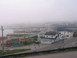
The Channel-Port aux Basques waterfront in October 2005. | |
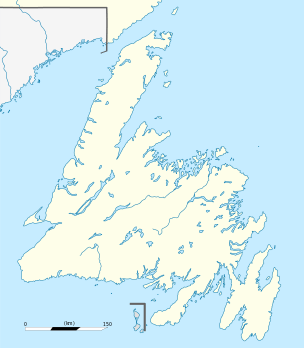 Channel-Port aux Basques Location of Channel-Port aux Basques in Newfoundland | |
| Coordinates: 47°34′10″N 59°08′10″W / 47.56944°N 59.13611°WCoordinates: 47°34′10″N 59°08′10″W / 47.56944°N 59.13611°W | |
| Country |
|
| Province |
|
| Incorporated | 1945 |
| Government | |
| • Type | Channel-Port aux Basques Town Council |
| • Mayor | Ralph Pontillas |
| Area | |
| • Total | 38.77 km2 (14.97 sq mi) |
| Elevation | 23 m (75 ft) |
| Population (2011) | |
| • Total | 4,170 |
| • Density | 111.4/km2 (289/sq mi) |
| Time zone | Newfoundland Time (UTC-3:30) |
| • Summer (DST) | Newfoundland Daylight (UTC-2:30) |
| Postal code span | A0M |
| Area code(s) | 709 |
| Highways |
Route 470 Route 1 |
| Website |
www |
Channel-Port aux Basques is a town at the extreme southwestern tip of Newfoundland fronting on the western end of the Cabot Strait. A Marine Atlantic ferry terminal is located in the town which is the primary entry point onto the island of Newfoundland and the western terminus of the Trans-Canada Highway in the province. The town was incorporated in 1945 and its population in the 2011 census was 4,170.[1]
Port aux Basques is the oldest of the collection of towns that make up the present-day town, which consists of Port aux Basques, Channel, Grand Bay, and Mouse Island. Amalgamation took place in the 1970s.
History
Channel refers to the narrow channel of water that leads into the local harbour. Port aux Basques refers to the harbour that was a favoured sheltering and watering place for Basque whalers who hailed from the Basque region of the Pyrenees of France and Spain during the early 16th century. After leaving the harbour the whalers either proceeded to the main whaling grounds off southern Labrador, or headed home to the Basque country. They almost certainly took on fresh water from Dead Man's Brook, which flows into Port aux Basques harbour, during their stopovers.
Port aux Basques is first seen on a 1687 Johannes van Keulen map of the area. Permanent settlement came from French fishermen who overwintered on this, the "French shore", using rights given under the 1713 Treaty of Utrecht which saw France cede its claims in Newfoundland to Great Britain in exchange for right of use of coastal lands for the fishery. With the fishery being the economic mainstay for both French and British settlers in the area, Channel-Port aux Basques appeared destined to remain a collection of small fishing villages.
The town is called "Siinalk" in the Mi'kmaq language.
Telegraph cable
In 1856, an underwater telegraph cable was successfully laid between Newfoundland and Cape Breton Island, making landfall nearby. This was the first step in the race to complete a trans-Atlantic telegraph cable. A telegraph station was opened in Port aux Basques in 1857.
Demographics
| Historical population | ||
|---|---|---|
| Year | Pop. | ±% |
| 1951 | 2,634 | — |
| 1956 | 3,320 | +26.0% |
| 1961 | 4,141 | +24.7% |
| 1981 | 6,105 | +47.4% |
| 1986 | 5,901 | −3.3% |
| 1991 | 5,644 | −4.4% |
| 1996 | 5,243 | −7.1% |
| 2001 | 4,637 | −11.6% |
| 2006 | 4,319 | −6.9% |
| 2011 | 4,170 | −3.4% |
| [2][3][4][5][6][7][8] Population figures reflect the town's amalgamation in the 1970s. | ||
| Canada 2006 Census | Population | % of Total Population | |
|---|---|---|---|
| Visible minority group Source:[9] | South Asian | 35 | 0.8% |
| Chinese | 0 | 0% | |
| Black | 0 | 0% | |
| Filipino | 0 | 0% | |
| Latin American | 0 | 0% | |
| Arab | 0 | 0% | |
| Southeast Asian | 0 | 0% | |
| West Asian | 0 | 0% | |
| Korean | 0 | 0% | |
| Japanese | 0 | 0% | |
| Other visible minority | 0 | 0% | |
| Mixed visible minority | 0 | 0% | |
| Total visible minority population | 35 | 0.8% | |
| Aboriginal group Source:[10] | First Nations | 20 | 0.5% |
| Métis | 0 | 0% | |
| Inuit | 0 | 0% | |
| Total Aboriginal population | 20 | 0.5% | |
| White | 4,205 | 98.7% | |
| Total population | 4,260 | 100% | |
Transportation
Both the Trans-Canada Highway and the Trans-Canada Trail have their Newfoundland and Labrador start and end points in Port aux Basques.
Railway
In the 1880s, the Government of Canada erected a lighthouse at nearby Cape Ray which, despite being in the then-separate British colony of Newfoundland, was considered a navigation hazard for vessels bound for Canadian ports in the Gulf of St. Lawrence.
In 1893, it was decided to extend the western terminus of the Newfoundland Railway (then under construction west from the Avalon Peninsula by Robert G. Reid) from St. George's to Port aux Basques harbour. By 1897 the tracks reached Port aux Basques, although the harbour facilities had not been built at that time to handle the steamer Bruce, which had been built in Scotland and had arrived in Newfoundland several months earlier. While the required docks were constructed, the Bruce operated between Little Placentia Sound and North Sydney, Nova Scotia from October, 1897 until June, 1898 .
Air service
Port Aux Basques is served by air via Stephenville International Airport, located 145 kilometres north of the town. Regular domestic air service is provided by Provincial Airlines year round, while Sunwing provides service to Toronto's Pearson International Airport from May to October, and Air Saint-Pierre offers summer service to the French colonies off Newfoundland's south coast.
Ferries
On June 30, 1898, the first passenger train arrived in Port aux Basques, and Bruce departed for North Sydney shortly afterward. Over the years, the Newfoundland Railway expanded both the number of trains and vessels which called at Port Aux Basques. In 1925 the steamer SS Caribou began service. She was attacked and sunk by the German submarine U-69 (1940) on 14 October 1942 with a loss of 137 lives, some from the Port aux Basques area. There were 20 widows from Caribou sinking in the Port aux Basques area.
The Town of Port aux Basques was incorporated in 1945 with Samuel (Sam) Walters as the first mayor.
On 31 March 1949 Newfoundland entered into Confederation and the railway was transferred to Canadian National Railways. Under Term 32 of the Terms of Union between Canada and Newfoundland (1949), the ferry service between North Sydney, Nova Scotia and Port aux Basques, Newfoundland was guaranteed, first under the British North America Act and after 1982 under the Constitution of Canada.
Upon CNR's assumption of the railway and ferry service, the 1950s saw extensive construction at Port aux Basques with expansion of new dock facilities and the arrival of newer and larger ships such as the MV William Carson. Extensive blasting of rock created space for large rail yards with extensive dual gauge trackage. The excess rock was then used as fill to create the required docks. By the mid-1960s, new railcar-capable ferries such as the MV Frederick Carter permitted the exchange of standard gauge railcars, requiring further expansion at the Port aux Basques terminal facilities.
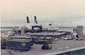
The mid-1960s also saw the completion of the Trans-Canada Highway across Newfoundland, an event which eventually led to the closure of the railway by 1988, but which made Port aux Basques into an even more important gateway to the island of Newfoundland, given the increased number of tourists visiting the province, and the rising amount of truck traffic. New Ro-Pax-capable vessels were commissioned and/or chartered during the 1960s-1980s to meet the growing demand, such as Marine Nautica, Marine Atlantica, Marine Evangeline, Ambrose Shea, and John Hamilton Gray.
With the abandonment of the railway, extensive rebuilding of Port aux Basques terminal resulted in expansive marshaling areas for waiting motor vehicle traffic. A plant disease inspection station operated by the Canadian Food Inspection Agency is located on site, as well as a modern rebuilt railway station now used as a passenger terminal for the ferry service operated by Marine Atlantic, which was renamed from CN Marine in 1986. Port aux Basques harbour used to host the arrival of the two largest icebreaking ferries in Canada at the time, the MV Caribou and MV Joseph and Clara Smallwood both of which were retired and decommissioned in 2011.
In 2009, a larger and more modern vessel, the MV Atlantic Vision, was added to the fleet. With a larger carrying capacity and an equivalent Ice Class to the MV Caribou, the MV Atlantic Vision was introduced as the new flagship for Marine Atlantic.[11] Following the retirement of the MV Caribou and the MV Joseph and Clara Smallwood, two more new ships were acquired on a 5-year charter from Stena Line. These two new ships, the MV Blue Puttees and MV Highlanders currently round out the Marine Atlantic Fleet. Marine Atlantic announced in May 2015 that it would be purchasing both ships for C$100 Million each.[12]
College of the North Atlantic
The Port aux Basques campus of the College of the North Atlantic first opened as the District Vocational School in September 1963. The school was constructed by M.R. Chappell of Nova Scotia because Lundrigan's Ltd of Corner Brook, who was constructing the other District Vocational Schools in Newfoundland, couldn't move their equipment and supplies over the uncompleted road from Corner Brook to Port aux Basques. The Trans-Canada Highway from Corner Brook to Port aux Basques was completed in 1965.
Climate
Channel-Port aux Basques experiences a marine-influenced subarctic climate (Dfc).
| Climate data for Channel-Port aux Basques | |||||||||||||
|---|---|---|---|---|---|---|---|---|---|---|---|---|---|
| Month | Jan | Feb | Mar | Apr | May | Jun | Jul | Aug | Sep | Oct | Nov | Dec | Year |
| Record high °C (°F) | 9.9 (49.8) |
8.9 (48) |
11.2 (52.2) |
15.6 (60.1) |
22.2 (72) |
25 (77) |
27.8 (82) |
27.2 (81) |
30 (86) |
25 (77) |
15 (59) |
10.6 (51.1) |
30 (86) |
| Average high °C (°F) | −1.5 (29.3) |
−2.6 (27.3) |
−0.1 (31.8) |
3.5 (38.3) |
7.9 (46.2) |
12.3 (54.1) |
16.3 (61.3) |
17.9 (64.2) |
14.8 (58.6) |
10 (50) |
5.6 (42.1) |
1 (34) |
7.1 (44.8) |
| Daily mean °C (°F) | −4.5 (23.9) |
−5.8 (21.6) |
−3 (27) |
1 (34) |
5 (41) |
9.2 (48.6) |
13.5 (56.3) |
14.8 (58.6) |
11.5 (52.7) |
7 (45) |
3 (37) |
−1.7 (28.9) |
4.2 (39.6) |
| Average low °C (°F) | −7.6 (18.3) |
−9.1 (15.6) |
−6 (21) |
−1.6 (29.1) |
2 (36) |
6.1 (43) |
10.6 (51.1) |
11.7 (53.1) |
8.2 (46.8) |
4 (39) |
0.4 (32.7) |
−4.6 (23.7) |
1.2 (34.2) |
| Record low °C (°F) | −23.3 (−9.9) |
−26.1 (−15) |
−24.1 (−11.4) |
−13.3 (8.1) |
−6.7 (19.9) |
−1.1 (30) |
4.4 (39.9) |
2.8 (37) |
0 (32) |
−4 (25) |
−10.6 (12.9) |
−21.2 (−6.2) |
−26.1 (−15) |
| Average precipitation mm (inches) | 142.6 (5.614) |
112.4 (4.425) |
105.5 (4.154) |
113.4 (4.465) |
119.2 (4.693) |
113.7 (4.476) |
106.3 (4.185) |
121.4 (4.78) |
115 (4.53) |
146.1 (5.752) |
153.7 (6.051) |
172.1 (6.776) |
1,521.5 (59.902) |
| Source: 1961-1990 Environment Canada [13] | |||||||||||||
Sports
Port aux Basques placed 2nd in the top 5 communities for Hockeyville 2008, and won $20,000 for its local arena. Its sports arena, Bruce I, burned down in 1995, just prior to the hockey season. It was located on top of Army Hill on a road named Stadium Road down in Channel. The new arena, Bruce II Sports Centre, was opened on November 23, 1996.
See also
References
- ↑ Population and dwelling counts
- ↑ 140.pdf, Canada Year Book 1955
- ↑ 126.pdf, Canada Year Book 1957-58
- ↑ "Archived copy" (PDF). Archived from the original (PDF) on 2014-12-23. Retrieved 2014-08-30., Canada Year Book 1967
- ↑ , E-STAT Table
- ↑ , Canada 1996 Census
- ↑ , Canada 2006 Census
- ↑ , Canada 2011 Census
- ↑ aux Basques&SearchType=Begins&SearchPR=01&B1=All&Custom=, Community Profiles from the 2006 Census, Statistics Canada - Census Subdivision
- ↑ , Aboriginal Peoples - Data table
- ↑ "Marine Atlantic renews lease for MV Atlantic Vision". CBC News. 2015-02-03. Retrieved 2015-10-26.
- ↑ "Marine Atlantic Purchases MV Blue Puttees, MV Highlanders". CBC News. 2015-05-26. Retrieved 2015-05-26.
- ↑ Environment Canada—1961–1990. Retrieved 15 October 2012.
External links
| Wikivoyage has a travel guide for Port aux Basques. |
| Wikimedia Commons has media related to Channel-Port aux Basques. |
- Channel - Port aux Basques
- U-69 submarine
- Song - Dear Old Port aux Basques by native son David Blackmore
 |
Division No. 3, Subd. H | | ||
| Gulf of St. Lawrence | |
Division No. 3, Subd. H | ||
| ||||
| | ||||
| Cabot Strait |
| Census divisions | |
|---|---|
| Cities | |
| Other communities |
|
| |