Ranch to Market Road 337
| ||||
|---|---|---|---|---|
| Route information | ||||
| Maintained by TxDOT | ||||
| Length: | 56.1 mi[1] (90.3 km) | |||
| Existed: | 1945 – present | |||
| Major junctions | ||||
| West end: |
| |||
|
| ||||
| East end: |
| |||
| Location | ||||
| Counties: | Real, Bandera | |||
| Highway system | ||||
| ||||

Ranch to Market Road 337 or RM 337 is a Texas state road that runs from Camp Wood east to Medina. The route was designated in 1945 between Camp Wood and Leakey in Real County, but was gradually extended eastward over the years until in 1968 it stretched to RM 187 at Vanderpool in Bandera County. In 1976, an additional 9.7 miles (15.6 km) were added east from RM 187 to connect to SH 16 in Medina, bringing the road to its present form.[2]
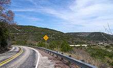
Passing through the canyonland of the Texas Hill Country northwest of San Antonio, RM 337 is renowned for its hairpin switchbacks[3] and extreme natural beauty; it has been called one of the most scenic drives in Texas.[4][5][6] Texas Monthly magazine named the road no. 18 on its list of "75 Things We Love About Texas" in its April 2006 issue.[7]
History
Ranch to Market Road 337 was first designated on June 11, 1945, traveling from Camp Wood to Leakey. On December 1, 1957, it was extended 6.5 miles (10.5 km) eastward, and on September 27 of 1960, the route was extended another 3 miles (4.8 km) eastward. On November 1, 1968, the highway was extended eastward to an intersection with RM 187. On February 16, 1976, FM 1336 from SH 16 west 9.8 miles was added to the length of RM 337, adding 9.8 miles (15.8 km) to the route. In addition, 9.7 miles were added from RM 187 to the end of FM 1336.[1]
Junction list
| County | Location | mi[8] | km | Destinations | Notes |
|---|---|---|---|---|---|
| Real | Camp Wood | 0.000 | 0.000 | Western Terminus | |
| Leakey | 21.314 | 34.302 | |||
| Bandera | Vanderpool | 36.517 | 58.768 | North end of RM 187 concurrency | |
| 37.716 | 60.698 | South end of RM 187 concurrency | |||
| Medina | 56.101 | 90.286 | Eastern Terminus | ||
1.000 mi = 1.609 km; 1.000 km = 0.621 mi
| |||||
References
- 1 2 Transportation Planning and Programming Division (n.d.). "Ranch to Market Road No. 337". Highway Designation Files. Texas Department of Transportation. Retrieved October 29, 2012.
- ↑ Google (March 11, 2012). "Overview map of Ranch to Market Road 337" (Map). Google Maps. Google. Retrieved March 11, 2012.
- ↑ Burka, Paul (April 1983). "Texas Primer: The Farm-to-Market Road". Texas Monthly. Retrieved 2011-08-06.
- ↑ "Texas' Top Ten Roads". Retrieved 2008-08-26.
- ↑ Hodge, Larry; Syers, Ed (2000). "Backroads of Texas" (4th ed.). Lanham, MD: Lone Star Books.
- ↑ "A Sunday Drive in the Texas Hill Country". Retrieved 2008-08-26.
- ↑ "Bandera, Texas - Visitor & Real Estate Guide to Bandera, Texas". Retrieved 2008-08-26.
- ↑ Statewide Planning Map (Map). Cartography by Transportation Planning and Programming Division. Texas Department of Transportation. 2012. Retrieved January 22, 2013.