Leakey, Texas
| Leakey, Texas | |
|---|---|
| City | |
|
Real County Courthouse in Leakey | |
 Location of Leakey, Texas | |
 | |
| Coordinates: 29°43′31″N 99°45′41″W / 29.72528°N 99.76139°WCoordinates: 29°43′31″N 99°45′41″W / 29.72528°N 99.76139°W | |
| Country | United States |
| State | Texas |
| County | Real |
| Area | |
| • Total | 0.6 sq mi (1.4 km2) |
| • Land | 0.6 sq mi (1.4 km2) |
| • Water | 0.0 sq mi (0.0 km2) |
| Elevation | 1,604 ft (489 m) |
| Population (2010) | |
| • Total | 425 |
| • Density | 703.8/sq mi (273.48/km2) |
| Time zone | Central (CST) (UTC-6) |
| • Summer (DST) | CDT (UTC-5) |
| ZIP code | 78873 |
| Area code | 830 |
| FIPS code | 48-42004[1] |
| GNIS feature ID | 1339757[2] |

Leakey (/ˈleɪki/ LAY-kee[3]) is a city in and the county seat of Real County, Texas, United States.[4] The population was 425 at the 2010 census.
The city is named for John H. Leakey (1824-1900), a pioneer from Tennessee.
Leakey depends heavily on tourism because of the existence of the nearby Frio River and Garner State Park. The Alto Frio Baptist Encampment is located to the southeast of the community.
Geography
Leakey is located at 29°43′31″N 99°45′41″W / 29.725243°N 99.761463°W (29.725243, -99.761463).[5] It is situated at the intersection of U.S. Highway 83, RM 336, RM 337, and FM 1120 in southeastern Real County, approximately 35 miles north of Uvalde and 90 miles northwest of San Antonio.[6]
According to the United States Census Bureau, the city has a total area of 0.6 square miles (1.6 km2), all of it land.
It is in close proximity to the Garner State Park.[7]
History
Archaeological excavations in the Frio Canyon region revealed Paleo-American, Archaic, and Neo-American occupations. Later, several Native American tribes, including Lipan Apache, Comanche, and Tonkawa inhabited or traversed the area.[8]
Anglo-American settlement of the area began in 1856 when John Leakey, his wife Nancy, and a few others settled near a spring along the banks of the Frio River. Shingles and lumber were produced from the abundant cypress and cedar trees. In its first few years, the community was a lonely outpost that was subject to frequent Indian raids, which continued until 1882. Growth accelerated after the Civil War as new families arrived.[9] In 1883, A.G. Vogel moved a post office from the community of Floral to Leakey. That same year, the Texas State Legislature created Edwards County and designated Leakey as the county seat less than a year later.[10] 1883 was also the year that the area's first school was established on land donated by the Leakeys.[11] A new school building was completed in 1890.[10] In 1891, the Edwards County seat was moved from Leakey to Rocksprings.[10] During the early 1900s, ranching superseded lumber, cotton cultivation, and corn production in importance to the local economy. The raising of Angora goats was a major component of the ranching industry. In 1902, the school in Leakey had a total enrollment of 102 students.[10] The town's population was estimated to be 318 in 1904.
Real County was created from parts of Edwards, Bandera, and Kerr Counties in the spring of 1913, with Leakey as the county seat.[12] In 1919, Real County Judge Ed Kelly established the Leakey Independent School District.[10][11] By the mid-1920s, the population had declined to around 120.[6] A larger school building was completed in 1930. Soon after, several nearby schools, including West Frio, Cypress Creek, Rio Frio, Exile, Stanford, Dry Frio, and Harper were consolidated with Leakey schools.[11]
Leakey was formally incorporated on June 11, 1951.[8] The population fluctuated during the latter half of the 20th century. Leakey was home to 450 people in 1960, 393 in 1970, 468 in 1980, and 399 in 1990. By 2000, there were 387 residents living in Leakey, representing a 3.01% decrease in population since the last census was conducted in 1990.
Demographics
| Historical population | |||
|---|---|---|---|
| Census | Pop. | %± | |
| 1960 | 587 | — | |
| 1970 | 393 | −33.0% | |
| 1980 | 468 | 19.1% | |
| 1990 | 399 | −14.7% | |
| 2000 | 387 | −3.0% | |
| 2010 | 425 | 9.8% | |
| Est. 2015 | 424 | [13] | −0.2% |
As of the census[15] of 2010, 425 people, 174 households, and 115 families resided in the city. The population density was 708.3 people per square mile (273.48/km2). The 237 housing units averaged 395/mi2 (148.1/km2). The racial makeup of the city was 91.5% White, 0.5% African American, 2.1% Native American, 3.8% from other races. Hispanics or Latinos of any race were 26.4% of the population.
Of the 174 households, 28.1% had children under the age of 18 living with them, 54% were married couples living together, 8.6% had a female householder with no husband present, and 33.9% were not families. About 30.5% of all households were made up of individuals, and 10.3% had someone living alone who was 65 years of age or older. The average household size was 2.44 and the average family size was 2.97.
In the city, the population was distributed as 27.2% under the age of 20, 4.7% from 20 to 24, 23.6% from 25 to 44, 26.6% from 45 to 64, and 17.9% who were 65 years of age or older. The median age was 41.1 years. For every 100 females, there were 84.3 males. For every 100 females age 18 and over, there were 83.4 males.
The median income for a household in the city was $23,125, and for a family was $24,531.
Economy
As of the 1970s, much of its income derived from deer hunters traveling there in the fall and tourists in the summer.[7]
Education
Public education in the city of Leakey is provided by the Leakey Independent School District.
Children also have the option of attending Ed Brune Charter School.
Climate
The climate in this area is characterized by hot, humid summers and generally mild to cool winters. Leakey has a humid subtropical climate, Cfa on climate maps aaccording to the Köppen climate classification system.[16]
References
- ↑ "American FactFinder". United States Census Bureau. Retrieved 2008-01-31.
- ↑ "US Board on Geographic Names". United States Geological Survey. 2007-10-25. Retrieved 2008-01-31.
- ↑ http://www.texastripper.com/pronounce/locations-j-l.html
- ↑ "Find a County". National Association of Counties. Retrieved 2011-06-07.
- ↑ "US Gazetteer files: 2010, 2000, and 1990". United States Census Bureau. 2011-02-12. Retrieved 2011-04-23.
- 1 2 "Leakey, Texas". Texas Escapes Online Magazine. Retrieved 2009-07-06.
- 1 2 "Guthrie, Dana (compiler) and St. Gil, Marc (photographer of the Environmental Protection Agency). "EPA photos of Texas from the 1970s." Houston Chronicle. September 3, 1973. Retrieved on September 7, 2013.
- 1 2 "Leakey, Texas". The Handbook of Texas online. Retrieved 2009-07-03.
- ↑ "Frio Canyon History". Real County, TXGen Web Project. Retrieved 2009-07-06.
- 1 2 3 4 5 "Leakey, TX". Small Town Research Project. Palo Alto College. Retrieved 2009-07-03.
- 1 2 3 "Leakey School". Historical Markers in Leakey. HillCountryRambling.com. Retrieved 2009-07-06.
- ↑ "Real County, Texas". The Handbook of Texas online. Retrieved 2009-07-03.
- ↑ "Annual Estimates of the Resident Population for Incorporated Places: April 1, 2010 to July 1, 2015". Retrieved July 2, 2016.
- ↑ "Census of Population and Housing". Census.gov. Retrieved June 4, 2015.
- ↑ http://factfinder2.census.gov/rest/dnldController/deliver?_ts=375879952115
- ↑ Climate Summary for Leakey, Texas
External links
| Wikimedia Commons has media related to Leakey, Texas. |
- Leakey from the Handbook of Texas Online
- Photos taken of Leakey for the DOCUMERICA project in the 1970s
Gallery
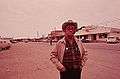 Main Street in Leakey (1972)
 Josh's Frio River Outfitters store in Leakey
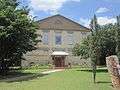
 Frio Canyon Baptist Church is located off U.S. Highway 83 south in Leakey
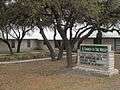 Non-denominational Church in the Valley in Leakey
Municipalities and communities of Real County, Texas, United States | ||
|---|---|---|
| Cities | 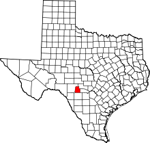 | |
| Unincorporated community | ||
