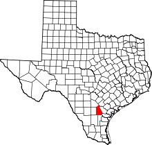
Ray Point, Texas
| Ray Point | |
|---|---|
| rural unincorporated community | |
 Ray Point  Ray Point Location within the state of Texas | |
| Coordinates: 28°30′50″N 98°5′17″W / 28.51389°N 98.08806°WCoordinates: 28°30′50″N 98°5′17″W / 28.51389°N 98.08806°W | |
| Country | United States |
| State | Texas |
| County | Live Oak |
| Population (1990) | |
| • Total | 75 |
| Time zone | Central (CST) (UTC-6) |
| • Summer (DST) | CDT (UTC-5) |
| GNIS feature ID | 1380416[1] |
Ray Point is a small rural unincorporated community in Live Oak County, Texas, United States. It is a German farming community typical for much of Texas. The most prominent remaining structures are the Ray Point community center and the Ray Point Mercantile (closed). Nearby is the Ray Point cemetery. The nearest city is Three Rivers.[2]
Demographics
In 1990 there were 75 people residing in the community according to the Handbook of Texas Online.
References
- ↑ U.S. Geological Survey Geographic Names Information System: Ray Point, Texas
- ↑ "US Gazetteer files: 2010, 2000, and 1990". United States Census Bureau. 2011-02-12. Retrieved 2011-04-23.
External links
- Ray Point, Texas from the Handbook of Texas Online
This article is issued from Wikipedia - version of the 7/30/2016. The text is available under the Creative Commons Attribution/Share Alike but additional terms may apply for the media files.
