Raymond, Washington
| Raymond | |
|---|---|
| City | |
| Raymond, Washington | |
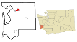 Location of Raymond, Washington | |
| Coordinates: 46°40′47″N 123°44′17″W / 46.67972°N 123.73806°WCoordinates: 46°40′47″N 123°44′17″W / 46.67972°N 123.73806°W | |
| Country | United States |
| State | Washington |
| County | Pacific |
| Area[1] | |
| • Total | 4.62 sq mi (11.97 km2) |
| • Land | 4.06 sq mi (10.52 km2) |
| • Water | 0.56 sq mi (1.45 km2) |
| Elevation | 13 ft (4 m) |
| Population (2010)[2] | |
| • Total | 2,882 |
| • Estimate (2015)[3] | 2,815 |
| • Density | 709.9/sq mi (274.1/km2) |
| Time zone | Pacific (PST) (UTC-8) |
| • Summer (DST) | PDT (UTC-7) |
| ZIP code | 98577 |
| Area code(s) | 360 |
| FIPS code | 53-57430[4] |
| GNIS feature ID | 1507743[5] |
| Website | City of Raymond |
Raymond is a city in Pacific County, Washington, United States. The population was 2,975 at the 2000 census and decreased 3.1% to 2,882 at the 2010 census. The town's economy is based on logging and fishing, together with a limited amount of tourism.
History
Raymond was officially incorporated on August 6, 1907. Raymond was named after L.V. Raymond,[6] who was the first postmaster in Raymond. In the early years, Raymond's business section was built on stilts five or six feet above the tidelands and sloughs that crisscrossed the site. Elevated sidewalks and streets connected most of the buildings. Raymond claimed a population of 6,000 in the year 1913 and had a reputation as a wild and wooly lumber mill town. City fathers resisted the unwanted reputation with promotions of Raymond as "The Empire City of Willapa Harbor" and "The City That Does Things". Lyricist Robert Wells, who wrote "The Christmas Song" with Mel Tormé, was born in Raymond in 1922.[7] Raymond was the city where the grunge band Nirvana played their first gig, on March 7, 1987.[8]
Geography
Raymond is located at 46°40′47″N 123°44′17″W / 46.67972°N 123.73806°W (46.679599, -123.738091).[9]
According to the United States Census Bureau, the city has a total area of 4.62 square miles (11.97 km2), of which, 4.06 square miles (10.52 km2) is land and 0.56 square miles (1.45 km2) is water.[1]
Climate
According to the Köppen Climate Classification system, Raymond has a warm-summer Mediterranean climate, abbreviated "Csb" on climate maps.[10]
| Climate data for Raymond | |||||||||||||
|---|---|---|---|---|---|---|---|---|---|---|---|---|---|
| Month | Jan | Feb | Mar | Apr | May | Jun | Jul | Aug | Sep | Oct | Nov | Dec | Year |
| Record high °F (°C) | 65 (18) |
75 (24) |
79 (26) |
86 (30) |
94 (34) |
97 (36) |
100 (38) |
102 (39) |
99 (37) |
88 (31) |
69 (21) |
63 (17) |
102 (39) |
| Average high °F (°C) | 47.5 (8.6) |
50.4 (10.2) |
54 (12) |
57.9 (14.4) |
62.5 (16.9) |
66.1 (18.9) |
70.8 (21.6) |
72.3 (22.4) |
70 (21) |
60.7 (15.9) |
51.5 (10.8) |
46.1 (7.8) |
59.1 (15.1) |
| Average low °F (°C) | 33.1 (0.6) |
32.6 (0.3) |
35.2 (1.8) |
37.5 (3.1) |
42.6 (5.9) |
47.1 (8.4) |
50.5 (10.3) |
50 (10) |
45.3 (7.4) |
39.6 (4.2) |
35.8 (2.1) |
32.3 (0.2) |
40.1 (4.5) |
| Record low °F (°C) | 5 (−15) |
5 (−15) |
20 (−7) |
24 (−4) |
28 (−2) |
34 (1) |
37 (3) |
35 (2) |
29 (−2) |
17 (−8) |
9 (−13) |
3 (−16) |
3 (−16) |
| Average precipitation inches (mm) | 12.58 (319.5) |
9.2 (234) |
9.67 (245.6) |
6.48 (164.6) |
3.95 (100.3) |
2.88 (73.2) |
1.25 (31.8) |
1.33 (33.8) |
2.69 (68.3) |
7.37 (187.2) |
13.73 (348.7) |
12 (300) |
83.13 (2,111.5) |
| Average snowfall inches (cm) | 0.5 (1.3) |
0 (0) |
0 (0) |
0 (0) |
0 (0) |
0 (0) |
0 (0) |
0 (0) |
0 (0) |
0 (0) |
0.1 (0.3) |
0.3 (0.8) |
1 (3) |
| Average precipitation days (≥ 0.01 inch) | 22 | 18 | 22 | 20 | 17 | 14 | 8 | 8 | 10 | 18 | 23 | 21 | 201 |
| Source: [11] | |||||||||||||
Demographics
| Historical population | |||
|---|---|---|---|
| Census | Pop. | %± | |
| 1910 | 2,450 | — | |
| 1920 | 4,260 | 73.9% | |
| 1930 | 3,828 | −10.1% | |
| 1940 | 4,045 | 5.7% | |
| 1950 | 4,110 | 1.6% | |
| 1960 | 3,301 | −19.7% | |
| 1970 | 3,126 | −5.3% | |
| 1980 | 2,991 | −4.3% | |
| 1990 | 2,901 | −3.0% | |
| 2000 | 2,975 | 2.6% | |
| 2010 | 2,882 | −3.1% | |
| Est. 2015 | 2,815 | [12] | −2.3% |
| U.S. Decennial Census[13] 2015 Estimate[3] | |||
2010 census
As of the census[2] of 2010, there were 2,882 people, 1,151 households, and 698 families residing in the city. The population density was 709.9 inhabitants per square mile (274.1/km2). There were 1,279 housing units at an average density of 315.0 per square mile (121.6/km2). The racial makeup of the city was 75.9% White, 0.9% African American, 2.5% Native American, 6.8% Asian, 10.1% from other races, and 3.9% from two or more races. Hispanic or Latino of any race were 16.2% of the population.
There were 1,151 households of which 29.4% had children under the age of 18 living with them, 42.9% were married couples living together, 10.4% had a female householder with no husband present, 7.3% had a male householder with no wife present, and 39.4% were non-families. 33.4% of all households were made up of individuals and 15.2% had someone living alone who was 65 years of age or older. The average household size was 2.46 and the average family size was 3.10.
The median age in the city was 41 years. 23.4% of residents were under the age of 18; 8.6% were between the ages of 18 and 24; 22.2% were from 25 to 44; 27.5% were from 45 to 64; and 18.4% were 65 years of age or older. The gender makeup of the city was 49.9% male and 50.1% female.
2000 census
As of the census[4] of 2000, there were 2,975 people, 1,192 households, and 760 families residing in the city. The population density was 776.4 people per square mile (299.9/km²). There were 1,338 housing units at an average density of 349.2 per square mile (134.9/km²). The racial makeup of the city was 83.70% White, 0.24% African American, 2.72% Native American, 7.06% Asian, 0.17% Pacific Islander, 3.16% from other races, and 2.96% from two or more races. Hispanic or Latino of any race were 9.18% of the population. 12.0% were of English, 11.6% German, 7.6% Irish, 6.0% American and 5.7% Polish ancestry according to Census 2000.
There were 1,192 households out of which 30.0% had children under the age of 18 living with them, 45.9% were married couples living together, 11.3% had a female householder with no husband present, and 36.2% were non-families. 30.8% of all households were made up of individuals and 16.5% had someone living alone who was 65 years of age or older. The average household size was 2.44 and the average family size was 3.00.
In the city the population was spread out with 26.2% under the age of 18, 7.9% from 18 to 24, 23.5% from 25 to 44, 22.9% from 45 to 64, and 19.6% who were 65 years of age or older. The median age was 40 years. For every 100 females there were 96.0 males. For every 100 females age 18 and over, there were 94.0 males.
The median income for a household in the city was $25,759, and the median income for a family was $33,984. Males had a median income of $29,402 versus $24,647 for females. The per capita income for the city was $13,910. About 17.2% of families and 24.6% of the population were below the poverty line, including 28.4% of those under age 18 and 20.7% of those age 65 or over.
See also
Sources
- Pacific County Historical Society
External links
References
- 1 2 "US Gazetteer files 2010". United States Census Bureau. Retrieved 2012-12-19.
- 1 2 "American FactFinder". United States Census Bureau. Retrieved 2012-12-19.
- 1 2 "Population Estimates". United States Census Bureau. Retrieved July 10, 2016.
- 1 2 "American FactFinder". United States Census Bureau. Retrieved 2008-01-31.
- ↑ "Raymond". Geographic Names Information System. United States Geological Survey.
- ↑ Meany, Edmond S. (1923). Origin of Washington geographic names. Seattle: University of Washington Press. p. 241.
- ↑ "Towering Song of 1998". 1998 Award and Induction Ceremony. Songwriters Hall of Fame. Retrieved 2013-07-23.
- ↑ With the Lights Out#Track listing
- ↑ "US Gazetteer files: 2010, 2000, and 1990". United States Census Bureau. 2011-02-12. Retrieved 2011-04-23.
- ↑ Climate Summary for Raymond, Washington
- ↑ "RAYMOND 2 S, WASHINGTON (456914)". Western Regional Climate Center. Retrieved November 15, 2015.
- ↑ "Annual Estimates of the Resident Population for Incorporated Places: April 1, 2010 to July 1, 2015". Retrieved July 2, 2016.
- ↑ United States Census Bureau. "Census of Population and Housing". Retrieved August 31, 2014.
| Wikimedia Commons has media related to Raymond, Washington. |
Municipalities and communities of Pacific County, Washington, United States | ||
|---|---|---|
| Cities | 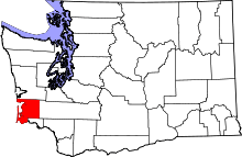 | |
| CDPs | ||
| Other unincorporated communities | ||
| Ghost towns | ||