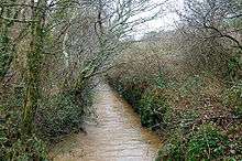
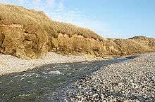
Red River (Koner)
- Not to be confused with the smaller Cornish watercourse which shares the same name which discharges into Mount's Bay west of Marazion on Cornwall's south coast.
| Red River (Dowr Koner) | |
| Country | United Kingdom |
|---|---|
| Region | Cornwall |
| Tributaries | |
| - right | Tehidy Stream |
| Source | |
| - location | Bolenowe |
| - coordinates | 50°11′32″N 5°15′20″W / 50.19222°N 5.25556°W |
| Mouth | |
| - location | Godrevy, St Ives Bay |
| - coordinates | 50°13′42″N 5°22′59″W / 50.22833°N 5.38306°WCoordinates: 50°13′42″N 5°22′59″W / 50.22833°N 5.38306°W |
| Length | 13 km (8 mi) |
 Map of the course of the Red River and the Tehidy Stream | |


The Red River (Cornish: Dowr Koner)[1] is a small river in north-west Cornwall, UK which issues into St Ives Bay at Godrevy on Cornwall's Atlantic coast.[2] The Red River is about 8 miles (13 km) long and gets its name from the mineral deposits associated with tin mining which formerly coloured its water red. The river's gradient is relatively steep; the stream falls 170 metres (560 ft) from source to sea.
Geography
The Red River rises from springs near Bolenowe on the Carnmenellis granite batholith, an upland plateau. The river flows north, passing through a gorge in the granite ridge west of Carn Brea. Beyond the gorge, the river passes Tuckingmill, and Tuckingmill Valley Park, once a centre of mining and associated industries. At the hamlet of Combe, the Tehidy stream joins the Red River which then turns west towards Godrevy.
Tin streaming
The Red River's catchment area includes the major mining areas of Tuckingmill, Pool, and Camborne. Thus:
The Red River catchment has been subjected to mining and mineral working for many centuries, particularly during the eighteenth and nineteenth centuries. It has been extensively tin streamed and its water used for mineral processing, both for use in the mineral separation processes and as a source of power. As a result of past mining activities the river has undergone many modifications and for significant parts of its course the river has been diverted, canalised, and, in places, embanked. Very little, if any, of the river can be considered to be in a truly natural condition.[3]
In The Mining Journal (1872), the author, Mr Watson, asked ″if any stream or gully in Australia, Brazil or California had proved to be so continuously rich and productive as the Red River.″ The river was fed by tributary streams that flowed from the dressing-floors and slime pits of the principal mines, and the ″squatters″ could earn £20,000 per year working on the slimy river-bed. Mr Watson remarked on the inefficiency of the mines in allowing so much tin to be lost. By 1879, Captain James of South Frances mine, estmated £30,000s worth of tin was lost by the mines.[4]
On 25 June 1879 the lease for the tenement of Rosewarne Mill was auctioned at Abraham's Hotel, Camborne. The sale included the "valuable" tin stream works" including a 12-inch cylinder engine, three waterwheels, stamps and all the minerals found in the mill leat and the main river within certain defined boundaries.[5] The Magor Coombe streamworks were bought for £750 by Captain Rabling in 1879[6]
Within Tuckingmill Valley Park is a small island containing the remains of a chimney stack, brick scrubber building and collapsed flue. The buildings (circa 1905) are associated with the production of arsenic which was a valuable resource for Cornish tin and copper mines when production of the metals was declining and the mines were closing. More efficient calcining furnaces were built and the gases fed through convoluted labyrinths where they cooled and condensed on the flue walls. The walls were scraped and the deposits further refined to make 100% pure arsenic. Arsenic was used as a pesticide for the boll weevil (Anthonomus grandis) in the cotton fields of the United States, as well as in the paint and dye industry producing new colours such as canary yellow and emerald green.[7]
High stone-faced banks, are the remains of ten sluices which controlled the flow of water, to enable the recovery of tailings. The slucies were part of the Tolgarrick tin treatment operations which closed in 1986.[7]
Since, South Crofty, the last mine to close in 1998, the Red River has lost its distinctive colour, and natural ecology and biodiversity are being re-established. The river gives its name to the Red River Inn public house (formerly The Pendarves Arms) in nearby Gwithian.
Wildlife and ecology
The Red River is one of the most modified streams in the UK due to centuries of mining which has led to heavy metal contamination and the realignment of the course. The river is gradually re-establishing a more natural look as banks erode and some of the sediment deposited to form bars and small islands.
The river and ponds of the Tuckingmill Valley Park provide valuable habitat within an urban area, for two nationally scarce insects; scarce blue-tailed damselfly (Ischnura pumilio) and small red damselfly (Ceriagrion tenellum). The larvae of the golden-ringed dragonfly (Ceriagrion tenellum) have been found and the adults can be seen through the summer and autumn. Other dragonflies include the common darter (Sympetrum striolatum) and the once rare migrant hawker (Aeshna mixta) which usually fly in August and September.
Both frog (Rana temporaria temporaria) and common toad (Bufo bufo) spawn are found along the edges of the ponds in the early part of the year and the otter (Lutra lutra) has returned following the improvement in water quality. The invasive plants, parrot feather (Myriophyllum aquaticum) is regularly removed by hand to prevent its spread, and the growth of Japanese knotweed (Fallopia japonica) has been restricted by chemical treatment.[7]
See also
- Geology of Cornwall
- The Red River by Paul Williams available from Amazon Books 2016
References
- ↑ Place-names in the Standard Written Form (SWF) : List of place-names agreed by the MAGA Signage Panel. Cornish Language Partnership.
- ↑ Ordnance Survey: Landranger map sheet 203 Land's End ISBN 978-0-319-23148-7
- ↑ "Cornwall County Council Study of the Red River".
- ↑ "The Red River". The Cornishman (74). 11 December 1879. p. 3.
- ↑ "Leasehold Tenements and Tin Stream Works, in Camborne, For Sale". The Cornishman (48). 12 June 1879. p. 1.
- ↑ "The County". The Cornishman (69). 6 November 1879. p. 7.
- 1 2 3 Mitchell, Jon; Moore, Sarah (2009). Tuckingmill Valley Park. Management Plan 2009. Camborne: Kerrier District Council. pp. 21–24.
| Wikimedia Commons has media related to Red River, North Cornwall. |