Redelinghuys
| Redelinghuys | |
|---|---|
|
Redelinghuys | |
 Redelinghuys  Redelinghuys  Redelinghuys
| |
| Coordinates: 32°28′44″S 18°32′17″E / 32.47889°S 18.53806°ECoordinates: 32°28′44″S 18°32′17″E / 32.47889°S 18.53806°E | |
| Country | South Africa |
| Province | Western Cape |
| District | West Coast |
| Municipality | Bergrivier |
| Area[1] | |
| • Total | 2.12 km2 (0.82 sq mi) |
| Elevation | 20 m (70 ft) |
| Population (2011)[1] | |
| • Total | 574 |
| • Density | 270/km2 (700/sq mi) |
| Racial makeup (2011)[1] | |
| • Black African | 23.2% |
| • Coloured | 58.1% |
| • Indian/Asian | 0.5% |
| • White | 17.5% |
| • Other | 0.7% |
| First languages (2011)[1] | |
| • Afrikaans | 95.8% |
| • English | 1.8% |
| • Xhosa | 1.3% |
| • Other | 1.1% |
| Postal code (street) | 8105 |
| PO box | 8105 |
| Area code | 022 |
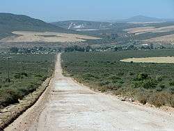
Redelinghuys is a village in the Bergrivier Local Municipality in the Western Cape province of South Africa, located about 160 kilometres (100 mi) north of Cape Town on the Verlorevlei River. The 2001 Census recorded the population as 581 people in 167 households.[2] The village is situated on the R366 regional route between Piketberg and Elands Bay. It is served by a police station, a public library, a satellite health clinic, and two primary schools.
Redelinghuys lies between patches of blue gum trees and is surrounded by a rocky hillside. Redelinghuys is known as the Potato Capital of the Sandveld, and is also the area where the rooibos grows in its natural state and where Rooibos tea is freely available. The town has a predominantly Victorian architecture.
History
Redelinghuys was originally part of the farm Wittedrift. Sir George Napier handed it over on 31 December 1841 to a Mr. Hendrik Koetzee, who died in 1848. A Mr. J.N.L. Redelinghuys bought the farm and gave the church a piece of the farm as a gift. Construction on the first church commenced in 1866 and in 1873 it was used for the first time. Military history was made at Vegkop along the vlei, where Boer lead Brit into a skirmish at the end of the 19th century.[3] In 1921 a new church was built and was first used for the first time in 1927. The old church bell is still in use.
Verlorenvlei
The Verlorenvlei (RAMSAR site) stretches from the upper reaches at Redelinghuys 30 km north and flows into the Atlantic Ocean at Elands Bay. Verlorenvlei is renowned for its prolific birdlife, indigenous fynbos, flora and fauna, potato farms and unspoiled nature. During the flower season, July - September, a kaleidoscopic carpet of sweet-smelling wildflowers springs to life. Among many others, daisies, chinckerenchees, belladonna lilies, arum and Pink Afrikaner (red lily), also called the Sandveld Lily, can be seen.
Verlorenvlei is renowned for its bird life, which number near to 200 species and of which about 75 of those species are waterbirds. The Velorenvlei estuary, is fed by a perennial river that starts in the Cedarberg. It is one of the largest natural wetlands along southern Africa's West Coast. It is connected to the sea via a 2.5-km-long channel. During winter, the lake fills to a maximum depth of 4.5 m and overflows into the sea near Elands Bay.[4]
On 23 September 2014 a part of the southern shore of the vlei was declared as a provincial heritage site for reasons associated with the vernacular fishing village located there. On the same date the Diepkloof Rock Shelter, an internationally important archaeological site associated with the emergence of modern humans and intrinsically connected to the ecology of the vlei, was also declared.[5]
References
- 1 2 3 4 "Main Place Redelinghuys". Census 2011.
- ↑ "Main Place Redelinghuys". Census 2001. Retrieved 30 November 2011.
- ↑ http://www.piketbergtourism.co.za/home/redelinghuys
- ↑ http://www.redelinghuys.net/
- ↑ Provincial Notices 253 & 256/2014, Province of the Western Cape Provincial Gazette Extraordinary, No. 7310, Cape Town: 23 September 2014
Municipalities and communities of West Coast District Municipality, Western Cape | ||
|---|---|---|
District seat: Moorreesburg | ||
| Matzikama | .svg.png) | |
| Cederberg | ||
| Bergrivier | ||
| Saldanha Bay | ||
| Swartland | ||