List of regions of Quebec
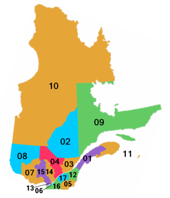
The province of Quebec, Canada, was officially divided into 17 administrative regions. Traditionally (and unofficially), it is divided into around twenty regions. As of the 2011 Canadian Census, the population of Quebec was 7,903,001, the land area was 1,356,547.02 km2 and the population density was 5.8 inhabitants per square kilometre.
Administrative
Administrative regions were used to organize the delivery of provincial government services. They were also the basis of organization for regional conferences of elected officers (French: conférences régionales des élus, CRÉ), with the exception of the Montérégie and Nord-du-Québec regions, which each use to have three CRÉs or equivalent bodies. (In the Nord-du-Québec region, the Kativik Regional Government and Cree Regional Authority, in addition to their other functions, play the role of a CRÉ).
Administrative Regions
The subregions of Montérégie and Nord-du-Québec have their own regional conference of elected officers (CRÉ). Municipalities with 20,000-plus populations in the 2011 Census are listed, with those 50,000 or over bolded. In addition, the seat[1] of the relevant CRÉ is indicated, as well as other major cities and towns. If the population of a CRÉ is less than 20,000, it is shown in italics.
| Code | Region | Population Canada 2011 Census[2] |
Land area | Density (pop. per km2) |
Seat of RCE (CRÉ) | Other major cities |
|---|---|---|---|---|---|---|
| 01 | Bas-Saint-Laurent | 199,977 | 22,234.10 km2 (8,584.63 sq mi) | 9.0 | Rimouski | Riviere-du-Loup |
| 02 | Saguenay–Lac-Saint-Jean | 274,880 | 98,710.11 km2 (38,112.19 sq mi) | 2.8 | Saguenay | Alma |
| 03 | Capitale-Nationale | 700,616 | 18,796.86 km2 (7,257.51 sq mi) | 37.3 | Quebec City | |
| 04 | Mauricie | 263,603 | 35,864.93 km2 (13,847.53 sq mi) | 7.3 | Trois-Rivières | Shawinigan |
| 05 | Estrie | 310,733 | 10,214.34 km2 (3,943.78 sq mi) | 30.4 | Sherbrooke | Magog |
| 06 | Montréal[3] | 1,886,481 | 499.19 km2 (192.74 sq mi) | 3,779.1 | Montreal | Westmount, Côte Saint-Luc, Pointe-Claire, Kirkland, Dollard-des-Ormeaux |
| 07 | Outaouais | 369,171 | 30,802.91 km2 (11,893.07 sq mi) | 12.0 | Gatineau | |
| 08 | Abitibi-Témiscamingue | 145,690 | 57,738.95 km2 (22,293.13 sq mi) | 2.5 | Rouyn-Noranda | Val-d'Or, Amos |
| 09 | Côte-Nord | 94,766 | 247,633.94 km2 (95,612.00 sq mi) | 0.4 | Baie-Comeau | Sept-Îles |
| 10 | Nord-du-Québec | 42,579 | 747,161.22 km2 (288,480.56 sq mi) | 0.1 | ||
| CRÉ de la Baie-James[4] | Matagami | |||||
| Cree Regional Authority | Nemaska | |||||
| Kativik Regional Government | Kuujjuaq | |||||
| 11 | Gaspésie–Îles-de-la-Madeleine | 94,079 | 20,308.67 km2 (7,841.22 sq mi) | 4.6 | Gaspé | |
| 12 | Chaudière-Appalaches | 410,829 | 15,080.30 km2 (5,822.54 sq mi) | 27.2 | Montmagny | Lévis, Saint-Georges, Thetford Mines |
| 13 | Laval[5] | 401,553 | 247.09 km2 (95.40 sq mi) | 1,625.1 | Laval | |
| 14 | Lanaudière | 471,748 | 12,422.23 km2 (4,796.25 sq mi) | 38.0 | Joliette | Repentigny, Terrebonne, Mascouche |
| 15 | Laurentides | 559,700 | 20,771.13 km2 (8,019.78 sq mi) | 26.9 | Saint-Jérôme | Saint-Eustache, Boisbriand, Sainte-Thérèse, Blainville, Mirabel |
| 16 | Montérégie | 1,442,433 | 11,131.32 km2 (4,297.83 sq mi) | 129.6 | ||
| CRÉ de Longueuil[3] | Longueuil | Brossard, Saint-Lambert, Boucherville, Saint-Bruno-de-Montarville | ||||
| CRÉ Montérégie Est[6] | McMasterville | Granby, Sorel-Tracy, Saint-Hyacinthe, Saint-Jean-sur-Richelieu, Chambly, McMasterville*, Sainte-Julie, Varennes | ||||
| CRÉ Vallée-du-Haut-Saint-Laurent[7] | Salaberry-de-Valleyfield | La Prairie, Saint-Constant, Châteauguay, Vaudreuil-Dorion | ||||
| 17 | Centre-du-Québec | 234,163 | 6,929.73 km2 (2,675.58 sq mi) | 33.8 | Drummondville | Victoriaville |
| Total | 7,903,001 | 1,356,547.02 km2 (523,765.73 sq mi) | 5.8 | |||
- Mauricie–Bois-Francs was split in 1997 to create Mauricie and Centre-du-Québec administrative regions (note, the notion of Mauricie as a traditional region long predates this)
- In January 2000, Québec administrative region was renamed Capitale-Nationale.
Historical and traditional names
Quebec has a number of regions that go by historical and traditional names. Often, they have similar but distinct French and English names.
- Abitibi
- Lower Saint Lawrence (Bas-Saint-Laurent)
- Beauce (within Chaudière-Appalaches)
- Bois-Francs (within Centre-du-Québec)
- Charlevoix (eastern part of the Capitale-Nationale administrative region)
- Chateauguay Valley
- North Shore/Lower North Shore
- Eastern Townships (Cantons-de-l'Est)
- Gaspésie
- Lac-Saint-Jean
- Magdalen Islands (Îles de la Madeleine)
- James Bay (Jamésie)
- Lanaudière
- Laurentians (Laurentides)
- Mauricie
- Montérégie
- Montreal region/Greater Montreal/Island of Montreal
- Nord-du-Québec (or Grand-Nord)
- Nunavik
- Ottawa Valley
- Outaouais
- Pontiac
- Quebec City region (corresponds to Capitale-Nationale)
- Rupert's Land
- Saguenay–Lac-Saint-Jean
- South Shore (Montreal) (Rive-Sud)
- Timiskaming (Témiscamingue)
- Ungava District
See also
| Wikimedia Commons has media related to Regions of Quebec. |
- Administrative divisions of Quebec
- Regional conference of elected officers (CRÉ)
- Administrative divisions of Canada
- Quebec regional cultures
- List of people from the Gaspé Peninsula
- List of people from Mauricie
- List of people from Saguenay–Lac-Saint-Jean
- Regional municipality, an equivalent type of municipal government in Ontario
References
- ↑ Coordonnées — Conférences régionales des élus, Ministère des Affaires municipales et régionales
- ↑ "Population and dwelling counts, for Canada, provinces and territories, and economic regions, 2011 and 2006 censuses". Canada 2011 Census. Statistics Canada. 2012-04-11. Retrieved 10 July 2012.
- 1 2 Coextensive with the urban agglomeration of the same name
- ↑ Territory consists of the municipalities of Matagami, Lebel-sur-Quévillon, Chibougamau, Chapais and Baie-James. Portrait de la Jamésie, Conférence régionale des élus de la Baie-James
- ↑ Coextensive with the equivalent territory and municipality of the same name
- ↑ Territory consists of the regional county municipalities of La Haute-Yamaska, Acton, Pierre-De Saurel, Les Maskoutains, Rouville, Le Haut-Richelieu, La Vallée-du-Richelieu and Marguerite-D'Youville.
- ↑ Territory consists of the regional county municipalities of Roussillon, Les Jardins-de-Napierville Le Haut-Saint-Laurent, Beauharnois-Salaberry and Vaudreuil-Soulanges
| Subdivisions | |
|---|---|
| Communities | |
| Major cities | |
| Regions | |
| Provinces |
|
|---|---|
| Territories |
|
| |