Terrain
.jpg)
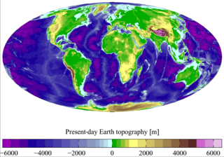
Terrain or relief (also topographical relief) is the vertical and horizontal dimension of the land surface. When relief is described underwater, the term bathymetry is used. The Latin Word "Terra (The root word of terrain)," is "Earth."
Terrain is used as a general term in physical geography, referring to the lay of the land. This is usually expressed in terms of the elevation, slope, and orientation of terrain features. Terrain affects surface water flow and distribution. Over a large area, it can affect weather and climate patterns.
Importance
The understanding of terrain is critical for many reasons:
- The terrain of a region largely determines its suitability for human settlement: flatter, alluvial plains tend to have better farming soils than steeper, rockier uplands.
- In terms of environmental quality, agriculture, and hydrology, understanding the terrain of an area enables the understanding of watershed boundaries, drainage characteristics, water movement, and impacts on water quality. Complex arrays of relief data are used as input parameters for hydrology transport models (such as the SWMM or DSSAM Models) to allow prediction of river water quality.
- Understanding terrain also supports soil conservation, especially in agriculture. Contour ploughing is an established practice enabling sustainable agriculture on sloping land; it is the practice of ploughing along lines of equal elevation instead of up and down a slope.
- Terrain is militarily critical because it determines the ability of armed forces to take and hold areas, and move troops and material into and through areas. An understanding of terrain is basic to both defensive and offensive strategy.
- Terrain is important in determining weather patterns. Two areas geographically close to each other may differ radically in precipitation levels or timing because of elevation differences or a "rain shadow" effect.
- Precise knowledge of terrain is vital in aviation, especially for low-flying routes and maneuvers (see terrain collision avoidance) and airport altitudes. Terrain will also affect range and performance of radars and terrestrial radio navigation systems. Furthermore, a hilly or mountainous terrain can strongly impact the implementation of a new aerodrome and the orientation of its runways.
Relief
Relief (or local relief) refers specifically to the quantitative measurement of vertical elevation change in a landscape. It is the difference between maximum and minimum elevations within a given area, usually of limited extent.[1] The relief of a landscape can change with the size of the area over which it is measured, making the definition of the scale over which it is measured very important. Because it is related to the slope of surfaces within the area of interest and to the gradient of any streams present, the relief of a landscape is a useful metric in the study of the Earth's surface. Relief energy, which may be defined inter alia as "the maximum height range in a regular grid",[2] is essentially an indication of the ruggedness or relative height of the terrain.
Geomorphology
Geomorphology is in large part the study of the formation of terrain or topography. Terrain is formed by intersecting processes:
- Geological processes: Migration of tectonic plates, faulting and folding, volcanic eruptions, rivers.
- Erosional processes: water and wind erosion, landslides.
- Extraterrestrial: meteorite impacts.
Tectonic processes such as orogenies cause land to be elevated, and erosional or weathering processes cause land to be worn away to lower elevations.
Land surface parameters are quantitative measures of various morphometric properties of a surface. The most common examples are used to derive slope or aspect of a terrain or curvatures at each location. These measures can also be used to derive hydrological parameters that reflect flow/erosion processes. Climatic parameters are based on the modelling of solar radiation or air flow.
Land surface objects, or landforms, are definite physical objects (lines, points, areas) that differ from the surrounding objects. The most typical examples airlines of watersheds, stream patterns, ridges, break-lines, pools or borders of specific landforms.
See also
- Applications of global navigation satellite systems (GNSS)
- Cartographic relief depiction (2D relief map)
- Digital terrain model
- Geographic information system (GIS)
- Geomorphometry
- Physical terrain model
- Relief ratio
- Subterranea
- Terrain awareness and warning system
- Terrane
- Topography
References
- ↑ Summerfield, M.A., 1991, Global Geomorphology, Pearson, 537 p. ISBN 9780582301566
- ↑ African Landscapes: Interdisciplinary Approaches, edited by Michael Bollig, Olaf Bubenzer. Cologne: Springer, 2009, p. 48.
Additional reading
- Boots on the ground. On military terrain from the perspective of the combat soldier. By Professor Derek Gregory
External links
![]() The dictionary definition of terrain at Wiktionary
The dictionary definition of terrain at Wiktionary