Remedios, Cuba
| Remedios (San Juan de los Remedios) | |
|---|---|
| Municipality | |
|
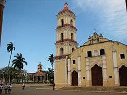
Iglesia Mayor in Remedios | |
.png) Remedios municipality (red) within Villa Clara Province (yellow) and Cuba | |
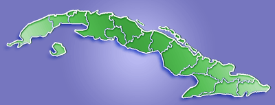 Location of Remedios in Cuba | |
| Coordinates: 22°29′32″N 79°32′45″W / 22.49222°N 79.54583°WCoordinates: 22°29′32″N 79°32′45″W / 22.49222°N 79.54583°W | |
| Country |
|
| Province | Villa Clara |
| Established | 1513 |
| Area[1] | |
| • Total | 560 km2 (220 sq mi) |
| Elevation | 25 m (82 ft) |
| Population (2004)[2] | |
| • Total | 46,482 |
| • Density | 83.0/km2 (215/sq mi) |
| Time zone | EST (UTC-5) |
| Area code(s) | +53-42-39 |
Remedios (Spanish pronunciation: [reˈmeðjos]), also known as San Juan de los Remedios, is a city and municipality located 3 miles (4.8 km) from the northern coast of Cuba, in the center of the island. It is the oldest Spanish settlement in the former Las Villas province. It is now part of the province of Villa Clara. It was declared a City by Isabella II of Spain, when the Island was still a colony. Remedios is the Cradle of the Parrandas, possibly the Caribbean's largest and oldest traditional festivity. Its patrons are San Juan Bautista and the Virgin of the Buenviaje.
Geography
Remedios is located about 4 hours away by bus from Havana, around 50 minutes from Santa Clara and there is less than an hour from there to beach resorts in the Santa María - Las Brujas cays both situated north of the province. The municipality limits to the north with Caibarien, to the south with Camajuani and Placetas, and to the east with Yaguajay ( Sancti Spiritus)
History
It is recognized as the eighth oldest city in Cuba, but its real date of foundation has been obscured over time, and it may be the second Spanish settlement on the island. Historians place the foundation date sometime between 1513 and 1524 by Spanish nobleman Vasco Porcallo de Figueroa, originally founded by him on the 13th of April 1514. Documents reflect that this settlement was only preceded by Baracoa (1511) and (Bayamo)(1512). Considering these facts some believe it was actually founded before Trinidad (1514). Rumor has it that Vasco, in order to avoid tax payments to the crown, maintained the village hidden from the knowledge of the King of Spain as long as he could, but the village grew quickly, and at some point it had to be recognized. Through his wife, the daughter of the Cacique of Sabaneque, Vasco received a huge land grant as a personal fief from Gobernor Diego Velazquez as stipulated by Spanish law, therefore it had no municipal entity to govern the town. Upon Vasco's death in Puerto Principe in 1550 the town obtained its charter.
It was originally called Santa Cruz de la Sabana, Santa Cruz de Vasco Porcallo, Santa Cruz de la Sabana del Cayo and lastly by 1578 San Juan de los Remedios de la Sabana del Cayo. In the 16th, 17th and 18th centuries there was a steady progress defined by land grants, which allowed for a stable population settlement. The economic growth relied on agriculture and cattle raising, eventually becoming one of the major beef suppliers to the Florida colonies.
By 1678 the demarcation between Remedios and Sancti Spiritus was already established. Along with cattle raising the sugar industry was developed and by the end of the 17th and beginning of the 18th century the cultivation of tobacco, coffee and cacao was begun. In 1682, a major dispute arose among the settlers, led by Father Gonzalez de la Cruz, who claimed that satanic forces had taken hold of the place. This led the Spanish Crown to send a Royal Decree dated 29 January 1684 transferring the settlement to another place. Only 18 families left the town and went on to establish on the 15th of July 1689 the village of Santa Clara, today an important city in the center of Cuba and the capital of the province of Villa Clara.
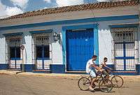
Its long history is particularly evident in the city center (declared National Historic Monument in 1980[3]), where 17th century Spanish architecture can still be found intact.
Demographics

In 2004, the municipality of Remedios had a population of 46,482.[2] With a total area of 560 km2 (220 sq mi),[1] it has a population density of 83.0/km2 (215/sq mi).
Attractions

The main attraction in the Plaza Isabel II is the "Iglesia Mayor" of San Juan Bautista containing 13 beautifully decorated gold altars. The city was under constant siege by pirates and corsaires, most famous attacker was François l'Olonnais, therefore the gold was hidden under white paint. In a renovation that took place between 1944 and 1954 thanks to the generous Cuban millionaire philanthropist Eutimio Falla Bonet, the real gold under coats of paint were re-discovered. The story goes that Falla Bonet traced his family tree back to Remedios, and found that one of his ancestors had been a founding member of the city and had been born in Remedios. On the north side of the square sits another church, the less fortunate Iglesia del Buen Viaje. Remedios is the only town in Cuba with two churches on its main square, but the Iglesia del Buen Viaje is abandoned, leaking and closed until repairs are authorized by the Communist government. The Central Plaza or "Plaza Mayor" was restored in 1970 and is surrounded by colonial buildings, beautiful monuments, trees, palms and a gazebo like many towns in Cuba, following a Spanish urban standard.
Remedios is distinguished by many Cubans for its Christmas festival, "Las Parrandas de Remedios", one of the most popular events of the region that takes place between the 16th to the 26th of December every year. Considered the oldest festivities in Cuba, the "parrandas" were initially promoted by Father Francisco Vigil de Quiñones, who used to officiate at the Iglesia Mayor of San Juan Bautista de los Remedios. The priest, who was concerned about the absence of parishioners at the "Misa de Gallo" (midnight mass), had the idea of encouraging children to take to the streets and wake up the citizens using whistles, horns and tin cans, so that they had no other choice than get up and attend mass. That singular and noisy initiative got deeply rooted among the population, resulting in the most attractive festivity in the country. In 1871, the "parrandas" adopted a structure that has survived the passage of time. According to tradition, when the bells of the Iglesia Parroquial Mayor (Major Parochial Church) toll at 9 o'clock on the night of December 24, two neighborhoods make public their creativeness and efforts made during the entire year to participate in the competition. During the "parrandas", a "fierce" competition takes place between the neighborhoods of San Salvador, represented by the colors red and blue, and a rooster as a symbol, and El Carmen, represented by the color brown and a globe. The memory of those celebrations is compiled at the Museum of Parrandas, which opened in a 19th-century building in 1980 in Remedios, where photos, documents and hand-made objects linked to the festivities are preserved.
Personalities
- Alejandro García Caturla (1906-1940), composer
- José Luis Nápoles, sports journalist and anchor
- Jorge Luis Toca (b. 1975), former professional baseball player
- Dayán Viciedo Pérez (b. 1989), professional baseball player
Sister cities
 Ann Arbor, United States
 La Orotava, Spain
- Normal, Illinois[4]
See also
References
- 1 2 Statoids (July 2003). "Municipios of Cuba". Retrieved 2007-10-09.
- 1 2 Atenas.cu (2004). "2004 Population trends, by Province and Municipality" (in Spanish). Archived from the original on 2007-09-27. Retrieved 2007-10-09.
- ↑ National Council for Cultural Heritage. "National Monuments in Cuba" (in Spanish). Retrieved 2007-10-09.
- ↑ Sister Cities International Directory: Remedios, Cuba
External links
| Wikimedia Commons has media related to Remedios. |