Riegelwood, North Carolina
| Riegelwood, North Carolina | |
|---|---|
| Census-designated place | |
|
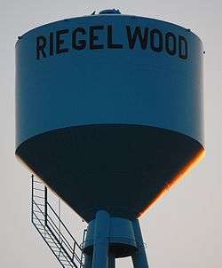
Riegelwood Watertower | |
 Riegelwood  Riegelwood Location within the state of North Carolina | |
| Coordinates: 34°20′23″N 78°13′30″W / 34.33972°N 78.22500°WCoordinates: 34°20′23″N 78°13′30″W / 34.33972°N 78.22500°W | |
| Country | United States |
| State | North Carolina |
| County | Columbus |
| Area | |
| • Total | 3.4 sq mi (8.8 km2) |
| • Land | 3.1 sq mi (8.1 km2) |
| • Water | 0.3 sq mi (0.7 km2) |
| Elevation | 41.7 ft (12.7 m) |
| Population (2010) | |
| • Total | 579 |
| • Density | 185/sq mi (71.6/km2) |
| Time zone | Eastern (EST) (UTC-5) |
| • Summer (DST) | EDT (UTC-4) |
| ZIP code | 28456 |
| Area code(s) | 910 |
| FIPS code | 37-56600[1] |
| GNIS feature ID | 1022290[2] |
Riegelwood is an unincorporated community and census-designated place (CDP) in Columbus County, North Carolina, United States. As of the 2010 census it had a population of 579.[3] It is a location of paper mills for the lumber industry.
History
The Black Rock Plantation House was listed on the National Register of Historic Places in 2014.[4]
Geography
Riegelwood is located near the eastern tip of Columbus County, south of Mitchell Landing on the Cape Fear River, site of an International Paper plant. North Carolina Highway 87 passes through Riegelwood, leading southeast 2 miles (3 km) to U.S. Routes 74 and 76 in Delco and northwest 30 miles (48 km) to Elizabethtown. Wilmington is 19 miles (31 km) to the southeast via US 74/76.
According to the U.S. Census Bureau, the Riegelwood CDP has a total area of 3.4 square miles (8.8 km2), of which 3.1 square miles (8.1 km2) is land and 0.27 square miles (0.7 km2), or 8.28%, is water.[3]
Severe weather event in 2006
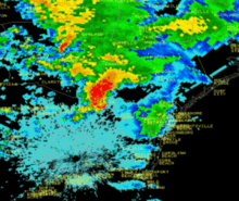
On November 16, 2006, at 6:29 am EST, a tornado warning had been issued for eastern Columbus County, and prior to that a severe thunderstorm warning was issued for the same area at 6:21 am. At 6:37, an F3 tornado struck a mobile home park and killed eight people, including two children, Danny Jacobs, 6, and Miguel Martinez, 13. Twenty people were injured. The tornado was a part of a 3-day long tornado outbreak in the south where four other deaths were reported. Riegelwood was one of the hardest hit areas.
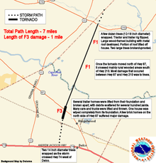
On Friday, November 17, 2006 a NOAA National Weather Service storm survey team assessed the tornado damage in Riegelwood and rated it at F3 on the Fujita scale for nearly a mile in Riegelwood, with winds approaching 200 miles per hour (320 km/h). The maximum width of the tornado was 300 yards where the F3 damage occurred. The rest of the 7-mile (11 km) damage path was narrow, less than a 100 yards wide, and rated at F1 with winds less than 100 mph extending north across Columbus County into western Pender County.
The Columbus County sheriff reported thirty homes destroyed in the F3 damage area, and another three structures were damaged in Pender County just west of Currie.
References
- ↑ "American FactFinder". United States Census Bureau. Archived from the original on September 11, 2013. Retrieved 2008-01-31.
- ↑ "US Board on Geographic Names". United States Geological Survey. 2007-10-25. Retrieved 2008-01-31.
- 1 2 "Geographic Identifiers: 2010 Demographic Profile Data (G001): Riegelwood CDP, North Carolina". U.S. Census Bureau, American Factfinder. Retrieved January 2, 2015.
- ↑ "National Register of Historic Places Listings". Weekly List of Actions Taken on Properties: 12/15/14 through 12/19/14. National Park Service. 2014-12-24.
Municipalities and communities of Columbus County, North Carolina, United States | ||
|---|---|---|
| City | 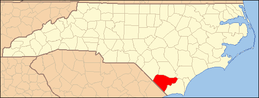 | |
| Towns | ||
| CDPs | ||
| Unincorporated communities | ||