Clarendon, North Carolina
| Clarendon, North Carolina | |
|---|---|
| Unincorporated community | |
 Clarendon, North Carolina  Clarendon, North Carolina | |
| Coordinates: 34°12′37″N 78°50′43″W / 34.21028°N 78.84528°WCoordinates: 34°12′37″N 78°50′43″W / 34.21028°N 78.84528°W | |
| Country | United States |
| State | North Carolina |
| County | Columbus |
| Elevation | 105 ft (32 m) |
| Time zone | Eastern (EST) (UTC-5) |
| • Summer (DST) | EDT (UTC-4) |
| ZIP code | 28432 |
| Area code(s) | 910 |
| GNIS feature ID | 983208[1] |
Clarendon is an unincorporated community in Columbus County, North Carolina, United States. The community is located along a railroad and North Carolina Highway 410 4.6 miles (7.4 km) north-northeast of Tabor City. Clarendon has a post office with ZIP code 28432.[2][3]
References
- ↑ "Clarendon". Geographic Names Information System. United States Geological Survey.
- ↑ United States Postal Service (2015). "USPS - Look Up a ZIP Code". Retrieved February 13, 2015.
- ↑ "Postmaster Finder - Post Offices by ZIP Code". United States Postal Service. Retrieved February 13, 2015.
Municipalities and communities of Columbus County, North Carolina, United States | ||
|---|---|---|
| City | 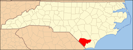 | |
| Towns | ||
| CDPs | ||
| Unincorporated communities | ||
This article is issued from Wikipedia - version of the 7/27/2016. The text is available under the Creative Commons Attribution/Share Alike but additional terms may apply for the media files.