Rimrock, Washington
| Rimrock, Washington | |
|---|---|
| Unincorporated community | |
 Rimrock, Washington Location of Rimrock, Washington | |
| Coordinates: 46°39′51″N 121°07′30″W / 46.6642842°N 121.1250795°WCoordinates: 46°39′51″N 121°07′30″W / 46.6642842°N 121.1250795°W[1] | |
| Country | United States |
| State | Washington |
| County | Yakima |
| Elevation[2] | 2,730 ft (832 m) |
| Time zone | Pacific (PST) (UTC-8) |
| • Summer (DST) | PDT (UTC-7) |
| ZIP code | 98937 |
| Area code(s) | 509 |
| GNIS feature ID | 1525055[2] |
Rimrock is an unincorporated community in Yakima County, Washington, United States, located approximately 22 miles west of Yakima on the Tieton River, adjacent to Rimrock Lake.
The community was named for nearby Rimrock Lake, a seven mile long dammed reservoir on the Tieton River.[3]
Rimrock is served by Tieton State Airport, a grass airstrip located 2 miles south of Rimrock.
References
- ↑ "Rimrock". Geographic Names Information System. United States Geological Survey. Retrieved 2012-10-27.
- 1 2 "US Board on Geographic Names". United States Geological Survey. 2007-10-25. Retrieved 2008-01-31.
- ↑ "Washington Place Names database". Tacoma Public Library. Retrieved October 27, 2012.
Municipalities and communities of Yakima County, Washington, United States | ||
|---|---|---|
| Cities | 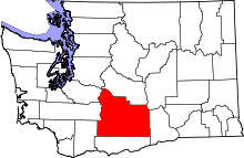 | |
| Towns | ||
| CDPs | ||
| Other unincorporated communities | ||
| Indian reservation | ||
| Footnotes | ‡This populated place also has portions in an adjacent county or counties | |
This article is issued from Wikipedia - version of the 9/5/2016. The text is available under the Creative Commons Attribution/Share Alike but additional terms may apply for the media files.