Harrah, Washington
| Harrah | |
|---|---|
| Town | |
| Harrah, Washington | |
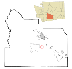 Location of Harrah, Washington | |
| Coordinates: 46°24′15″N 120°32′35″W / 46.40417°N 120.54306°WCoordinates: 46°24′15″N 120°32′35″W / 46.40417°N 120.54306°W | |
| Country | United States |
| State | Washington |
| County | Yakima |
| Area[1] | |
| • Total | 0.22 sq mi (0.57 km2) |
| • Land | 0.22 sq mi (0.57 km2) |
| • Water | 0 sq mi (0 km2) |
| Elevation | 833 ft (254 m) |
| Population (2010)[2] | |
| • Total | 625 |
| • Estimate (2015)[3] | 628 |
| • Density | 2,840.9/sq mi (1,096.9/km2) |
| Time zone | Pacific (PST) (UTC-8) |
| • Summer (DST) | PDT (UTC-7) |
| ZIP code | 98933 |
| Area code | 509 |
| FIPS code | 53-29710[4] |
| GNIS feature ID | 1512275[5] |
Harrah is a town in Yakima County, Washington, United States. The population was 625 at the 2010 census. It is on the Yakama Indian Reservation.
History
Named after Julius Harrah, Harrah was officially incorporated on January 23, 1946. In 1950 it had a population of 297.[6]
Geography
Harrah is located at 46°24′15″N 120°32′35″W / 46.40417°N 120.54306°W (46.404182, -120.542982).[7]
According to the United States Census Bureau, the town has a total area of 0.22 square miles (0.57 km2), all of it land.[1]
Demographics
| Historical population | |||
|---|---|---|---|
| Census | Pop. | %± | |
| 1950 | 297 | — | |
| 1960 | 284 | −4.4% | |
| 1970 | 305 | 7.4% | |
| 1980 | 343 | 12.5% | |
| 1990 | 341 | −0.6% | |
| 2000 | 542 | 58.9% | |
| 2010 | 625 | 15.3% | |
| Est. 2015 | 628 | [8] | 0.5% |
| U.S. Decennial Census[9] 2015 Estimate[3] | |||
2010 census
As of the census[2] of 2010, there were 625 people, 177 households, and 142 families residing in the town. The population density was 2,840.9 inhabitants per square mile (1,096.9/km2). There were 183 housing units at an average density of 831.8 per square mile (321.2/km2). The racial makeup of the town was 24.6% White, 0.5% African American, 21.3% Native American, 0.2% Asian, 48.3% from other races, and 5.1% from two or more races. Hispanic or Latino of any race were 55.4% of the population.
There were 177 households of which 49.7% had children under the age of 18 living with them, 57.1% were married couples living together, 12.4% had a female householder with no husband present, 10.7% had a male householder with no wife present, and 19.8% were non-families. 16.4% of all households were made up of individuals and 6.3% had someone living alone who was 65 years of age or older. The average household size was 3.53 and the average family size was 3.89.
The median age in the town was 29.2 years. 32.5% of residents were under the age of 18; 11.7% were between the ages of 18 and 24; 27.1% were from 25 to 44; 19.8% were from 45 to 64; and 8.8% were 65 years of age or older. The gender makeup of the town was 48.3% male and 51.7% female.
2000 census
As of the census[4] of 2000, there were 542 people, 167 households, and 131 families residing in the town. The population density was 1,887.0 people per square mile (721.6/km²). There were 179 housing units at an average density of 623.2 per square mile (238.3/km²). The racial makeup of the town was 40.59% White, 0.37% African American, 19.19% Native American, 0.37% Asian, 33.03% from other races, and 6.46% from two or more races. Hispanic or Latino of any race were 44.10% of the population.
There were 167 households out of which 48.5% had children under the age of 18 living with them, 61.7% were married couples living together, 12.6% had a female householder with no husband present, and 21.0% were non-families. 18.6% of all households were made up of individuals and 7.8% had someone living alone who was 65 years of age or older. The average household size was 3.25 and the average family size was 3.72.
In the town the age distribution of the population shows 38.0% under the age of 18, 6.6% from 18 to 24, 26.4% from 25 to 44, 20.1% from 45 to 64, and 8.9% who were 65 years of age or older. The median age was 29 years. For every 100 females there were 106.9 males. For every 100 females age 18 and over, there were 100.0 males.
The median income for a household in the town was $36,875, and the median income for a family was $41,250. Males had a median income of $31,250 versus $25,000 for females. The per capita income for the town was $12,721. About 14.5% of families and 19.8% of the population were below the poverty line, including 29.0% of those under age 18 and 16.4% of those age 65 or over.
School District
Harrah Elementary is part of School Dist. No. 209, also known as the Mt. Adams School District.
References
- 1 2 "US Gazetteer files 2010". United States Census Bureau. Retrieved 2012-12-19.
- 1 2 "American FactFinder". United States Census Bureau. Retrieved 2012-12-19.
- 1 2 "Population Estimates". United States Census Bureau. Retrieved June 29, 2016.
- 1 2 "American FactFinder". United States Census Bureau. Retrieved 2008-01-31.
- ↑ "US Board on Geographic Names". United States Geological Survey. 2007-10-25. Retrieved 2008-01-31.
- ↑ Columbia-Lippincott Gazeteer, p. 760
- ↑ "US Gazetteer files: 2010, 2000, and 1990". United States Census Bureau. 2011-02-12. Retrieved 2011-04-23.
- ↑ "Annual Estimates of the Resident Population for Incorporated Places: April 1, 2010 to July 1, 2015". Retrieved July 2, 2016.
- ↑ United States Census Bureau. "Census of Population and Housing". Retrieved August 31, 2014.
Municipalities and communities of Yakima County, Washington, United States | ||
|---|---|---|
| Cities | 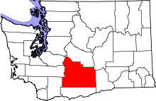 | |
| Towns | ||
| CDPs | ||
| Other unincorporated communities | ||
| Indian reservation | ||
| Footnotes | ‡This populated place also has portions in an adjacent county or counties | |