Tamaulipas
| Tamaulipas Estado Libre y Soberano de Tamaulipas | |||
|---|---|---|---|
| State | |||
| Free and Sovereign State of Tamaulipas | |||
| |||
|
Motto: Aunque rústicos, estas armas cuya luz ha venido de esta cruz y son de linaje y casa de Escandón (Even Rustic, These Arms Whose Light Has Come From This Cross; And Are Lineage And House Of Escandon) | |||
| Anthem: Himno de Tamaulipas | |||
.svg.png) State of Tamaulipas within Mexico | |||
| Coordinates: 24°17′N 98°34′W / 24.283°N 98.567°WCoordinates: 24°17′N 98°34′W / 24.283°N 98.567°W | |||
| Capital | Ciudad Victoria | ||
| Largest city | Reynosa | ||
| Largest metro | Reynosa | ||
| Admission | February 7, 1824[1] | ||
| Order | 14th | ||
| Government | |||
| • Governor |
Francisco García Cabeza de Vaca ( | ||
| • Senators[2] |
Francisco García Cabeza de Vaca Maki Esther Ortiz Manuel Cavazos Lerma | ||
| • Deputies[3] | |||
| Area[4] | |||
| • Total | 80,249 km2 (30,984 sq mi) | ||
| Ranked 6th | |||
| Highest elevation[5] | 3,280 m (10,760 ft) | ||
| Population (2015)[6] | |||
| • Total | 3,441,698 | ||
| • Rank | 13th | ||
| • Density | 43/km2 (110/sq mi) | ||
| • Density rank | 21st | ||
| Demonym(s) | Tamaulipeco (a) | ||
| Time zone | CST (UTC−6) | ||
| • Summer (DST) | CDT (UTC−5) | ||
| Postal code | 87–89 | ||
| Area code | |||
| ISO 3166 code | MX-TAM | ||
| HDI |
| ||
| GDP | US$ 20,789,236.56 th[a] | ||
| Website | Official Web Site | ||
| ^ a. The state's GDP was $266,102,228 thousand of pesos in 2008, amount corresponding to $20,789,236.56 thousand of dollars, being a dollar worth 12.80 pesos (value of June 3, 2010).[7] | |||
Tamaulipas (Spanish pronunciation: [tamauˈlipas]), officially the Free and Sovereign State of Tamaulipas (Spanish: Estado Libre y Soberano de Tamaulipas), is one of the 31 states which, with Mexico City, comprise the 32 Federal Entities of Mexico. It is divided into 43 municipalities and its capital city is Ciudad Victoria. The capital city was named after Guadalupe Victoria, the first President of Mexico.
It is located in Northeastern Mexico. It is bordered by the states of Veracruz to the southeast, San Luis Potosí to the southwest and Nuevo León to the west. To the north, it has a 370 km (230 mi) stretch of the U.S.–Mexico border along the state of Texas.[8]
The name Tamaulipas is derived from Tamaholipa, a Huastec term in which the tam- prefix signifies "place (where)". There is no scholarly agreement on the meaning of holipa, but "high hills" is a common interpretation.[9] Another explanation of the state name is that it is derived from Ta ma ho'lipam ("place where the Lipan prey").
In addition to the capital city, Ciudad Victoria, the state's largest cities include Reynosa, Matamoros, Nuevo Laredo, and Tampico.
History
The area known as Tamaulipas has been inhabited for at least 8,000 years. Several different cultures (north coastal, south coastal, lowlands, and mountains) have come and gone during that period.
Tamaulipas was originally populated by the Olmec people and later by Chichimec and Huastec tribes. Between 1445 and 1466, Mexica (or Aztec) armies commanded by Moctezuma I Ilhuicamina conquered much of the territory and transformed it into a tributary region for the Mexica empire. However, the Aztecs never fully conquered certain mostly nomadic indigenous groups in the area.
Although Hernán Cortés conquered the Aztecs rather quickly, it took a gradual process for Spain to subjugate the inhabitants of Tamaulipas in the 16th and 17th centuries. The first permanent Spanish settlement in the area was Tampico in 1554. Further settlement was done by Franciscan missionaries, widespread cattle and sheep ranching by the Spanish bolstered the area’s economy while forcing native populations from their original lands. Repeated indigenous rebellions kept the area unstable and weakened colonial interest in the region. What is now Tamaulipas was first incorporated as a separate province of New Spain in 1746 with the name Nuevo Santander. The local government capital during this time moved from Santander to San Carlos, and finally to Aguayo. The territory of this time spanned from the San Antonio river to the north east to the Gulf of Mexico, then south to the Panuco River near Tampico and west to the Sierra Madre Mountains. The area became a haven for rebellious Indians who fled there after increased Spanish settlements in Nuevo León and Coahuila.
In the middle 17th century various Apache bands from the southern Plains, after acquiring horses from Europeans in New Mexico, moved southeastward into the Edwards Plateau, displacing the native hunting and gathering groups. One of these groups was known as Lipan (see Hodge 1907 Vol. I:769 for a confusing list of synonyms). After 1750, when most Apache groups of the central Texas highlands were displaced by Comanche and moved into the coastal plain of southern Texas, the Europeans of the San Antonio area began referring to all Apache groups in southern Texas as Lipan or Lipan Apache (Campbell and Campbell 1981:62–64).
Many Indian groups of missions in southern Texas and northeastern Mexico had recently been displaced from their territory through the southward push by the Lipan Apaches and were still hostile toward Apaches, linking arms with the local Spanish authorities against their common foe.
By 1790 Europeans turned their attention from the aboriginal groups and focused on containing the Apache invaders. In northeastern Coahuila and adjacent Texas, Spanish and Apache displacements created an unusual ethnic mix. Here the local Indians mixed with displaced groups from Coahuila and Chihuahua and Texas. Some groups, to escape the pressure, combined and migrated north into the Central Texas highlands.
Independent Mexico
In 1824, after the Mexican War of Independence from Spain, and the fall of the Mexican Empire, Tamaulipas was one of the 19 founder states of the new United Mexican States. During the fights between centralists and federalists that soon followed, the successful Texas Revolution led to the creation of the Republic of Texas in 1836. The new Republic claimed as part of its territory northern Tamaulipas.
.svg.png)
In 1840, it became a part of the short-lived Republic of the Rio Grande. In 1848, after the Mexican-American war, Tamaulipas lost more than a quarter of its territory via the Treaty of Guadalupe-Hidalgo. Its capital was kept at Aguayo, which would later be renamed Ciudad Victoria in honor of Guadalupe Victoria, first President of Mexico.
The French occupation and reign of Emperor Maximilian during the 1860s was difficult for Tamaulipas, at least on the borders and in the city of Tampico. Portions of Tamaulipas supported the republican forces led by president Benito Juarez in resisting the French, especially in the north. It was not until two years after French occupation began that Tamaulipas as a state finally acceded to Maximilian's rule, and it was not until 1866 that the last French soldiers left the state, leading up to Maximilian's execution and fall of the Second Mexican Empire in 1867.
However, the years after Maximilian's defeat were ones of rebuilding and great growth in Tamaulipas. International trade began to blossom, especially with the coming of the railroad to Tampico, which was developing as not only a port city, but an industrial and commercial center as well. The railroad allowed goods to flow quickly from the mines and cities of the interior and the Texas border to Tampico for processing and shipment. This in turn caused significant growth in towns such as Matamoros and Nuevo Laredo.
Since the revolution of 1910, successive governments have dedicated themselves to building industry and infrastructure in Tamaulipas, including communications and educational systems. Norberto Treviño Zapata founded the state university system as well as reformed the state oil industry. Marte Gómez provided increased farm sizes for private family farmers. And more recently, Emilio Martínez Manautou led industrial growth. Lately a push has been to strengthen fishing, including efforts to increase the price of fish and shellfish on the international market.
Geography
The Tropic of Cancer crosses the southern part of the municipality of Victoria.
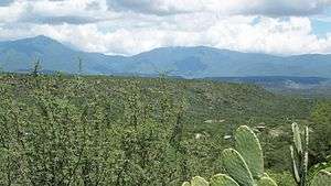
The coastal plains along the Gulf have a large presence in the state, whereas inland the landscape is adorned by cactus species and pasture. Predominant fauna in the region include the cougar (Puma concolor), long-tailed weasel (Mustela frenata), ocelot (Leopardus pardalis), American badger (Taxidea taxus), North American beaver (Castor canadensis), plain chachalaca (Ortalis vetula) and quail.
In the western part of the state, the Sierra Madre Oriental displays warm valleys and high sierras with peaks reaching 3,280 m (10,760 ft) in the Pedragoso Sierra; 3,240 m (10,630 ft) in the Borregos Sierra; 3,220 m (10,560 ft) in La Gloria Sierra; 3,180 m (10,430 ft) in Cerro el Nacimiento; and 3,000 m (9,800 ft) above sea level in the Sierra el Pinal. The Sierra de Tamaulipas and the Sierra de San Carlos are isolated mountain ranges in eastern Tamaulipas.
In terms of hydrology, the Bravo, Purificacion and Guayalejo rivers flow into the Gulf of Mexico after crossing the state from the western inland. On their way, their basins and zones of influence naturally correspond to the areas destined for agricultural use. The Rio Grande, known to Mexicans as the Río Bravo, represents the northern frontier shared with the United States. One of the tributaries of this natural border, the San Juan River, feeds the Falcon International Reservoir and the Marte Gomez Dam, which, in conjunction with the "Friendship Dam", reach a capacity of 12,940 million cubic meters of stored water. Agricultural and cattle raising activities are served by 14 other dams across the state, with a total capacity of 7,500 million cubic meters of water.
As much as 90% of the state reports a dry or semi-dry climate, while the Huasteca mountain range presents hot and semi-humid conditions, along with humid winds coming from the Gulf, which means it is located in a zone highly influenced by cyclones, with predominant winds coming from the east and southeast.
Government and infrastructure
State agencies include:
Economy and culture

Northern Tamaulipas shares its economic culture with that of Texas, and is primarily characterized by agriculture and strong growth in all industrial sectors. This region is home to many of the maquiladoras, factories owned by foreign companies but worked by Mexicans, primarily by women.
Southern Tamaulipas' economy is based primarily on the petrochemical industries. There are petrochemical production plants around Altamira as well as a principal Gulf coast container port, refinery facilities in Ciudad Madero and many oil-industry support service companies in Tampico, as well as a major general and bulk cargo port.[10] Also of importance are the tourism and fishing industries, as well as much commercial shipping, based in Tampico and Altamira. The little village of La Pesca, in the municipality of Soto La Marina, about midway between Brownsville, Texas and Tampico, is a rapidly growing tourist area with lovely beaches and excellent fishing both in the Gulf of Mexico and the Rio Soto La Marina. The central zone contains the capital, Ciudad Victoria, and is home to much forestry and farming, as well as some industrial development. About 30% of the population lives here, both in the capital and in Ciudad Mante. Ciudad Victoria is a significant educational center, home to the Autonomous University of Tamaulipas (which also has campuses in other cities in the state), the Regional Technical Institute of Ciudad Victoria, the University of Valle de Bravo, and other institutions of learning.
As of the 1990 Mexican census, 13 percent of the homes had only dirt floors, nearly 19 percent had no running water, and over 15 percent of the homes had no electricity. This was better than the national average, but was skewed because of the high rate of development in the urban centers. In rural communities in Tamaulipas, access to running water was available in less than 40 percent of homes.
As of 2005, Tamaulipas’s economy represents 3.3% of Mexico’s total gross domestic product or 21,664 million USD.[11] Tamaulipas's economy has a strong focus on export oriented manufacturing (i.e. maquiladora / INMEX). As of 2005, 258,762 people are employed in the manufacturing sector.[11] Foreign direct investment in Tamaulipas was 386.2 million USD for 2005. The average wage for an employee in Tamaulipas is approximately 240 pesos per day, $2.00 to $3.00 an hour.
Demographics
| Historical population | ||
|---|---|---|
| Year | Pop. | ±% |
| 1895[12] | 209,106 | — |
| 1900 | 218,948 | +4.7% |
| 1910 | 249,641 | +14.0% |
| 1921 | 286,904 | +14.9% |
| 1930 | 344,039 | +19.9% |
| 1940 | 458,832 | +33.4% |
| 1950 | 718,167 | +56.5% |
| 1960 | 1,024,182 | +42.6% |
| 1970 | 1,456,858 | +42.2% |
| 1980 | 1,924,484 | +32.1% |
| 1990 | 2,249,581 | +16.9% |
| 1995 | 2,527,328 | +12.3% |
| 2000 | 2,753,222 | +8.9% |
| 2005 | 3,024,238 | +9.8% |
| 2010 | 3,268,554 | +8.1% |
| 2015[13] | 3,441,698 | +5.3% |
| City | City Population[14] | Municipality Population | Metropolitan Population[15] | Metropolitan area type |
|---|---|---|---|---|
| Reynosa | 589,466 | 608,891 | 1,501,919[16] | International R/RB/H |
| Matamoros | 449,815[17] | 489,193 | 1,136,995[18] | International M/C |
| Nuevo Laredo | 373,725 | 384,033 | 636,516 | International NL/W/H/C |
| Ciudad Victoria | 305,155 | 321,953 | 321,953 | Municipality |
| Tampico | 297,284 | 309,003 | 859,419 | In and Out-of-state |
| Ciudad Madero | 197,216 | 197,216 | – | Part of Tampico Metro |
| Miramar | 118,614 | – | – | Part of Tampico Metro |
| Rio Bravo | 95,647 | 118,259 | – | Part of Reynosa Metro |
| Ciudad Mante | 84,787 | 115,792 | 115,792 | Municipality |
| Altamira | 59,536 | 212,001 | – | Part of Tampico Metro |
| Valle Hermoso | 48,918 | 63,170 | 63,170 | Municipality |
| Bustamante | 100 | 101 | 101 | Municipality |
Education
Tamaulipas enjoys standards slightly higher than the national averages, since illiteracy has been reduced to 5% for those over 15 years of age, average schooling reaches 7.8 years, and as many as 11% have earned a professional degree.
Institutions of higher education include:
- Instituto de Estudios Superiores de Tamaulipas (IEST)
- Instituto Tecnológico de Ciudad Madero (ITCM)
- Universidad Autónoma de Tamaulipas
Transportation
Airports
Tamaulipas is served by 5 international airports and one national airport.
- Ciudad Victoria is served by: General Pedro J. Méndez International Airport
- Matamoros is served by: General Servando Canales International Airport
- Nuevo Laredo is served by: Quetzalcóatl International Airport
- Reynosa is served by: General Lucio Blanco International Airport
- Tampico is served by: General Francisco Javier Mina International Airport
- Ciudad Mante is served by: Ciudad Mante National Airport
Notable natives and residents
- Intocable, Regional Mexican musical group
- Fito Olivares, Cumbia singer/musician
- Juan Garcia Abrego, drug criminal
- Rosemary Barkett, US judge
- James Carlos Blake, award-winning novelist
- José María Jesús Carbajal, Mexican freedom fighter, military governor of Tamaulipas
- Ana Brenda Contreras, actress, singer
- Alicja Bachleda-Curus, actress, singer
- Amalia González Caballero de Castillo Ledón, diplomat, cabinet minister, minister plenipotentiary, writer,
- Laura Elizondo, beauty queen/model
- Juan García Esquivel, composer/band leader/pianist
- Laura Flores, actress
- Rafael Aguilar Guajardo, drug criminal
- Manuel González Flores, general and politician who served as president of Mexico from 1880 to 1884.
- Max Appedole Film Producer, Author, Business man Politician, Activist.[19]
- Víctor García, singer
- Rodrigo González, musician and songwriter
- Emilio Portes Gil, president of Mexico after the death of Alvaro Obregon in 1928.
- Alejandro Gomez Monteverde, director/producer
- Manuel Raga, basketball player
- Aurora Robles, model
- James de La Rosa, welterweight boxer
- Juan de la Rosa, boxer on the NBC's show The Contender
- Arleth Terán, actress
- Rigo Tovar, singer/songwriter/composer/actor
- Ismael Valdez, former starting pitcher in Major League Baseball
- Eduardo Verástegui, actor/model
- B. Traven, German author and activist[20]
- Juan Nepomuceno Guerra, smuggler/founder of C.D.G.
- Mauricio Garces, actor
- Ivan Contreras, volleyball olympics
State anthem
The current anthem of the state of Tamaulipas is Himno a Tamaulipas, composed in 1926 by Rafael Antonio Pérez Pérez, set to music by Alfredo Tamayo Marín. Normally, only the chorus, first verse and chorus are sung in public.
|
Coro: |
Chorus: |
|
Estrofa I: |
Verse I: |
|
Estrofa II: |
Verse II: |
|
Estrofa III: |
Verse III: |
|
Estrofa IV: |
Verse IV: |
|
Estrofa V: |
Verse V: |
|
Estrofa VI: |
Verse VI: |
See also
References
- ↑ "Las Diputaciones Provinciales" (PDF) (in Spanish). p. 15.
- ↑ "Senadores por Tamaulipas LXI Legislatura". Senado de la Republica. Retrieved April 7, 2011.
- ↑ "Listado de Diputados por Grupo Parlamentario del Estado de Tamaulipas". Camara de Diputados. Retrieved April 7, 2011.
- ↑ "Resumen". Cuentame INEGI. Retrieved February 12, 2013.
- ↑ "Relieve". Cuentame INEGI. Retrieved April 7, 2011.
- ↑ "Encuesta Intercensal 2015" (PDF). Retrieved December 9, 2015.
- ↑ "Reporte: Jueves 3 de Junio del 2010. Cierre del peso mexicano". www.pesomexicano.com.mx. Retrieved August 10, 2010.
- ↑ "Tamaulipas" (PDF). SRE. Retrieved April 7, 2011.
- ↑ "Historia". Gobierno del Estado de Tamaulipas. Retrieved April 7, 2011.
- ↑ "Puerto de Tampico". Ports in Mexico. World Port Source. Retrieved 2009-12-17.
- 1 2 Industrial Costs in Mexico – A Guide for Foreign Investors 2007. Mexico City: Bancomext. 2007. p. 102.
- ↑ "Mexico: extended population list". GeoHive. Retrieved 2011-07-29.
- ↑ "Encuesta Intercensal 2015" (PDF). INEGI. Retrieved 2015-12-09.
- ↑ "Link to tables of population data from Census of 2010". Inegi.org.mx. Retrieved 2013-06-30.
- ↑ 2010 U.S. Census Data and Link to tables of population data from Census of 2010
- ↑ "McAllen Overview". McAllen Chamber of Commerce. Retrieved 26 August 2011.
- ↑ "Estadísticas INEGI Población en Matamoros". Copyright © 2011 matamoros.com.
- ↑ "Matamoros-Brownsville". World Gazetteer. Retrieved 22 August 2011.
- ↑ "Gloria (2014) Full Cast & Crew". IMDb. Retrieved May 30, 2016.
Max Appedole ... Executive Producer
- ↑ Tapio, Helen. "B. Traven's Identity Revisited". Helsinki Historia. Historical Association. Retrieved 17 June 2016.
- ↑ "HIMNO A TAMAULIPAS".
External links
| Wikimedia Commons has media related to Tamaulipas. |
 Geographic data related to Tamaulipas at OpenStreetMap
- Tamaulipas state government. (Spanish)
- Ley de Escudo de Armas y el Himno de Tamaulipas

