River Freshney
| River Freshney | |
| River | |
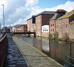 The old granary and riverside walk above Alexandra Dock | |
| Country | England |
|---|---|
| Counties | Lincolnshire |
| Source | |
| - location | Beelsby |
| Mouth | |
| - location | Grimsby Docks |
River Freshney | |||||||||||||||||||||||||||||||||||||||||||||||||||||||||||||||||||||||||||||||||||||||||||||||||||||||||||||||||||||||||||||||||||||||||||||||||||||||||||||||||||||||||||||||||||||||||||||||||||||||||||||||||||||||||||||||||||||||||||||||||||||||||||||||||||||||||||||||||||||||||||||||||
|---|---|---|---|---|---|---|---|---|---|---|---|---|---|---|---|---|---|---|---|---|---|---|---|---|---|---|---|---|---|---|---|---|---|---|---|---|---|---|---|---|---|---|---|---|---|---|---|---|---|---|---|---|---|---|---|---|---|---|---|---|---|---|---|---|---|---|---|---|---|---|---|---|---|---|---|---|---|---|---|---|---|---|---|---|---|---|---|---|---|---|---|---|---|---|---|---|---|---|---|---|---|---|---|---|---|---|---|---|---|---|---|---|---|---|---|---|---|---|---|---|---|---|---|---|---|---|---|---|---|---|---|---|---|---|---|---|---|---|---|---|---|---|---|---|---|---|---|---|---|---|---|---|---|---|---|---|---|---|---|---|---|---|---|---|---|---|---|---|---|---|---|---|---|---|---|---|---|---|---|---|---|---|---|---|---|---|---|---|---|---|---|---|---|---|---|---|---|---|---|---|---|---|---|---|---|---|---|---|---|---|---|---|---|---|---|---|---|---|---|---|---|---|---|---|---|---|---|---|---|---|---|---|---|---|---|---|---|---|---|---|---|---|---|---|---|---|---|---|---|---|---|---|---|---|---|---|---|---|---|---|---|---|---|---|---|---|---|---|---|---|---|---|---|---|---|---|---|---|---|---|---|---|---|---|---|---|---|---|---|
Legend
| |||||||||||||||||||||||||||||||||||||||||||||||||||||||||||||||||||||||||||||||||||||||||||||||||||||||||||||||||||||||||||||||||||||||||||||||||||||||||||||||||||||||||||||||||||||||||||||||||||||||||||||||||||||||||||||||||||||||||||||||||||||||||||||||||||||||||||||||||||||||||||||||||
The River Freshney is a river in the English county of North East Lincolnshire. The town of Grimsby stands on its banks. It rises from at least four springs on the edge of the Lincolnshire Wolds, although local folklore and oral tradition has it springing from Welbeck Hill. Originally it entered the tidal River Humber at Pyewipe, north west of Grimsby, but has been re-routed and now supplies Grimsby Docks. There was an existing haven within the borough of Grimsby but this suffered greatly with silting problems so in 1669 landowners agreed to the diversion of the Freshney through the town to the haven to provide fresh water and improve the flow. It is believed the work was completed in the very early 18th century.
Route
The river rises from a series of springs. The furthest south rises just to the north of Beelsby, close to the 200-foot (60 m) contour. It flows north and is joined by another stream which flows past some earthworks, dating from the English Civil War, before both pass under the A18 Laceby to Barnoldby le Beck road. Team Gate Drain rises just to the west of Waltham and flows to the west. It is joined by the stream from Welbeck Hill, which rises close to the A18 road and the 65-foot (20 m) contour. Having combined, they flow northwards, passing under the A46 road and the old course of the road through Laceby, both of which are called Grimsby Road. The river is called Laceby Beck as it flows along the eastern edge of Laceby.[1]
Another stream from Aylesby joins before it passes between some lakes at Laceby Acres. The New Cut Drain runs parallel to the river from here, and they pass under the A1136 road and either side of the Freshney Bog Nature Reserve. Cromwell Road and the railway line to Grimsby cross in quick succession, after which the New Cut Drain follows the original course of the river, while the river turns sharply under the railway line to the docks, and under a series of bridges in Grimsby. These carry Boulevard Avenue, Earl Street and Alexandra Road over the channel. Another sharp turn brings the river into Alexandra Dock.[1] There is a sluice with flap doors on it across the river at this point, and Freshney pumping station assists the discharge when water level prevent gravity discharge. Corporation Bridge is a grade II listed Scherzer rolling lift bridge and carries Corporation Road over the dock. It was designed by Alfred C Gardner, the Docks Engineer for the London and North Eastern Railway, and was installed in 1925 by Sir William Arrol & Co., an engineering company based in Glasgow. It has four cast iron and steel spans, one of which opens, and the structure, which replaced the previous swing bridge,[2] was formally opened by the Prince of Wales on 19 July 1928.[3] After the A180 Westgate road crosses Alexandra Dock, Union Dock connects it to Royal Dock, at the end of which a lock connects it to the Humber.[1] The Friends of the Freshney was formed in the 2000s under the Chairmanship of Chris Scott, and primarily concerns itself with the stretch of river that goes through the Duke of York Gardens in Grimsby. The group currently meets in the MAAG Hall, Haycroft Street on the last Monday in the month at 6pm.
Hydrology
Freshney Bog was constructed in 2001 as a washland, which could be used to hold excess water when the channel below it could not cope with the flow in the river. It is a major part of the flood defence system for Grimsby. During the floods of 2007, more than a full month's rainfall fell in 24 hours on the river catchment. Groundwater levels rose by over 16 feet (4.9 m) in the week prior to the floods, and with the ground saturated, the capacity of the river and the New Cut Drain was exceeded. Freshney Bog storage area filled up, but had insufficient capacity for the volume of water, and as a result, flooding occurred, which affected 90 houses.[4] At Laceby Beck gauging station, normal levels of the river vary between 0.62 and 2.55 feet (0.19 and 0.78 m), but on 21 June 2007, they reached 3.25 feet (0.99 m). Although flooding resulted, the level was well below the maximum recorded level of 7.96 feet (2.43 m) at this location.[5]
Points of interest
| Point | Coordinates (Links to map resources) |
OS Grid Ref | Notes |
|---|---|---|---|
| Royal Dock lock | 53°35′00″N 0°04′14″W / 53.5832°N 0.0705°W | TA278113 | mouth |
| Discharge into Alexandra Dock | 53°34′03″N 0°05′00″W / 53.5676°N 0.0833°W | TA270095 | |
| Diversion from original course | 53°34′30″N 0°06′35″W / 53.5749°N 0.1097°W | TA252103 | |
| New Cut Drain joins Humber | 53°34′52″N 0°05′35″W / 53.5810°N 0.0931°W | TA263110 | original mouth |
| A1136 bridge | 53°33′50″N 0°07′45″W / 53.5639°N 0.1292°W | TA240091 | |
| Laceby Acres | 53°33′16″N 0°08′50″W / 53.5544°N 0.1473°W | TA228080 | |
| Junction with Team Gate Drain | 53°31′39″N 0°09′25″W / 53.5276°N 0.1569°W | TA222050 | |
| Welbeck Hill spring | 53°31′09″N 0°09′39″W / 53.5191°N 0.1609°W | TA220040 | traditional source |
| Beelsby spring | 53°30′11″N 0°10′28″W / 53.5031°N 0.1744°W | TA211022 | source |
See also
References
- 1 2 3 Ordnance Survey, 1:50,000 map
- ↑ Historic England. "Corporation Bridge (478815)". Images of England.
- ↑ Cast iron plate on eastern end of bridge
- ↑ "River Freshney". Environment Agency. 2010.
- ↑ "Laceby Beck at River Freshney Grimsby". Environment Agency.
| Rivers | |
|---|---|