River Twiss
| River Twiss | |
|---|---|
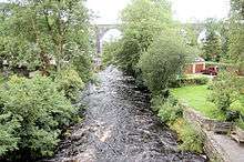 River Twiss and Ingleton Viaduct | |
| Country | England |
| Basin | |
| Main source |
Kingsdale Beck, Keld Head 264 metres (866 ft) 54°11′3″N 2°28′4″W / 54.18417°N 2.46778°W |
| River mouth |
River Doe 118 metres (387 ft) 54°9′11″N 2°28′15″W / 54.15306°N 2.47083°WCoordinates: 54°9′11″N 2°28′15″W / 54.15306°N 2.47083°W |
| Physical characteristics | |
| Length | 4.17 kilometres (2.59 mi) |
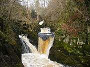
The River Twiss is a river in the county of Yorkshire, England. The source of the river is Kingsdale Beck which rises at Kingsdale Head at the confluence of Back Gill and Long Gill in the Yorkshire Dales. Beneath Keld Head, it changes its name to the River Twiss. It has two notable waterfalls, Thornton Force and Pecca Falls, and its course follows part of the Ingleton Waterfalls Walk,[1] then through Swilla Glen to Thornton in Lonsdale and down to Ingleton, where it meets the River Doe to form the River Greta.
The English landscape artist J. M. W. Turner was a frequent visitor to the area and his sketch of Thornton Force in 1816 is currently part of the Tate collection.[2]
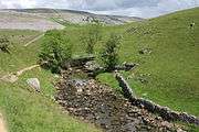
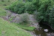
Course
From the caves below Keld Head there is a flow of water that joins Kingsdale Beck to form the River Twiss. It flows south over Thornton Force and Pecca Falls and through woodland to join the River Doe at Ingleton.[3]
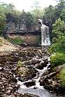
Waterfalls
The drop of Thornton Force is about 14 metres (46 ft). Pecca Falls has three drops totalling 30 metres (98 ft) that fall into their own deep pools.[4]
Geology
In its upper part the river runs through a valley cut into horizontal beds of Carboniferous Great Scar limestone. At Thornton Force it crosses a notable unconformity into the underlying, steeply inclined Ordovician greywackes. The unconformity is clearly visible in the face of the waterfall. The Ordovician strata influence the character of the steep and narrow Swilla Glen and its waterfalls until, just north of Ingleton, the river crosses the Craven Fault and onto Carboniferous Limestone once again.[4]
Crossings
- Ravenray Bridge (foot)
- Pecca Bridge (foot)
- Manor Bridge (foot)
- Unnamed Road, Ingleton
Gallery
| River Twiss Images | ||||||||||||
|---|---|---|---|---|---|---|---|---|---|---|---|---|
|


Sources
References
- ↑ "Ingleton Waterfalls Walk". Retrieved 20 August 2011.
- ↑ "Landscape". Retrieved 20 August 2011.
- ↑ "River course" (PDF). Retrieved 20 August 2011.
- 1 2 "Waterfalls". Retrieved 20 August 2011.