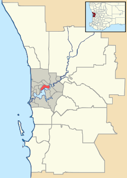
Rivervale, Western Australia
| Rivervale Perth, Western Australia | |||||||||||||
|---|---|---|---|---|---|---|---|---|---|---|---|---|---|
 Rivervale | |||||||||||||
| Coordinates | 31°57′40″S 115°55′01″E / 31.961°S 115.917°ECoordinates: 31°57′40″S 115°55′01″E / 31.961°S 115.917°E | ||||||||||||
| Population | 7,070 (2006 census)[1] | ||||||||||||
| Established | 1843 | ||||||||||||
| Postcode(s) | 6103 | ||||||||||||
| Location | 5 km (3 mi) from Perth | ||||||||||||
| LGA(s) | City of Belmont | ||||||||||||
| State electorate(s) | Belmont | ||||||||||||
| Federal Division(s) | Swan | ||||||||||||
| |||||||||||||
Rivervale, near the Swan River, is a suburb of Perth, Western Australia and 5 km from Perth's central business district.
Rivervale was known as Barndon Hill until 1884.[2]
References
- ↑ Australian Bureau of Statistics (25 October 2007). "Rivervale (State Suburb)". 2006 Census QuickStats. Retrieved 2008-10-05.
- ↑ Western Australian Land Information Authority. "History of metropolitan suburb names – R". Retrieved 2008-08-04.
This article is issued from Wikipedia - version of the 12/16/2015. The text is available under the Creative Commons Attribution/Share Alike but additional terms may apply for the media files.