Rožňava District
| Rožňava District | |
|---|---|
| District | |
 | |
| Country | Slovakia |
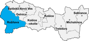
| Region (kraj) | Košice Region |
| Area | |
| • Total | 1,173 km2 (453 sq mi) |
| Population (2001) | |
| • Total | 61,887 |
| • Density | 53/km2 (140/sq mi) |
| Time zone | CET (UTC+1) |
| • Summer (DST) | CEST (UTC+2) |
| Telephone prefix | 058 |
Rožňava District (okres Rožňava) is a district in the Košice Region of eastern Slovakia. Until 1918, the district was mostly part of the county of Kingdom of Hungary of Gömör és Kishont, apart from the area in the south-east around the municipalities of Silická Jablonica, Hrušov, Jablonov nad Turňou and Hrhov which formed part of the county of Abaúj-Torna.
Municipalities
- Ardovo
- Betliar
- Bohúňovo
- Bôrka
- Brdárka
- Bretka
- Brzotín
- Čierna Lehota
- Čoltovo
- Čučma
- Dedinky
- Dlhá Ves
- Dobšiná
- Drnava
- Gemerská Hôrka
- Gemerská Panica
- Gemerská Poloma
- Gočaltovo
- Gočovo
- Hanková
- Henckovce
- Honce
- Hrhov
- Hrušov
- Jablonov nad Turňou
- Jovice
- Kečovo
- Kobeliarovo
- Koceľovce
- Kováčová
- Krásnohorská Dlhá Lúka
- Krásnohorské Podhradie
- Kružná
- Kunova Teplica
- Lipovník
- Lúčka
- Markuška
- Meliata
- Nižná Slaná
- Ochtiná
- Pača
- Pašková
- Petrovo
- Plešivec
- Rakovnica
- Rejdová
- Rochovce
- Roštár
- Rozložná
- Rožňava
- Rožňavské Bystré
- Rudná
- Silica
- Silická Brezová
- Silická Jablonica
- Slavec
- Slavoška
- Slavošovce
- Stratená
- Štítnik
- Vlachovo
- Vyšná Slaná
Districts of Košice Region | ||
|---|---|---|
Coordinates: 48°39′46″N 20°32′2″E / 48.66278°N 20.53389°E
This article is issued from Wikipedia - version of the 3/28/2013. The text is available under the Creative Commons Attribution/Share Alike but additional terms may apply for the media files.