Road surface marking

Road surface marking is any kind of device or material that is used on a road surface in order to convey official information. They can also be applied in other facilities used by vehicles to mark parking spaces or designate areas for other uses.
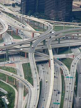
Road surface markings are used on paved roadways to provide guidance and information to drivers and pedestrians. Uniformity of the markings is an important factor in minimizing confusion and uncertainty about their meaning, and efforts exist to standardize such markings across borders. However, countries and areas categorize and specify road surface markings in different ways.
Road surface markings are either mechanical, non-mechanical, or temporary. They can be used to delineate traffic lanes, inform motorists and pedestrians or serve as noise generators when run across a road, or attempt to wake a sleeping driver when installed in the shoulders of a road. Road surface marking can also indicate regulation for parking and stopping.
There is continuous effort to improve the road marking system, and technological breakthroughs include adding retroreflectivity, increasing longevity, and lowering installation cost.
History
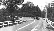
In the United States, the first documented use of a painted center line was in 1911 along Trenton's River Road in Wayne County, Michigan.[1] According to the state of Michigan, the idea of using a painted center line was conceived in 1911 by Edward N. Hines, the chairman of the Wayne County, Michigan, Board of Roads,[2] after watching a leaky milk wagon leave a white trail along a road.[1] Hines was the fifth recipient of the George S. Bartlett Award for Highway Progress,[3] and was inducted posthumously in 1972 into the Michigan Transportation Hall of Honor for his innovation, and was honored in 2011 with the first Paul Mijksenaar Design for Function Award.[1]
In 1917, the idea of using painted center lines on rural state highways was conceived and/or put into action in at least three states (Michigan, Oregon, and California), apparently completely independent of one another.[4] At some point in 1917, a white highway center line was painted along "Dead Man's Curve" on what is now County Road 492 in Marquette County, Michigan,[1] under the direction of Kenneth Ingalls Sawyer, who served as engineer-superintendent of the Marquette County Road Commission.[5][6][7] Sawyer was inducted posthumously into the Michigan Transportation Hall of Honor in 1973.[8]
In Oregon in April 1917, a yellow center line was painted down the center of the Columbia River Highway, between Crown Point and Multnomah Falls, at the direction of Multnomah County Sheriff's Deputy Peter Rexford.[9] Later in 1917, the same line was continued west of Crown Point.[9] Rexford first conceived the idea of a yellow center line in early 1917 while riding on a bus from Salem, Oregon on a dark and rainy night,[10] and advocated it as a safety measure on the Columbia River Highway, which Rexford patrolled as a traffic officer.[11] When Multnomah County declined to fund the project, Rexford's boss, Chief Deputy Martin T. Pratt (later elected Sheriff), paid for the paint out of his own pocket so that the center line could be painted.[11][12][13] Rexford later described the April 1917 line as the "first yellow center line ever painted on pavement" in the United States.[9] An article published in The Oregonian upon Rexford's retirement claimed that a contest with a $10,000 reward was once held to determine the originator of the highway center line, but the contest was scrapped when information from Europe revealed that ancient civilizations had used white bricks to mark the center lines of their streets.[10]
In the fall of 1917, Dr. June McCarroll of Indio, California developed the idea of white center lines and began advocating for their use, after she was run off the road by a truck while driving along a highway that would later be incorporated into U.S. Route 99.[14] Dr. McCarroll soon communicated her idea to the local chamber of commerce and the Riverside County Board of Supervisors, with no success. She then took it upon herself to hand-paint a white stripe down the middle of the road, thus establishing the actual width of the lane to prevent similar accidents.[15] In 2002, a portion of Interstate 10 was designated and signed as "The Doctor June McCarroll Memorial Freeway" in her honor.[15]
The question of which color to use for highway center lines in the United States enjoyed considerable debate and changing standards over a period of several decades. By November 1954, 47 states had adopted white as their standard color for highway centerlines, with Oregon being the last holdout to use yellow.[4] In 1958, the U.S. Bureau of Public Roads adopted white as the standard color for the new interstate highway system.[16] The 1971 edition of the Manual on Uniform Traffic Control Devices, however, mandated yellow as the standard color of center lines nationwide. The changeover to the 1971 MUTCD standards took place between 1971 and 1975, with most done by the end of 1973, so for two years drivers still had to use the old and new. Yellow was adopted because it was already the standard color of warning signs, and because it was easy to teach drivers to associate yellow lines with dividing opposing traffic and white lines with dividing traffic in the same direction. In turn, this simple mnemonic device greatly reduced head-on collisions and improved road traffic safety.
The major downside to the MUTCD white-yellow system is that yellow has slightly less contrast than white, especially at night, so for maximum contrast, bright yellow—and highly toxic—lead chromate was used to paint yellow lines through the end of the 20th century. As a result, U.S. transportation workers must take special precautions when disturbing or removing yellow lane markings.[17]
In England, the idea of painting a center white line was first experimented with in 1921 in Sutton Coldfield, Birmingham. Following complaints by residents over reckless driving and several collisions, the Sutton Coldfield Corporation decided to paint the line on Maney Corner in the area of Maney.[18]
In 1971, a correspondent for the Sutton Coldfield News wrote an article in the newspaper recalling the event.
The line was put down as an experiment as there were a lot of accidents there, even in the early days of the motor car. The experiment proved to be so successful that the whole country adopted it as a standard road safety device, and later foreign countries paint lines on their roads, as well.
In November 2014, a glow-in-the-dark bike path inspired by Vincent van Gogh's The Starry Night was created with luminous paint in the Netherlands with the intent to reduce urban light pollution.[19]
Today, road markings are used to convey a range of information to the driver spanning navigational, safety and enforcement issues leading to their use in road environment understanding within advanced driver assistance systems and consideration for future use in autonomous road vehicles.[20]
Mechanical markers
Mechanical devices may be raised or recessed into the road surface, and either reflective or non-reflective. Most are permanent; some are movable.
- Cat's eye, invented by Percy Shaw in the 1930s, Cat's eyes equip many major routes in the British Isles. They consist of four reflective lenses mounted in a durable white rubber housing, two facing fore and two facing aft. The housing is mounted within a cast iron shoe, which the rubber housing sinks in to when driven over. This provides protection from snow ploughing and allows the lenses to be self-cleaning—they pass a rubber blade when depressed. The lenses are available in a variety of different colours, mainly white, yellow/orange, green, red, and blue.
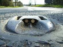
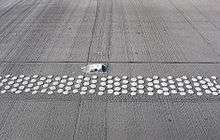
- Botts' dots (low rounded white dots), named for the California Caltrans engineer Elbert Botts, who invented the epoxy that keeps them glued down, are one type of a mechanical non-reflective raised marker. Generally they are used to mark the edges of traffic lanes, frequently in conjunction with raised reflective markers. Botts' dots are also used across a travel lane to draw the drivers attention to the road. They are frequently used in this way to alert drivers to toll booths, school zones or other significant reduction of speed limit. They are normally only used in warm climates since snow plows usually remove them along with the snow.
- Rumble strips are commonly used for the same purpose. A rumble strip can be a series of simple troughs (typically 1 cm deep and 10 cm wide) that is ground out of the asphalt. Other alternatives, similar to the Botts' dots, use raised strips, painted or glued to the surface. A specific form of raised strips using thermoplastic is called profile thermoplastic markings. The markings are created by fusing thermoplastic to the pavement and create alternating elevation and recession pattern. This can be done as inverted-profile markings or raised-profile markings. Inverted-profile markings are created by pressing a cog rolling over the markings while they are wet to make them corrugated. Raised-profile markings are created by extruding extra thickness of thermoplastic at a specific interval to create bumps.[21] Raised-profile markings are sometime known as convex traffic lines.[22] Uses of rumble strips can be across the travel direction (to warn of hazards ahead) or along the travel direction (to warn of hazards of not staying within a specific lane).[23] Their main way of function is creating a strong vibration when driven over that will alert a driver to various upcoming hazards both by sound and the physical vibration of the vehicle. In some areas in the United States, these rumble strips are located along the side of county, state, and inter state highways. They are oriented so that a driver wandering off the lane of traffic would come in contact with these strips and be forewarned that they are about to leave the roadway. The idea was first started in Atlanta, as a measure to help truck drivers on the bypass after a number of accidents in the late 1980s involved drivers who became distracted or fell asleep and left the road.
- Reflective markers are used as travel lane dividers, to mark the central reservation (median) or to mark exit slip-roads. Incorporating a raised retro-reflective element, they are typically more visible at night and in inclement weather than standard road marking lines. The color of markers varies depending on the country of use; freeways in the United States often use reflectors manufactured to appear white to drivers proceeding in the proper direction of travel, and appear red on the reverse to warn drivers that they are proceeding against the proper direction of travel, creating a danger of a head-on collision. Reflective markers are also referred to as raised pavement markers, road studs, and sometimes (generically) in the UK and Ireland as cat's eye, although this name refers to one particular brand of product. These markers can be used for other purposes such as marking the locations of fire hydrants (blue) or at gates of gated communities to indicate that emergency service vehicles have a code or device that allows them to open the gate. In the United Kingdom and elsewhere, raised markers are used to mark crosswalks (crossings) to assist the blind in crossing streets. In colder climates, reflective markers may be installed below ground using an elongated narrow triangle, cut into the road surface that allows the device to be installed below the road surface. Newer technology allows these to be placed above ground with snowplough-able rails that attempt to protect the reflective components from the snowplough blade.
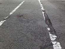
Confusion with marks left by roadwork

Sometimes the result of roadwork may leave some marks on the pavements. An example is the dowel bar retrofit process to reinforce concrete slabs in order to extend the life of the older concrete pavements. The completion of the process leaves a symmetrical pattern of dash marks on the roadway as if there are associated meaning to the pattern.[25] Motorists may interpret them as an unknown form mechanical markers, or strange road surface markings when there are many of them along the roadway.[26] In some cases, these marks create some confusions to motorists. When the roads are under construction and the lanes are shifted, those marks may interfere with lane markings. As the marks from the dowel bar retrofit are not intended to be any form of road surface markings, the responsible agencies try to make these marks less visible to the motorists as possible.[27]
Non-mechanical markers
Paint
Paint, sometimes with additives such as retroreflective glass beads,[28] is generally used to mark travel lanes. It is also used to mark spaces in parking lots or special purpose spaces for disabled parking, loading zones, or time-restricted parking areas. Colors for these applications vary by locality. Paint is a low-cost marking and has been in widespread use since approximately the early 1950s.
Paint consists of three main components: pigments, resins or binders, and water or solvents. Pigments are finely grounded materials that give out colors or block out the surface beneath it. They may contain other materials such as UV stabilizer, and fillers which bring out the color pigments to the required level. Resins or binders are the glue of the paint to bind pigment and glass beads together to the road surface. The resins for the water-based paints are polyvinyl acetate latex, methyl methacrylate or acrylic resin. The resins for solvent-based paints are linseed or soya oils and alkyd resins. The pigments and resins are mixed with water for water-based paints and solvents for solvent-based paints so that they can be applied onto the road surface. Solvents that are use can be naphtha, toluene, methanol, methylene chloride, and acetone. Due to environmental concerns, some jurisdictions has some restriction on the solvent-based paints.[29]
_of_Pigment_Yellow_10.png) Pigment Yellow 10 is a common yellow colorant used for road marking on U.S. highways.[30]
Pigment Yellow 10 is a common yellow colorant used for road marking on U.S. highways.[30]
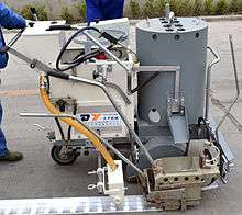
Paint is usually applied right after the road has been paved. The road is marked commonly by a truck called a "Striper." These trucks contain hundreds of gallons of paint stored in huge drums which sit on the bed. The markings are controlled manually or automatically by the controller who sits on the bed. Paint is run through a series of hoses under air pressure and applied to the roadway surface along with the application of glass beads for retroreflectivity. After application, the paint dries fairly quickly. Sometimes the glass beads are mixed in with the paint and apply together which is not a recommended method. The usual method is to use a separate gun to spray the glass beads on to the wet paint during the application.[29]
Painted symbols, such as turn-lane arrows or HOV lane markers, are applied manually using stencils. Painted markings usually last 9 to 36 months. There are some water-based paints that can be applied at double the level of thickness than typical latex paints. This technique can extend the life of the markings.[31]
Thermoplastic
One of the most common types of road marking based on its balance between cost and performance longevity, thermoplastic binder systems are generally based on one of three core chemistries: hydrocarbons, rosin esters or maleic modified rosin esters (MMRE). Thermoplastic coatings are generally homogeneous dry mixes of binder resins, plasticizers, glass beads (or other optics), pigments, and fillers. Their use has increased over paints mainly due to the performance benefits of increased durability, retro-reflectivity, and a lack of VOC solvents.
Thermoplastic markings are applied using specially designed vehicles. Usually thermoplastic marking mode should apply with equipment called road marking machine to coating traffic lines, and the road paint needs preheating by a device commonly called a preheater. The thermoplastic mix is heated in trucks to about 200 °C (400 °F) before being fed to the application apparatus. This is often a screed box or ribbon gun. Immediately after the thermoplastic has been applied, glass beads are laid onto the hot material so that they embed before the plastic hardens. These beads provide initial retroreflection. As the marking wears during use and the initial beads are lost, the beads mixed with the binder are uncovered, providing long term retroreflectivity. Most thermoplastic is produced in white and yellow colors, but other colors such as red may also be produced.
In the warm climate areas, the thermoplastic markings can last 3 to 6 years. However, snowplows can damage the thermoplastics which would limit the usage in the cold climate areas.[31]
Preformed thermoplastic
Preformed thermoplastic pavement markings (sometime called "tape", but not to be confused with preformed polymer tape) are thermoplastic cut into the final shapes by the manufacturers and ready to position onto an asphalt or concrete pavement surface. Preformed thermoplastics are put into place on the road surface and applied using a propane heat torch. Some models require heating the road surface prior to the placement of the preformed thermoplastics. These markings are used primarily because of their durability and cost-effective service life. As the plastics are melted into the surface, therefore they are not easily damaged by the snowplows. Typically, the preformed thermoplastic markings can last 3 to 6 years. The most common applications of preformed thermoplastic pavement markings are found at intersections as transverse markings such as stop lines, legends, crosswalks, arrows, bike lane symbols, and accessibility symbols.[29][31]
Preformed polymer tape
Commonly referred to as tape or cold plastic, this product is heavy-grade material with reflective beads embedded in the plastic. It is commonly used to mark crosswalks, stop bars, and traffic guidance such as turn lanes, HOV lanes, train crossings, pedestrian crossings, taxi lanes, bus lanes, and bike lanes. There are two ways to apply tape:
- Overlay—The application being laid over the surface of the pavement. Using industrial-grade rubber cement, once the tape is combined with the pavement, it should last three years. Major obstacles to estimated life are snow-plows, salt, and mis-application.
- Inlay—The tape physically becomes part of the asphalt. Using the heat generated in the paving process, road workers lay special tape on the asphalt in the hardening process, and rollers compress the two together.
The life of the preformed polymer tapes can vary based on the applications. If applied correctly, they can last between 4 and 8 years.[31] However, there have been cases where tape failures start soon after the installation. Conditions that may contribute to the tapes to peel off are the time of year of the installation that is too close to the winter, surface preparation, and workmanship. A technique that can be used to minimize the tape getting scraped off by snowplows is sandblasting a groove into the surface and fixing the tape onto this groove. This technique diminishes the advantage of low labor cost of the tapes.[32] The preformed polymer tape markings are slippery when wet, especially in large sections such as crosswalks, and caution should be used due to poor wet traction.
Epoxy
Epoxy contains two parts which are a pigmented resin base and catalyst. The two parts are mixed in a specialized truck for epoxy marking application. The epoxy is then heated prior to spraying onto road surface. Retroreflective glass beads are applied using a separate bead gun behind the epoxy spray gun. Typically, epoxy markings last about 4 years.[31]
Epoxy has been in use since the late 1970s and has gained popularity over the 1990s as the technology has become more affordable and reliable. This material competes directly with plastic with respect to usage and cost.[33]
Negative impacts to road surface
Non-mechanical markers are found to contribute to the deterioration of asphalt concrete road surface courses. The paint and tape markers can cause the road surface to crack, and in more severe cases, the markers contribute to road surface raveling[34] (a process in which the aggregate particles are dislodged from the road surface, causing the surface texture to become deeply pitted and very rough[35]) or potholes.
This type of surface damage can be found exclusively underneath the pavement markings such as lane markings and turn-lane arrows. There is no definitive explanation of the relationship between pavement markings and surface deterioration, but there are several hypotheses. One is that water vapor may have been trapped underneath the road surface markings, causing the de-bonding of asphalt binder from the aggregate materials. Another hypothesis is that the reflectivity of the markings may create differences in solar heating and thermal expansion strains between the areas with and without markings. Small flaws caused by differential strains may be combined into longitudinal cracks along the markings. There are certain surface treatments that can make the road surface less susceptible to this type of distresses, such as slurry seals and stone mastic asphalt.[34]
Temporary markers
Pylons are sometimes used to separate HOV lanes from regular traffic lanes. They are also used in areas where lanes are used at different times for travel in both directions. These pylons have shafts that drop into holes in the road surface. A good example of this type of use was the Golden Gate Bridge in San Francisco, before they switched to a moveable barrier system.
Removable tapes can also be used in road construction sites as temporary markers. The tapes can be placed to shift the lanes and black tapes can be used to temporarily blackout the existing markings. At the end of the constructions or within 6 months, the tapes can be pulled out off the surface without using heat, solvents, or machines.[29]
Country specific information
The Americas
Most countries in North and South America have yellow lines separating traffic directions. However, Chile uses white lines.
Canada
Generally speaking, Canadian pavement marking standards are consistent with those used throughout the United States.
Yellow lines are used to separate traffic moving in opposite directions, and white lines are used to separate traffic moving in the same direction, and on the shoulders of paved roads. On one-directional roads, a yellow line appears on the left shoulder, and a white line on the right shoulder. Passing rules are denoted by dashed lines as in the United States. Orange painted lines are sometimes used when the direction of the road is altered temporarily for construction projects. However, the colour scheme was reversed before 1971, when white was formerly used to denote the separation of opposing traffic, and yellow lines, when used, to denote the separation of the paved road from the right-hand shoulder.[36] Canada adopted similar road marking standards to conform with those adopted in the USA between 1971 and 1978.
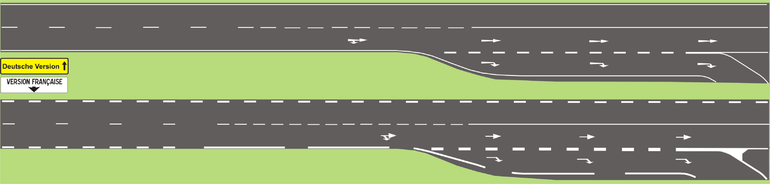
Broken lines that are wider and closer together than regular broken lines are called continuity lines. Continuity lines on the left side of a lane denote that the lane is about to end and that motorists must soon merge left. Continuity lines on the right mean that the lane will continue, but traffic may merge into it ahead.[37]
In some areas, reflective markers (cat's eyes) recessed into the pavement are used, especially approaching curves in the road.
Ontario has several pavement marking test areas located in various parts of the province. Perhaps the most well-known location is the eastbound lanes of Highway 401 near Belleville. Other test sites are located on the westbound lanes on Highway 417, east of Ottawa, Highway 60 West of Renfrew, Highway 28 east of Bancroft, Highway 69 North of Honey Harbour and on Highway 37, South of Tweed. Pavement marking manufacturers from around the world supply a variety of materials for these sites to have their products evaluated and approved for use on provincial highways.[38]
United States

In the U.S., the type, placement, and graphic standards of traffic signs, and road surfaces are legally regulated—the Federal Highway Administration's Manual on Uniform Traffic Control Devices is the standard, although each state produces its own manual based upon the Federal manual.[39]
Generally white lane markings indicate a separation between lanes traveling in the same direction while yellow markings indicate opposing traffic on the other side of the line. In some areas, such as Colorado and Florida, black material is applied on the surface before a shorter white line is painted. This improves the contrast of the marking against "white" pavements, such as concrete or faded asphalt.
In California, Botts' dots are commonly used to mark lanes on most freeways. A large number of California cities also use Botts' dots on some (or all) major arterial roads. The notable exception is the city of Los Angeles which only uses paint.
In California and Nevada, the reflectors when present are usually the lines, and no paint is used for additional markings. Exceptions include: freeways built from white concrete where painted stripes are added to make the lanes more visible through sun glare, freeways built so wide that the risk of drifting is minimal (e.g., Interstate 5 in the Central Valley), and freeways in areas where it snows in the winter (since the snowplows would scrape off the Botts' dots).
In general, single broken lines mean passing or lane changing is allowed, single solid white lines mean lane changing is discouraged but not prohibited, and double solid white lines mean it is prohibited,[40] as it often is in tunnels. On two-lane roads, a single broken center line means that passing is allowed in either direction, a double solid center line means passing is prohibited in both directions, and the combination of a solid line with a broken line means that passing is allowed only from the side with the broken line and prohibited from the side with the solid line.[40] The solid white line on the right side is called the Fog Line used to help cars stay in their lane during foggy conditions and help pedestrians stay off the road [41]
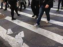
Marked crosswalks are indicated at a minimum by a pair of white lines. On major boulevards, crosswalks are further highlighted by zebra stripes, which are large white rectangles in the crosswalk perpendicular to traffic. In order to maximize the longevity of zebra crossing stripes, they are usually applied to correspond with the portions of the lane on which the wheels of a car are not usually traveling, thereby reducing wear on the markings themselves.
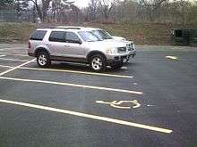
Pavement markings are used in addition to signs in the United States to designate regular and handicap parking spaces. Regular parking spaces are normally marked with white, although other colors are used. Handicap parking spaces are required to be located within a specified distance of an entrance. Blue markings are used to indicate the parking space is reserved for persons with a disabled parking permit.[42]
Asia
Hong Kong
Road markings in Hong Kong is basically identical with the United Kingdom, with longer dashed white lines to indicate lanes of opposing traffic, and shorter dashed white lines for lanes in the same direction. Solid double white lines are used to indicate that drivers are not permitted to change lanes. A solid white line with a broken white line indicates that crossing the line is allowed from the lane closer to the broken line. Double solid white lines are in place in all tunnels and underpasses.
As in the UK, solid yellow lines are painted along the kerbside to indicate that no parking is allowed, with double solid yellow lines meaning no parking is allowed at any time. Zig-zag lines are used on both ends of zebra crossings. Road studs are also used as in the UK.[43]
Japan
In Japan, white always separates traffic in the same direction or indicates traffic in the same direction can use a buffered area that is striped in crosshatch patterns such as at right turns on two-way roads since Japan is a country that has left-side driving.
White is also used on divided expressways with a solid raised center divider. Two-lane expressways where poles are the only physical barrier between opposing directions of travel always have yellow either side of the row of poles, and white is between the yellow striping and the poles.
White is also used to denote passing allowed on other two-lane roads. Yellow indicates no passing is allowed. On all roads, yellow stripes are always solid.
On expressways where there are many sharp turns and curves, seen especially in the largest cities, a yellow line indicates no passing between lanes, as follows:
- Solid yellow beside solid white: no entry permitted from the lane the stripe is next to, but passing is permitted with caution.
- Solid yellow beside broken white: passing is permitted from the side with the broken white line, but not from the side with the yellow line.
- Solid yellow line alone: passing prohibited from either lane, used on very tight curves and in tunnels.
Other markings include in the cities, destination and exit names painted in the lanes, which is done due to the very close proximity of exits, where in many cases it would be impractical to put up many overhead signs, although these are often seen approaching exits, a curved or slanted arrow points to the side of the expressway the exit will be on. A straight arrow following characters indicates the destination of the expressway.
Where a solid white line appears between lanes, passing is generally allowed but with caution.
Europe
In general European countries follow the Vienna Convention on Road Signs and Signals, which describes what road signs and road markings shall look like. The convention has some flexibility so road markings vary somewhat between the countries.
Most European countries reserve white for routine lane markings of any kind. Yellow is used to mark forbidden parking, such as on bus stops. However, for example Norway has yellow markings separating traffic directions. Many countries use yellow, orange, or red to indicate when lanes are being shifted temporarily to make room for construction projects.
In the Netherlands, Germany, Sweden, and the UK, so-called "naked roads" have been trialed, whereby all visible road markings, kerbs, traffic lights, and signs are removed, on urban roads. When this was tested in Seend, a village in the UK county of Wiltshire in 2005, the county council reported that accidents fell by a third, with motorists' speed falling by an average of 5%. It has been suggested that naked roads force drivers to make eye contact with other road users, and that it is this nonverbal communication that is responsible for the reduction of accidents.[44] Other have suggested that road markings, especially with middle marker, make the road look like a main road, triggering faster and more relaxed driving, while no marking makes the road look like a lower quality road.
It is an experience from the introduction of marking, that at least on narrow roads and in curves, middle lines help make drivers stay on their side when meeting, and therefore reducing meeting accidents. Note that the 2005 experiment was on urban roads. In Sweden, local streets generally have no marking.
Norway
In Norway, yellow lines are used to separate traffic moving in opposite directions and on the left shoulders of paved roads, and white lines are used to separate traffic moving in the same direction, and on the right shoulders of paved roads. On roads narrower than six metres (20 ft), the centerline is removed, and the shoulder lines are broken. Short, broken lines means passing is allowed, long, broken lines means passing is allowed but dangerous, and a double yellow line means passing is forbidden. Roads with speed limits below 60 km/h that indicate that passing is allowed but dangerous, has a very short yellow line instead of a long one. On motorways, the left shoulder is a yellow line, like in the US. Most other European countries use white lines for all these types of lines.
United Kingdom
During the World War II the Pedestrians Association lobbied for the government to make it safer for pedestrians to walk during the black out. As a result, white lines were painted on the sides of the road and pedestrians were allowed to use a small torch.[45]
In the UK, the first "white line" road markings appeared on a number of dangerous bends on the London-Folkestone road at Ashford, Kent, in 1914, and during the 1920s the rise of painted lines on UK roads grew dramatically.[46] In 1926 official guidelines were issued by the Ministry of Transport that defined where and how white lines on roads should be used. A broken white line in the direction of travel, where the gaps are longer than the painted lines, indicates the centre of the road and that there are no hazards specific to the design and layout of the road, i.e. no turnings, sharp bends ahead etc. A broken white line in which the gaps are shorter than the painted lines indicates an upcoming hazard, the proportion of white to black indicates the degree of hazard i.e. more white means more hazard.[46]
A double solid white line indicates that the line may not be crossed, overtaking is permitted if it can be performed safely without crossing the line. Solid lines can be crossed in certain specific conditions (entering premises, overtaking a stationary vehicle, overtaking a vehicle, pedal cycle or horse travelling at less than 10 mph, or when directed to do so by a police officer). A solid white line with a broken white line parallel to it indicates that crossing the line is allowed for traffic in one direction (the side closest to the broken line) and not the other.
Solid white lines are also used to mark the outer edges of a road.
A double yellow line (commonly known as just a "Double Yellow") next to the kerb means that no parking is allowed at any time, whilst a single yellow line is used in conjunction with signs to denote that parking is restricted at certain times. Double and single red lines mean that stopping is not allowed at any time or between certain times respectively.
On many roads in the UK, retro-reflective road studs, including those known as "cat's eyes" when referring to the Halifax type road stud, are placed in the road. These devices reflect the light from a car's headlights back towards the driver in order to highlight features of the road in poor visibility or at night. The colour of road studs differs according to their location. Those defining the division between lanes are white, red road studs are placed along the hard shoulder of motorways, dual carriageways and other roads to mark the left-hand edge of a running lane; and orange road studs are placed along the edge of the central reservation. Green road studs denote slip roads at grade-separated junctions and also road-side lay-bys.
Comprehensive information about highway markings in the UK can be found in the Highway Code and on the gov.uk website.
Oceania
Australia
In Australia, white lines are generally used both to separate traffic flowing in the same direction and traffic flowing in opposite directions. Double solid white center-lines may not be crossed under any circumstances, unless avoiding an obstruction. Dashed lines may be crossed for overtaking, changing lanes or turning, and also in the case of double-line markings provided the dashed line is on your side of the markings. For this reason dashed lines are usually used to mark multiple lanes traveling in the one direction. Yellow lines along road edges are used nationally to indicate "No Standing" areas not otherwise marked by signs. Solid white lines are also used to indicate kerbside parking, pedestrian and bicycle lanes, and other kerbside features. Yellow line markings are also used in areas that receive regular annual snowfall to provide contrast. Double-line markings are used to separate traffic flowing in opposite directions on busy roads.

Solid white lines are used to mark an intersection that a driver must stop at before entering whilst obeying all Right of Way laws. Dashed white lines are used to mark an intersection at which a driver must Give Way. Dashed white lines are also commonly used to indicate turns in intersections and to indicate intersections where a diamond turn is possible (intersections in which two cars traveling in opposite directions turn to the same direction-of-travel as each other without coming into contact).
Materials used are waterborne paint, thermoplastics, and cold applied plastic (PMMA), all with glass bead. Bead is generally 1mm for longitudinal marking. Currently moving to performance specified contracts with the primary performance indicator being retro-reflectivity measured with 30 metre geometry instruments. Intervention levels vary generally from 100 - 150 mcd/lux/m2.
New Zealand
Although New Zealand follows the convention of a solid yellow line to indicate no passing on roads with two-way traffic, it uses long dashed white lines to indicate when passing against opposing traffic is allowed on two-lane roads and shorter ones to separate lanes going in the same direction. The New Zealand convention followed the USA MUTCD convention common between 1961 and the early seventies.
See also
- Traffic lane
- Zebra crossing
- Pedestrian crossing
- Paint (road marking paint)
- Road marking machine
- Thermoplastic road marking paint
References
- 1 2 3 4 Cranson, Jeff (November 2, 2011). "Inventor of Highway Centerline Receives International Honor" (Press release). Michigan Department of Transportation. Archived from the original on December 25, 2011. Retrieved January 8, 2012.
- ↑ Staff (May 10, 2006). "Edward N. Hines (1870-1938)". Michigan Transportation Hall of Fame. Michigan Department of Transportation. Retrieved September 3, 2007.
- ↑ http://www.trb.org/AboutTRB/BartlettAward.aspx
- 1 2 "Goodbye, Yellow Line" (PDF). The Oregonian (Editorial). Portland, OR. November 17, 1954. p. 4M.
- ↑ "Traffic Marks on Country Roads". The Literary Digest: 29. October 23, 1920. OCLC 5746986.
- ↑ Kulsea, Bill & Shawver, Tom (1980). Making Michigan Move: A History of Michigan Highways and the Michigan Department of Transportation. Lansing, MI: Michigan Department of Transportation. p. 10.
- ↑ Federal Highway Administration (1977). America's Highways, 1776–1976: A History of the Federal-Aid Program (PDF). Washington, DC: US Government Printing Office. p. 127. OCLC 3280344.
- ↑ Staff (May 9, 2006). "K. I. Sawyer (1884-1944)". Michigan Transportation Hall of Fame. Michigan Department of Transportation. Retrieved February 2, 2010.
- 1 2 3 Rexford, Peter V. (December 4, 1954). "Earlier Line" (PDF). Letters to the Editor. The Oregonian. Portland, OR. p. 3M.
- 1 2 "Noted Deputy Gives up Post" (PDF). The Oregonian. Portland, OR. June 29, 1947. p. 22.
- 1 2 King, John G. (1965). A History of the Office of Multnomah County Sheriff (B.A. thesis). Lewis & Clark College. OCLC 43008710.
- ↑ Kneidek, Tony (March 11, 1978). "Sheriff Department History Full of Color" (PDF). Gresham Outlook. p. 14.
- ↑ Lansing, Jewel & Leeson, Fred (2012). Multnomah: The Tumultuous Story of Oregon's Most Populous County. Corvallis, OR: Oregon State University Press. p. 63. ISBN 978-0-87071-665-2.
- ↑ Starr, Shannon (April 6, 2002). "Woman Credited for Highway Center Lines: Dr. June McCarroll of Indio Will Be Honored with Signs on Interstate 10". The Press-Enterprise. Riverside, CA. p. B3.
- 1 2 Guzman, Richard (April 24, 2002). "Caltrans Will Honor Local Motorist Who Drew the Line". The Desert Sun. Palm Springs, CA. p. B1.
- ↑ "White, or Else" (PDF). The Oregonian (Editorial). Portland, OR. February 26, 1958. p. 3M.
- ↑ Center for Environmental Excellence. "Section 5.5, Pavement Recycling". Compendium of Environmental Stewardship Practices in Construction and Maintenance. American Association of State Highway and Transportation Officials.
- ↑ Jones, Douglas V. (1994). The Royal Town of Sutton Coldfield: A Commemorative History. Sutton Coldfield: Westwood Press. ISBN 0-9502636-7-2.
- ↑ Fischer, John (November 17, 2014). "Glow in the Dark Bike Path Inspired by Van Gogh's 'Starry Night'". Retrieved November 17, 2014.
- ↑ Kheyrollahi, A. & Breckon, T.P. (2012). "Automatic Real-time Road Marking Recognition Using a Feature Driven Approach" (PDF). Machine Vision and Applications. Springer. 23 (1): 123–133. doi:10.1007/s00138-010-0289-5. Retrieved April 8, 2013.
- ↑ "2". Pavement Marking Handbook (PDF) (August 2004 ed.). Texas Department of Transportation. 1 August 2004. pp. 2–36—2–37. Retrieved 25 January 2015.
- ↑ CN patent 2613509Y, Huang Weiquan, "Automatic marking device for convex traffic line", published 2004-04-28, assigned to Sanhuan Yakeli Traffic Material
- ↑ '"The Hidden Persuaders". Contractor. 30 (9). October 2007.
- ↑ "Dowel Bar Retrofit Construction Practices". Pavement Interactive. Retrieved March 24, 2014.
- ↑ Haldane, David (July 15, 2001). "An Old Technology Gives New Life to Aging Concrete Roadways". Los Angeles Times. Retrieved March 24, 2014.
- ↑ Huetter, John (March 27, 2013). "What Are the 'Ground-In Strips' for on Interstate 80?". Reno Gazette Journal. Retrieved March 24, 2014.
- ↑ Brown, Charles (November 3, 2008). "Confusing Lines on I-405". The Seattle Times. Retrieved March 24, 2014.
- ↑ "Reflective Glass Beads". Retrieved May 10, 2014.
- 1 2 3 4 MnDOT Pavement Marking Field Guide (PDF). Office of Traffic, Safety, and Technology, Minnesota Department of Transportation. March 2013. pp. G1–J1.
- ↑ Hunger, Klaus & Herbst, Willy (2000). "Pigments, Organic". In Ullmann, Fritz. Ullmann's Encyclopedia of Industrial Chemistry (6th ed.). New York: Wiley. doi:10.1002/14356007.a20_371.
- 1 2 3 4 5 Montebello, David (March 2000). "Cost of Pavement Marking Materials" (PDF). Synthesis Report 2010-2011. Minnesota Local Road Research Board. Retrieved April 22, 2014.
- ↑ Brown, Matthew (February 22, 1991). "Use of Road Tape Proves a Sticky Issue for UDOT". Deseret News. Retrieved April 22, 2014.
- ↑ Julian, Frank & Moler, Steve (July–August 2008). "Gaining Traction In Roadway Safety". Public Roads. Federal Highway Administration. 72 (1). Retrieved December 25, 2014.
- 1 2 Romero, Pedro & Brown, Charli A. (March 2010). Failure of Surface Courses Beneath Pavement Markings (Report). Utah Department of Transportation.
- ↑ "Pavement Surface Condition Field Rating Manual for Asphalt Pavements" (PDF). Northwest Pavement Management Association. pp. 32–33. Retrieved 31 May 2014.
- ↑ Bevers, Cameron. "Frequently Asked Questions About Ontario Highways". The King's Highway. Self-published. Retrieved January 8, 2013.
- ↑ "Pavement Markings". Ontario Driver's Handbook. Ministry of Transportation of Ontario. Retrieved January 6, 2009.
- ↑ "Pavement Marking Innovations Paving the Way for Progress". MTO Road Talk. Ministry of Transportation of Ontario. 10 (1). Archived from the original on January 11, 2015. Retrieved January 6, 2009.
- ↑ Federal Highway Administration (2003). Manual on Uniform Traffic Control Devices (Revision 2, 2003 ed.). Washington, DC: Federal Highway Administration. ISBN 9780935403817.
- 1 2 Federal Highway Administration (2010). "Part 3: Markings" (PDF). Manual on Uniform Traffic Control Devices (Revision 2 to 2009 ed.). Washington, DC: Federal Highway Administration. p. 349. ISBN 9781560514732. Retrieved May 21, 2015.
- ↑ Fog line - what is it?
- ↑ "Houston Parking Lot Line Striping, Parking Lot Maintenance".
- ↑ Staff (2000). "Chapter 5: For All Drivers, White Lines and Traffic Lanes". Road Users' Code. Hong Kong Transport Department. OCLC 45968644. Retrieved January 8, 2014.
- ↑ "Can 'Naked Roads' Kill Speed?". BBC News. Retrieved May 19, 2007.
- ↑ "The History of the Pedestrians Association" (PDF). Living Streets. Retrieved February 27, 2010.
- 1 2 Anon. "History of Road Markings and How They Were First Designed". Traffic signs and meanings. Traffic signs and meanings 2000-2010. Retrieved January 29, 2010.
External links
| Wikimedia Commons has media related to Road markings. |
- U.S. Federal Highway Administration - Learn About Pavement Markings
- Thermoplastic Road marking (India)