Rodovia Anchieta
| |
|---|---|
|
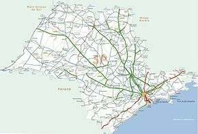
Map of the itinerary of Anchieta Highway (in red) | |
|
Rodovia Anchieta | |
| Route information | |
| Maintained by Ecovias | |
| Length: | 72 km (45 mi) |
| Existed: |
1947 (north lane) 1953 (south lane) – present |
| Major junctions | |
| North end: | Rua das Juntas Provisórias in São Paulo, SP |
|
| |
| South end: | Avenida Getúlio Dornelles Vargas in Santos, SP |
| Highway system | |
|
Highways in Brazil | |
Rodovia Anchieta (Anchieta Highway, official designation SP-150) is a highway connection between São Paulo and the Atlantic coast, the cities of Cubatão and Santos, in Brazil. In the plateau, the highway serves several cities of Greater São Paulo, such as São Bernardo do Campo, São Caetano do Sul, Santo André and Riacho Grande and traverses a picturesque region of dams and rain forests.
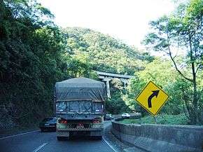
Rodovia Anchieta is a major pride of the Brazilian engineering, because it was built with a great number of bridges and tunnels along the steep cliffs of Serra do Mar; and the first modern, concrete-paved road built in São Paulo in the 1930s.
The highway is one of the busiest of the country, because of the movement of goods to and from Santos's seaport. Traffic problems are common, mainly if there is bad weather or in long weekends when many families living in São Paulo go to Santos or Guarujá beaches. Rodovia Anchieta is approximately 60 km long.
It is named after the Jesuit priest Father José de Anchieta, who often used the simple forest trek that connected to city of São Vicente by the sea with the village he helped to found in the high plateau, São Paulo dos Campos de Piratininga, in 1554.
The highway is managed by a state concession to the private company Ecovias, and therefore is a toll road.
The two carriageways of Rodovia Anchieta are both fully reversible. Traffic is managed to flow either bidirectionally (uphill on one carriageway and downhill on the other) or unidirectionally (uphill or downhill on both carriageways), depending on demand. In the unidirectional mode, the opposing traffic is diverted to Rodovia dos Imigrantes.
See also
| Rodovias | |
|---|---|
| Expressways |
|
| Surface streets |
|
Coordinates: 23°47′22″S 46°31′10″W / 23.78944°S 46.51944°W