Roslyakovo, Murmansk Oblast
| Roslyakovo (English) Росляково (Russian) | |
|---|---|
|
- Urban-type settlement[1] - (abolished) | |
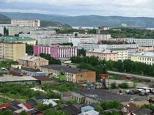 View of Roslyakovo | |
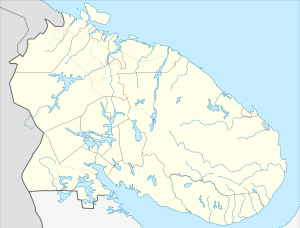
.svg.png) Location of Murmansk Oblast in Russia | |
 Roslyakovo | |
|
| |
_(1990).png) | |
|
| |
| Administrative status (as of December 2014) | |
| Country | Russia |
| Federal subject | Murmansk Oblast[1] |
| Administratively subordinated to | closed administrative-territorial formation of Severomorsk[1] |
| Municipal status (as of December 2014) | |
| Urban okrug | Severomorsk Urban Okrug[2] |
| Statistics | |
| Population (2010 Census) | 8,696 inhabitants[3] |
| Time zone | MSK (UTC+03:00)[4] |
| Founded | 1896[5] |
| Urban-type settlement status since | 1959[5] |
| Abolished | January 1, 2015[2] |
| Postal code(s)[6] | 184635 |
| Dialing code(s) | +7 81537 |
| Roslyakovo on Wikimedia Commons | |
Roslyakovo (Russian: Росляко́во) was a closed city with a population of about 8,000 located about 15 kilometers north of Murmansk.[7] Until January 1, 2015 it was an urban locality (an urban-type settlement) under the administrative jurisdiction of the closed-administrative territorial formation of Severomorsk in Murmansk Oblast, Russia, located on the Kola Peninsula on the Kola Bay, 6 kilometers (3.7 mi) west of Severomorsk proper.
It was abolished, with its territory merged into the city of Murmansk, on January 1, 2015.[2] Population: 8,696 (2010 Census);[3] 9,458 (2002 Census);[8] 11,981 (1989 Census).[9]
History
It was founded in 1896.[5] The colony of Roslyakovo was one of the twenty-one included into Alexandrovskaya Volost of Alexandrovsky Uyezd of Arkhangelsk Governorate upon its establishment on July 1, 1920.[10] Urban-type settlement status was granted to Roslyakovo in 1959.[5]
Roslyakovo was in jurisdiction of the closed administrative-territorial formation of Severomorsk until January 1, 2015,[1] when it was abolished, with its territory merged into the city of Murmansk.[2]
There is no restaurant or cafe in town. Formerly, there was a medical clinic. There are "a few 7-Eleven-sized grocery stores."[7] The Church of St. Michael the Archangel, founded in 1991, is the only church in the town.[11]
Most of the population are in the Russian navy, or work as navy contractors. Shipbuilding is a local industry. Rosneft, the state owned oil company, is opening facilities in the town.[7]
References
Notes
- 1 2 3 4 Decree #603
- 1 2 3 4 Law #1812-01-ZMO
- 1 2 Russian Federal State Statistics Service (2011). "Всероссийская перепись населения 2010 года. Том 1" [2010 All-Russian Population Census, vol. 1]. Всероссийская перепись населения 2010 года (2010 All-Russia Population Census) (in Russian). Federal State Statistics Service. Retrieved June 29, 2012.
- ↑ Правительство Российской Федерации. Федеральный закон №107-ФЗ от 3 июня 2011 г. «Об исчислении времени», в ред. Федерального закона №271-ФЗ от 03 июля 2016 г. «О внесении изменений в Федеральный закон "Об исчислении времени"». Вступил в силу по истечении шестидесяти дней после дня официального опубликования (6 августа 2011 г.). Опубликован: "Российская газета", №120, 6 июня 2011 г. (Government of the Russian Federation. Federal Law #107-FZ of June 31, 2011 On Calculating Time, as amended by the Federal Law #271-FZ of July 03, 2016 On Amending Federal Law "On Calculating Time". Effective as of after sixty days following the day of the official publication.).
- 1 2 3 4 Кольская энциклопедия. Росляково (Russian)
- ↑ Почта России. Информационно-вычислительный центр ОАСУ РПО. (Russian Post). Поиск объектов почтовой связи (Postal Objects Search) (Russian)
- 1 2 3 Kelly, Mary Louise (August 4, 2016). "A Once-Closed Russian Military Town In The Arctic Opens To The World". NPR. Retrieved August 4, 2016.
- ↑ Russian Federal State Statistics Service (May 21, 2004). "Численность населения России, субъектов Российской Федерации в составе федеральных округов, районов, городских поселений, сельских населённых пунктов – районных центров и сельских населённых пунктов с населением 3 тысячи и более человек" [Population of Russia, Its Federal Districts, Federal Subjects, Districts, Urban Localities, Rural Localities—Administrative Centers, and Rural Localities with Population of Over 3,000] (XLS). Всероссийская перепись населения 2002 года [All-Russia Population Census of 2002] (in Russian). Retrieved August 9, 2014.
- ↑ Demoscope Weekly (1989). "Всесоюзная перепись населения 1989 г. Численность наличного населения союзных и автономных республик, автономных областей и округов, краёв, областей, районов, городских поселений и сёл-райцентров" [All Union Population Census of 1989: Present Population of Union and Autonomous Republics, Autonomous Oblasts and Okrugs, Krais, Oblasts, Districts, Urban Settlements, and Villages Serving as District Administrative Centers]. Всесоюзная перепись населения 1989 года [All-Union Population Census of 1989] (in Russian). Институт демографии Национального исследовательского университета: Высшая школа экономики [Institute of Demography at the National Research University: Higher School of Economics]. Retrieved August 9, 2014.
- ↑ Administrative-Territorial Division of Murmansk Oblast, p. 66
- ↑ "Roslyakovo. Church of St. Michael the Archangel.". Cobori.ru. Retrieved August 4, 2016.
Sources
- Official website of Murmansk Oblast. Registry of the Administrative-Territorial Structure of Murmansk Oblast (Russian)
- Архивный отдел Администрации Мурманской области. Государственный Архив Мурманской области. (1995). Административно-территориальное деление Мурманской области (1920-1993 гг.). Справочник. Мурманск: Мурманское издательско-полиграфическое предприятие "Север".
- Мурманская областная Дума. Закон №1812-01-ЗМО от 19 декабря 2014 г. «Об упразднении населённого пункта Мурманской области и о внесении изменений в отдельные законодательные акты Мурманской области». Вступил в силу 1 января 2015 г. Опубликован: "Мурманский Вестник", №246–247, с. 56, 25 декабря 2014 г. (Murmansk Oblast Duma. Law #1812-01-ZMO of December 19, 2014 On Abolishing an Inhabited Locality in Murmansk Oblast and on Amending Various Legislative Acts of Murmansk Oblast. Effective as of January 1, 2015.).
- Президент Российской Федерации. Указ №603 от 1 сентября 2014 г. «О преобразовании закрытого административно-территориального образования — города Североморска Мурманской области». Вступил в силу со дня подписания. Опубликован: Официальный интернет-портал правовой информации http://www.pravo.gov.ru, 2 сентября 2014 г. (President of the Russian Federation. Decree #603 of September 1, 2014 On the Transformation of the Closed Administrative-Territorial Formation—the Town of Severomorsk in Murmansk Oblast. Effective as of the date of signing.).