Round Hill Village, Nevada
| Round Hill Village, Nevada | |
|---|---|
| Census-designated place | |
 Round Hill Village Location of Round Hill Village, Nevada | |
| Coordinates: 38°59′2″N 119°56′33″W / 38.98389°N 119.94250°WCoordinates: 38°59′2″N 119°56′33″W / 38.98389°N 119.94250°W | |
| Country | United States |
| State | Nevada |
| Area | |
| • Total | 5.9 sq mi (15.3 km2) |
| • Land | 5.8 sq mi (15.0 km2) |
| • Water | 0.1 sq mi (0.3 km2) |
| Elevation | 6,304 ft (1,921 m) |
| Population (2010) | |
| • Total | 759 |
| • Density | 131/sq mi (50.6/km2) |
| Time zone | Pacific (PST) (UTC-8) |
| • Summer (DST) | PDT (UTC-7) |
| Area code(s) | 775 |
| FIPS code | 32-62170 |
Round Hill Village is a census-designated place (CDP) in Douglas County, Nevada, United States. The population was 759 at the 2010 census.[1] Prior to 2010, the community was part of the Zephyr Cove–Round Hill Village CDP.
Geography
Round Hill Village is located on the east shore of Lake Tahoe in far western Nevada. U.S. Route 50 is the main road through the CDP, leading south 2 miles (3 km) to the California state line and northeast 23 miles (37 km) to Carson City. Zephyr Cove is immediately to the north, and Stateline is to the south. Kingsbury occupies the ridge to the east.
According to the United States Census Bureau, the Round Hill Village CDP has a total area of 5.9 square miles (15.3 km2), of which 5.8 square miles (15.0 km2) is land and 0.12 square miles (0.3 km2), or 2.19%, is water.[1]
References
- 1 2 "Geographic Identifiers: 2010 Demographic Profile Data (G001): Round Hill Village CDP, Nevada". U.S. Census Bureau, American Factfinder. Retrieved January 24, 2013.
Municipalities and communities of Douglas County, Nevada, United States | ||
|---|---|---|
| CDPs | 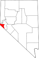 | |
| Unincorporated communities | ||