Missouri Route 18
| ||||
|---|---|---|---|---|
| Route information | ||||
| Maintained by MoDOT | ||||
| Length: | 55.88 mi (89.93 km) | |||
| Major junctions | ||||
| West end: | 359th Street / State Line Road, Kansas state line | |||
| East end: |
| |||
| Highway system | ||||
| ||||

Route 18 is a highway in western Missouri. Its eastern terminus is at the intersection of Route 13/Route 52 and Route 7 in Clinton. Its western terminus is at the Kansas state line near Drexel. It continues into Kansas as a county road.
Route description
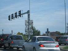
Route 18's eastern terminus at Route 7/13/52 in Clinton.
Route 18 begins at the Kansas state line just west of Drexel. It runs for three miles (5 km) along the Cass/Bates County line. Route 18 then turns south to Merwin, where it turns back east. It then runs through Adrian, Missouri, before having a diamond interchange with the Interstate 49/U.S. Route 71 freeway.[1] Route 18 then runs south of Altona and through Ballard. It then runs through Clinton. Route 18 then ends at Routes 7, 13, and 52.
Major intersections
| County | Location | mi[2] | km | Destinations | Notes |
|---|---|---|---|---|---|
| Bates | Drexel | 0.00 | 0.00 | 359th Street / State Line Road | Western terminus; Kansas state line |
| Adrian | 20.84 | 33.54 | Diamond interchange[1] | ||
| Henry | Clinton | 54.69 | 88.02 | ||
| 55.88 | 89.93 | Eastern terminus | |||
| 1.000 mi = 1.609 km; 1.000 km = 0.621 mi | |||||
References
- 1 2 Google Maps (Map). Cartography by NAVTEQ. Google, Inc.
- ↑ DeLorme Street Atlas USA 2007, Toggle Measure Tool
This article is issued from Wikipedia - version of the 11/9/2016. The text is available under the Creative Commons Attribution/Share Alike but additional terms may apply for the media files.