Clinton, Missouri
| Clinton, Missouri | |
|---|---|
| City | |
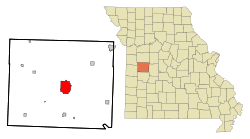 Location of Clinton, Missouri | |
| Coordinates: 38°22′12″N 93°46′18″W / 38.37000°N 93.77167°WCoordinates: 38°22′12″N 93°46′18″W / 38.37000°N 93.77167°W | |
| Country | United States |
| State | Missouri |
| County | Henry |
| Area[1] | |
| • Total | 9.26 sq mi (23.98 km2) |
| • Land | 9.14 sq mi (23.67 km2) |
| • Water | 0.12 sq mi (0.31 km2) |
| Elevation | 804 ft (245 m) |
| Population (2010)[2] | |
| • Total | 9,008 |
| • Estimate (2012[3]) | 9,043 |
| • Density | 985.6/sq mi (380.5/km2) |
| Time zone | Central (CST) (UTC-6) |
| • Summer (DST) | CDT (UTC-5) |
| ZIP code | 64735 |
| Area code(s) | 660 |
| FIPS code | 29-14986[4] |
| GNIS feature ID | 0715997[5] |
| Website | Official website |
Clinton is a city in Henry County, Missouri, United States. The population was 9,008 at the 2010 census. It is the county seat of Henry County.[6]
History
Clinton was laid out in 1836.[7] The city was named for New York Governor DeWitt Clinton, a key promoter of the Erie Canal.[8][9] A post office called Clinton has been in operation since 1850.[10]
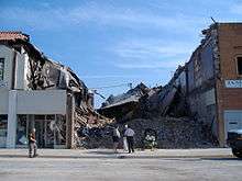
On June 26, 2006, a building in the historic town square collapsed; on the second and third floors, an Elks Lodge (Benevolent and Protective Order of Elks) meeting was taking place. The leader, Tony Komer, who was on the third floor of the building preparing a speech, is the only one who died. Nine people were pulled from the rubble, while the rest left on their own power.[11] In the "Olde Glory Days" parade, which occurred less than one week after the accident, Komer was memorialized, and Elk's Lodge members from many parts of Western Missouri marched to show their support for the Clinton Lodge.
Geography
Clinton is located at 38°22′12″N 93°46′18″W / 38.37000°N 93.77167°W (38.370067, -93.771689).[12] According to the United States Census Bureau, the city has a total area of 9.26 square miles (23.98 km2), of which, 9.14 square miles (23.67 km2) is land and 0.12 square miles (0.31 km2) is water.[1]
The downtown square serves as a center for community commerce and public affairs (The square also serves as a parking lot.) It features a central courthouse and numerous shops, stores, and eating facilities. More than a dozen churches are found in the community, a few of which predate 1900. Several important state highways intersect at Clinton, and a cluster of "big-box" stores, as well as several "national-chain" motels, are located in that area. Smaller motels are found on the outskirts of town on all sides. The several residential neighborhoods range from directly adjacent to the town square to lying a mile or more away. In terms of wealth, the neighborhoods go from solidly lower income, to middle-class ranch-house areas to a small, affluent borough, where larger lawns and brick-and-Tudor homes predominate.
Demographics
| Historical population | |||
|---|---|---|---|
| Census | Pop. | %± | |
| 1870 | 610 | — | |
| 1880 | 2,868 | 370.2% | |
| 1890 | 4,737 | 65.2% | |
| 1900 | 5,061 | 6.8% | |
| 1910 | 4,992 | −1.4% | |
| 1920 | 5,098 | 2.1% | |
| 1930 | 5,744 | 12.7% | |
| 1940 | 6,041 | 5.2% | |
| 1950 | 6,075 | 0.6% | |
| 1960 | 6,925 | 14.0% | |
| 1970 | 7,504 | 8.4% | |
| 1980 | 8,366 | 11.5% | |
| 1990 | 8,703 | 4.0% | |
| 2000 | 9,311 | 7.0% | |
| 2010 | 9,008 | −3.3% | |
| Est. 2015 | 8,899 | [13] | −1.2% |
2010 census
As of the census[2] of 2010, there were 9,008 people, 3,935 households, and 2,371 families residing in the city. The population density was 985.6 inhabitants per square mile (380.5/km2). There were 4,454 housing units at an average density of 487.3 per square mile (188.1/km2). The racial makeup of the city was 95.1% White, 1.9% African American, 0.4% Native American, 0.3% Asian, 0.5% from other races, and 1.8% from two or more races. Hispanic or Latino of any race were 2.0% of the population.
There were 3,935 households of which 27.9% had children under the age of 18 living with them, 42.2% were married couples living together, 13.3% had a female householder with no husband present, 4.8% had a male householder with no wife present, and 39.7% were non-families. 34.5% of all households were made up of individuals and 16.1% had someone living alone who was 65 years of age or older. The average household size was 2.24 and the average family size was 2.82.
The median age in the city was 40.6 years. 22.6% of residents were under the age of 18; 8.5% were between the ages of 18 and 24; 23.4% were from 25 to 44; 25.1% were from 45 to 64; and 20.5% were 65 years of age or older. The gender makeup of the city was 46.9% male and 53.1% female.
2000 census
As of the census[4] of 2000, there were 9,311 people, 3,978 households, and 2,502 families residing in the city. The population density was 1,007.6 people per square mile (389.1/km²). There were 4,342 housing units at an average density of 469.9 per square mile (181.4/km²). The racial makeup of the city was 95.49% White, 1.77% African American, 0.92% Native American, 0.31% Asian, 0.50% from other races, and 1.00% from two or more races. Hispanic or Latino of any race were 1.03% of the population.
There were 3,978 households out of which 27.8% had children under the age of 18 living with them, 47.0% were married couples living together, 12.1% had a female householder with no husband present, and 37.1% were non-families. 33.1% of all households were made up of individuals and 16.3% had someone living alone who was 65 years of age or older. The average household size was 2.26 and the average family size was 2.84.
In the city the population was spread out with 23.4% under the age of 18, 8.8% from 18 to 24, 25.6% from 25 to 44, 21.2% from 45 to 64, and 20.9% who were 65 years of age or older. The median age was 39 years. For every 100 females there were 88.4 males. For every 100 females age 18 and over, there were 82.7 males.
The median income for a household in the city was $28,079, and the median income for a family was $32,378. Males had a median income of $26,834 versus $19,096 for females. The per capita income for the city was $16,282. About 11.9% of families and 15.5% of the population were below the poverty line, including 21.0% of those under age 18 and 13.3% of those age 65 or over.
Recreation
Clinton lies at the western end of the Katy Trail, a 225-mile long state park used by cyclists, runners, and horseback riders. The rail trail is built on the path of the old Missouri-Kansas-Texas Railroad, which was abandoned between Clinton and Sedalia in 1989. The former Katy railroad from Clinton south to Nevada (MO) is still in operation by the Missouri and Northern Arkansas Railroad (RailAmerica). The city is also situated near Truman Lake which is widely known for its excellent boating, fishing, camping, and other related activities. Clinton is also home to two of the area's finer 18-hole golf courses.
2007 Tour of Missouri
September 12, 2007, the Tour of Missouri bicycle race began stage 2 from Clinton, Mo. The initial take off began from the historic downtown square, and ended in Springfield, Mo.
Notable people
- Virgil Hill, Olympic boxing silver medalist, member of International Boxing Hall of Fame
- Nick Petree, Minor League baseball player
- Delbert Lee Scott, politician, college president
- David Steward, World Wide Technology founder, chairman
See also
References
- 1 2 "US Gazetteer files 2010". United States Census Bureau. Archived from the original on 2012-06-26. Retrieved 2012-07-08.
- 1 2 "American FactFinder". United States Census Bureau. Retrieved 2012-07-08.
- ↑ "Population Estimates". United States Census Bureau. Archived from the original on 2013-06-17. Retrieved 2013-05-30.
- 1 2 "American FactFinder". United States Census Bureau. Archived from the original on 2013-09-11. Retrieved 2008-01-31.
- ↑ "US Board on Geographic Names". United States Geological Survey. 2007-10-25. Retrieved 2008-01-31.
- ↑ "Find a County". National Association of Counties. Archived from the original on 2011-05-31. Retrieved 2011-06-07.
- ↑ "Henry County Place Names, 1928–1945 (archived)". The State Historical Society of Missouri. Archived from the original on 24 June 2016. Retrieved 4 October 2016.
- ↑ "Profile for Clinton, Missouri". ePodunk. Retrieved 2010-04-26.
- ↑ Gannett, Henry (1905). The Origin of Certain Place Names in the United States. Govt. Print. Off. p. 105.
- ↑ "Post Offices". Jim Forte Postal History. Archived from the original on 5 October 2016. Retrieved 4 October 2016.
- ↑ Elks building collapses, killing group’s leader
- ↑ "US Gazetteer files: 2010, 2000, and 1990". United States Census Bureau. 2011-02-12. Retrieved 2011-04-23.
- ↑ "Annual Estimates of the Resident Population for Incorporated Places: April 1, 2010 to July 1, 2015". Retrieved July 2, 2016.
- ↑ "Census of Population and Housing". Census.gov. Archived from the original on May 11, 2015. Retrieved June 4, 2015.
External links
| Wikisource has the text of a 1911 Encyclopædia Britannica article about Clinton, Missouri. |
- Official website
- Historic maps of Clinton in the Sanborn Maps of Missouri Collection at the University of Missouri
Municipalities and communities of Henry County, Missouri, United States | ||
|---|---|---|
| Cities | 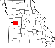 | |
| Villages | ||
| Townships | ||
| CDP | ||
| Other unincorporated communities | ||
| Ghost town | ||
| Footnotes | ‡This populated place also has portions in an adjacent county or counties | |