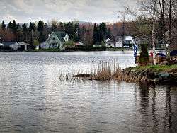
Roxton Pond, Quebec
| Roxton Pond | |
|---|---|
| Municipality | |
 | |
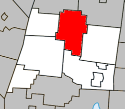 Location within La Haute-Yamaska RCM | |
 Roxton Pond Location in southern Quebec | |
| Coordinates: 45°29′N 72°40′W / 45.483°N 72.667°WCoordinates: 45°29′N 72°40′W / 45.483°N 72.667°W[1] | |
| Country |
|
| Province |
|
| Region | Montérégie |
| RCM | La Haute-Yamaska |
| Constituted | December 17, 1997 |
| Government[2][3] | |
| • Mayor | Raymond Loignon |
| • Federal riding | Shefford |
| • Prov. riding | Johnson |
| Area[2][4] | |
| • Total | 103.40 km2 (39.92 sq mi) |
| • Land | 97.68 km2 (37.71 sq mi) |
| Population (2011)[4] | |
| • Total | 3,786 |
| • Density | 38.8/km2 (100/sq mi) |
| • Pop 2006-2011 |
|
| • Dwellings | 1,561 |
| Time zone | EST (UTC−5) |
| • Summer (DST) | EDT (UTC−4) |
| Postal code(s) | J0E 1Z0 |
| Area code(s) | 450 and 579 |
| Highways |
|
| Website |
www |
Roxton Pond is a municipality in the Canadian province of Quebec, located within La Haute-Yamaska Regional County Municipality. The population as of the Canada 2011 Census was 3,786. The municipality was created in 1997 with the merger of the Parish and the Village of Roxton Pond.
Demographics
Population
Population trend:[5]
| Census | Population | Change (%) |
|---|---|---|
| 2011 | 3,786 | |
| 2006 | 3,599 | |
| 2001 | 3,527 | |
| Merger | 3,348 (+) | |
| 1996 | 2,357 | |
| 1991 | 2,116 | N/A |
(+) Amalgamation of the Parish and the Village of Roxton Pond on December 17, 1997.
Language
Mother tongue language (2006)[6]
| Language | Population | Pct (%) |
|---|---|---|
| French only | 3,455 | 96.37% |
| English only | 40 | 1.12% |
| Both English and French | 10 | 0.28% |
| Other languages | 80 | 2.23% |
See also
References
- ↑ Reference number 341093 of the Commission de toponymie du Québec (French)
- 1 2 Ministère des Affaires municipales, des Régions et de l'Occupation du territoire: Roxton Pond
- ↑ Parliament of Canada Federal Riding History: SHEFFORD (Quebec)
- 1 2 2011 Statistics Canada Census Profile: Roxton Pond, Quebec
- ↑ Statistics Canada: 1996, 2001, 2006, 2011 census
- ↑ 2006 Statistics Canada Community Profile: Roxton Pond, Quebec
External links
 Media related to Roxton Pond at Wikimedia Commons
 |
Saint-Valérien-de-Milton | Roxton | | |
| Sainte-Cécile-de-Milton | |
Saint-Joachim-de-Shefford | ||
| ||||
| | ||||
| Granby | Shefford |
| Cities | |
|---|---|
| Municipalities | |
| Townships | |
| Villages | |
| |
This article is issued from Wikipedia - version of the 11/2/2016. The text is available under the Creative Commons Attribution/Share Alike but additional terms may apply for the media files.