Rozdziele, Bochnia County
| Rozdziele | |
|---|---|
| Village | |
|
Church | |
 Rozdziele | |
| Coordinates: 49°48′N 20°27′E / 49.800°N 20.450°E | |
| Country |
|
| Voivodeship | Lesser Poland |
| County | Bochnia |
| Gmina | Żegocina |
| Population [1] | 850 |
| Website | www.zegocina.pl (Polish) |
Rozdziele [rɔzˈd͡ʑɛlɛ] is a village and sołectwo in the administrative district of Gmina Żegocina, within Bochnia County, Lesser Poland Voivodeship, in southern Poland.[2] It lies on road number 965, roughly 3 km (2 mi) south of Żegocina and 25 km (16 mi) south of the county town of Bochnia, and about 10 km (6 mi) north of Limanowa.
Origins
The name Rozdziele indicates the idea of division and relates to the area being on the drainage divide between the Raba and Dunajec rivers. The earliest mention of the name occurs in 1262, in a grant of forest rights from king Bolesław V the Chaste, though there is no indication as to whether a settlement with that name existed then. The first definite mention of Rozdziele as a village does not occur until 1490.[3]
The centre of the village is in Upper Rozdziele (Rozdziele Górne); Lower Rozdziele (Rozdziele Dolne) lies downhill towards the east.
Economy
These days the local economy centres around agriculture and, increasingly, tourism, given the village's location amongst hills and unspoilt countryside.[3]
Religion
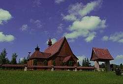
There is a historic Roman Catholic church by the lane leading to Lower Rozdziele. Dedicated to St. James the Apostle it is subsidiary to the parish church in Żegocina. Of wooden construction, typical of this part of Poland, the building dates back to the 16th century, and originally stood in Królówka. It was transported to its current location in 1986.[4][5][6] The building is on the Wooden Architecture Trail.[7]
References
- ↑ "Jednostki pomocnicze gminy Żegocina - Sołectwa" [Auxiliary Units of Gmina Żegocina - Sołectwos] (in Polish). Retrieved 3 September 2009.
- ↑ "Central Statistical Office (GUS) – TERYT (National Register of Territorial Land Apportionment Journal)" (in Polish). 1 June 2008.
- 1 2 "Gmina Żegocina - sołectwo Rozdziele" (in Polish). 2003. Retrieved 3 September 2009.
- ↑ "Kościół w Rozdzielu - historia" [The Church in Rozdziele - its History] (in Polish). Retrieved 4 September 2009.
- ↑ "Zabytkowy Kościół w Rozdzielu, Polska" [The Historic Church in Rozdziele] (in Polish). Retrieved 4 September 2009.
- ↑ "Gmina Żegocina - Zabytkowy Kościół w Rozdzielu" [The Historic Church in Rozdziele] (in Polish). Retrieved 4 September 2009.
- ↑ "The Wooden Architecture Route in Lesser Poland". Retrieved 4 September 2009.
See also
| Seat |  | |
|---|---|---|
| Other villages | ||
Coordinates: 49°48′00″N 20°27′00″E / 49.8000°N 20.4500°E