Rural Municipality of East St. Paul
| Rural Municipality of East St. Paul | |
|---|---|
 Rural Municipality of East St. Paul East St. Paul in Manitoba | |
| Coordinates: 49°58′38″N 97°00′37″W / 49.97722°N 97.01028°WCoordinates: 49°58′38″N 97°00′37″W / 49.97722°N 97.01028°W | |
| Incorporation | October 23, 1915 |
| Area | |
| • Land | 42.10 km2 (16.25 sq mi) |
| Population (2011)[1] | |
| • Total | 9,046 |
| • Density | 214.9/km2 (557/sq mi) |
| Time zone | CST (UTC-6) |
| • Summer (DST) | CDT (UTC-5) |
| Website | http://www.eaststpaul.com/ |
East St. Paul is a rural municipality in Manitoba, Canada. It is located north-east of and adjacent to the city of Winnipeg, and is part of the Winnipeg Metropolitan Area. The municipality was formed on 3 November 1915 when the municipality of St. Paul (1888-1914) was subdivided into West St. Paul and East St. Paul,[2] with the Red River acting as the dividing line. It encompasses 41 square kilometres (16 sq mi).
Geography
| Historical population | ||
|---|---|---|
| Year | Pop. | ±% |
| 1981 | 3,596 | — |
| 1986 | 4,385 | +21.9% |
| 1996 | 6,437 | +46.8% |
| 2001 | 7,677 | +19.3% |
| 2006 | 8,733 | +13.8% |
| 2011 | 9,046 | +3.6% |
East St. Paul includes the communities of Birds Hill, North Hill, Glengarry, River East Estates, Whidbey Harbour, Pritchard Farm Estates, and Silverfox Estates. Historic Henderson Highway follows the Red River through East St. Paul areas settled by the Red River Settlers. The Red River Floodway diverts part of the Red River's flow around the city of Winnipeg and through East St. Paul and discharges it back into the Red River North of the dam in Lockport. The Trans Canada Trail and the Duff Roblin Parkway Trail also pass through East St. Paul.
East St. Paul has a gated community for seniors and new home development is underway at Countryside Crossing, By The Park, Prairie Ridge, Southlands Drive and Village Centre. East St. Paul contains greenhouses and numerous small farms, primarily of the market gardening variety, as well as natural forest, creek and pond areas.
The population growth of East St. Paul has slowed significantly in recent years.[1] Like other surrounding communities, the municipality has historically attracted people from Winnipeg and elsewhere due to its close proximity to Winnipeg, the larger properties, lower rates of property tax,[3] and semi-rural atmosphere.
History
In 1880, the Rural Municipality of St. Paul was established, with offices located on the west side of the Red.[4] The Red River was a barrier that made doing business an inconvenience, as those on the east side had to travel over water to the west side.[5] There were no bridges in the vicinity; the closest being Winnipeg's Redwood Bridge about nine kilometers to the south. The population was growing: as more families arrived to settle in the area, community spirit grew. On the east side of the river, schools and businesses were started. The community became diversified with industry ranging from market gardening to general stores. On November 3, 1915 the RMs of East St. Paul and West St. Paul officially received royal ascent. The first meeting of the RM of East St. Paul took place on January 4, 1916 in a room in secretary-treasurer Walter Gorham’s house at 2051 Roseneath Avenue.[5] In 1951, a one-story building was erected at 2127 Birds Hill Road. In 1980, the current municipal office complex was built at 3021 Birds Hill Road.[5]
Recreation
East St. Paul has a recreation centre, which offers curling and ice hockey programs, and an outdoor recreation complex for soccer and baseball. An 18 hole golf course (The Meadows) and tennis courts are used by residents and nonresidents in the summer, as well as a toboggan hill and an outdoor skating on a frozen lake in the winter. In addition to the Trans Canada Trail and the Duff Roblin Parkway Trail, the municipality also contains several other walking trails and pathways, like the Bottomly Creek Trail and the Pritchard Farm Trails.
A habitat rehabilitation project at Birds Hill, Manitoba transformed a depleted gravel pit into Silver Springs Park, with trails, a lake, and homes built along part of its perimeter. The pit dates to the late 19th century, when the Canadian Pacific Railway needed gravel ballast for its rail lines. The deposit was later worked to serve Winnipeg's needs for aggregate. Over the years, more than 20 million tonnes of gravel were removed from the site. The depleted quarry was graded and landscaped with native grasses and more than 1,200 trees and shrubs.[6] Geese, ducks, terns, gulls, American white pelicans, songbirds, foxes, rabbits, western painted turtles, muskrats and deer are frequently observed.
Policing
East St. Paul made national news in 2005 with the poor handling by East St.Paul Police and subsequent inquiry into death of Crystal Taman by an off duty Winnipeg police officer Derek Harvey-Zenk.[7][8][9][10][11][12] It was believed that the police officer was driving drunk when his truck rear-ended Taman, who was stopped at a red light. The East St. Paul police officers at the scene knew the offender, did not gather adequate evidence, and the prosecutor was forced to plea bargain a relatively light sentence. As a result of the evidence presented at the Taman Inquiry, the province disbanded the East St. Paul police force, replacing them with Royal Canadian Mounted Police officers.
This change from a local police force to RCMP resulted in several changes, most notable is the cost of policing. Prior to the changeover, the RM of East St. Paul paid for its local police force; however since the change to RCMP in January 2009, the costs of policing has been paid for by the provincial and federal governments.[13] The RCMP police detachment remains in the original location as the East St. Paul police force [13]
Gallery
-
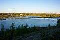
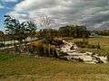
Silverfox Estates at lake of Silver Springs Park in Birds Hill, East St. Paul.
-
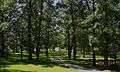
Pathway connecting Chase Drive with Birchwood Crescent, North Hill, East St. Paul.
-
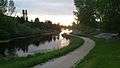
Eagle Creek at Pritchard Farm Properties, East St Paul, Manitoba
-
Streetscaping along Mowat Road in Southlands, East St. Paul. Manitoba
Neighbouring communities
 |
R.M. of St. Clements | | ||
| R.M. of West St. Paul | |
R.M. of Springfield | ||
| ||||
| | ||||
| City of Winnipeg |
References
- 1 2 "July 1, 2006 est".
- ↑ "Manitoba Municipalities: St. Paul". Manitoba Historical Society: Historic Places in Manitoba. Manitoba Historical Society. Retrieved 16 October 2015.
- ↑ Batra, Adrienne (2002). "Survey Says... East St. Paul". CANADIAN TAXPAYERS FEDERATION. Retrieved 22 June 2016.
According to the 2002 Capital Region Residential Property Taxes and Utility Charges Survey
- ↑ Redekop, Bill (11 June 2016). "A tale of two St. Pauls". www.winnipegfreepress.com. Winnipeg Free Press. Retrieved 22 June 2016.
- 1 2 3 Wenger, Lorna (2016). East St. Paul Centennial 1916 - 2016: A collection of history, stories, and community spirit. RM of East St. Paul.
- ↑ Plaque at Silver Springs Park
- ↑ "East St. Paul police, residents surprised by move to disband force". CBC. Canadian Press. October 7, 2008. Retrieved 16 October 2015.
- ↑ "East St. Paul police, residents surprised by move to disband force". CBC. CBC news. October 7, 2008. Retrieved 17 October 2015.
- ↑ "Report questions East St. Paul's handling of investigations". CBC. CBC news. June 30, 2006.
- ↑ "No conspiracy to protect officer involved in fatal crash, inquiry told". CBC News. 2008-07-07. Retrieved 2008-08-21.
- ↑ http://www.tamaninquiry.ca/
- ↑ http://news.gov.mb.ca/news/index.html?item=4565
- 1 2 "Policing Transition: Information for Residents of East St. Paul" (PDF). RCMP and Government of Manitoba. Retrieved 30 June 2016.
- Parks and Recreation Tour Map for the RM of East St. Paul
- Government of Manitoba project fact sheet