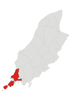
Rushen
| Parish of Rushen | |||||||||||||||
|---|---|---|---|---|---|---|---|---|---|---|---|---|---|---|---|
 | |||||||||||||||
| Details | |||||||||||||||
| |||||||||||||||
| Main Peaks | |||||||||||||||
| |||||||||||||||
| Treens | |||||||||||||||
| |||||||||||||||
Rushen (Manx: Rosien), formerly Kirk Christ Rushen (Manx: Skyll Creest Rosien), is a parish in the sheading of the same name in the Isle of Man. The parish is a fishing and agricultural district at the south-westernmost point of the island. The parish is one of three in the sheading of Rushen. The other two are Arbory and Malew.
Geography
Rushen parish includes the south-western extremity of the island, together with the Calf of Man along its rocky outcrops Kitterland and Chicken Rock, and contains an area of about 10 square miles (26 km2). It stretches round the coast from Strandhall (on the coast about halfway between Castletown and Port St Mary to the precipices west of Cronk ny Irrey Lhaa (Hill of the Day Watch, also spelled Arrey), known as the Stacks, or the Slogh, a distance of 16 miles (26 km). The principal headlands are Port St Mary Point, Black Head, Spanish Head (350 feet (110 m)), and Bradda Head (766 feet (233 m)); and the chief inlets are Port St Mary Bay, Perwick Bay, Bay Stacka, Port Erin Bay, and Fleshwick Bay.
The west of the parish is hilly, stretching from Cronk ny Irrey Lhaa (437 metres (1,434 ft), the highest point in the parish) along the western coast to Lhiattee ny Beinnee, Bradda Hill, Mull Hill, and the Sound, across which the ridge is continued on the Calf.
Port St Mary and Port Erin are the only significant settlements in the area and, while they are part of the parish for the purposes of the Anglican church, they are considered separate for local government purposes, as they each have their own village commissioners. Cregneash is a small village and folk museum near Mull Hill.[1]
Demographics
The Isle of Man census 2006 lists the population of the parish (excluding Port St Mary and Port Erin) as 1,591, a slight increase from the population of 1,504 in 2001.[2]
Governance
The local authority is Rushen Parish Commissioners who meet at Ballafesson Hall.[3]
References
- ↑ "Rushen Parish". isleofman.com. Retrieved 2008-10-14.
- ↑ "Isle of Man Census 2006 Summary Results" (PDF). Economic Affairs Division, Isle of Man Treasury. 2006. p. 3. Retrieved 2008-10-01.
- ↑ "Malew Parish - News". Malew Parish Commissioners. Retrieved 2008-10-14.
External links
- Manxnotebook - Rushen with full description of the parish
- Isle of Man Building Control Districts showing parish boundaries
- Great.Outdoors.com/ManxGlens Glenology - Manx Glens An ongoing study of Manx glens, their locations and meanings.
- Rushen Parish Commissioners
- GeoHive Census Information
External links
Coordinates: 54°05′05″N 4°44′51″W / 54.08472°N 4.74750°W