Dalby, Isle of Man
| Dalby | |
| Manx: Delbee | |
 Dalby |
|
| OS grid reference | SC2179 |
|---|---|
| Parish | Patrick |
| Sheading | Glenfaba |
| Crown dependency | Isle of Man |
| Post town | ISLE OF MAN |
| Postcode district | IM5 |
| Dialling code | 01624 |
| Police | Isle of Man |
| Fire | Isle of Man |
| Ambulance | Isle of Man |
| House of Keys | Glenfaba |
|
|
Coordinates: 54°10′00″N 4°44′00″W / 54.16667°N 4.73333°W
Dalby is a small hamlet on the Isle of Man, located near the western coast. It lies on the A27 Port Erin to Peel road, five miles south of Peel.
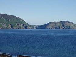
The hamlet looks out towards the Irish Sea from the western side of Dalby Mountain. The Raad ny Foillan long distance coastal footpath runs through Dalby.
Prior to its closure in 2007,[1] the hamlet had a public house called the Ballacallin Hotel which was known for its views of the sunset over Niarbyl. Niarbyl is home to a cafe and visitor center, as well as some traditional Manx cottages. It can be accessed by car, with parking available at the cafe.
During World War II, a radar station was located at Dalby. The radar station consisted of a number of bunkers, still visible in the fields between Dalby and Niarbyl and now part of local farm land.[2]
Religion
St James church is a Church of England church in the Diocese of Sodor and Man. The church was one of several commissioned by the Bishop of Sodor and Man, Bishop Ward and was consecrated in 1839. It incorporates classrooms which are now used as the church hall.[3]
References
- ↑ "Dalby residents' meeting over Ballacallin Hotel site". Isle of Man Newspapers. 2008-09-11. Retrieved 2009-07-03.
- ↑ "Isle of Man Radar Stations". Subterranea Britannica. 2003. Retrieved 2009-07-03.
- ↑ "Parish of Patrick churches". isleofman.com. 2006. Retrieved 2008-10-05.