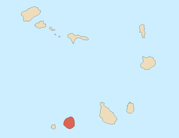
São Lourenço (São Filipe)
| São Lourenço | |
|---|---|
| Civil parish | |
 São Lourenço | |
| Coordinates: 14°59′N 24°26′W / 14.98°N 24.44°WCoordinates: 14°59′N 24°26′W / 14.98°N 24.44°W | |
| Country | Cape Verde |
| Island | Fogo |
| Municipality | São Filipe |
| Area | |
| • Total | 96 km2 (37 sq mi) |
| Population (2010)[1] | |
| • Total | 8,899 |
| • Density | 93/km2 (240/sq mi) |
São Lourenço is a freguesia (civil parish) of Cape Verde. It covers the northern part of the municipality of São Filipe, on the island of Fogo.
Settlements
The freguesia consists of the following settlements, its population data was of the 2010 census:
- Achada Mentirosa (pop: 344)
- As Hortas (pop: 380)
- Campanas Baixo (pop: 783)
- Campanas Cima (pop: 375)
- Chã de Monte (pop: 118)
- Curral Grande (pop: 398)
- Galinheiro (pop: 877)
- Inhuco (pop: 517)
- Lomba (pop: 731)
- Monte Tabor (pop: 170)
- Pedro Homem (pop: 315)
- Pico Gomes (pop: 118)
- Ponta Verde (pop: 1,072)
- Ribeira Filipe (pop: 548)
- Santo António (pop: 530)
- São Domingos (pop: 315)
- São Jorge (pop: 635)
- Velho Manuel (pop: 604)
Sports
The football/soccer club União de São Lourenço is the sports team of the parish, it is based in the parish seat of Curral Grande.
References
- ↑ "2010 Census results". Instituto Nacional de Estatística Cabo Verde (in Portuguese). 17 March 2014.
The Island of Fogo | ||
|---|---|---|
| Towns, villages and settlements |
|  |
| Municipalities | ||
| Parishes | ||
| Mountains | ||
| Other geographical features | ||
| Transportation |
| |
This article is issued from Wikipedia - version of the 11/11/2016. The text is available under the Creative Commons Attribution/Share Alike but additional terms may apply for the media files.