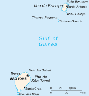
São Tomé Island
| Native name: <span class="nickname" ">Ilha de São Tomé | |
|---|---|
 Map of São Tomé and Príncipe | |
.jpg) | |
| Geography | |
| Location | Gulf of Guinea |
| Coordinates | 0°14′N 6°36′E / 0.233°N 6.600°E |
| Archipelago | Bight of Bonny |
| Area | 854 km2 (330 sq mi) |
| Length | 48 km (29.8 mi) |
| Width | 32 km (19.9 mi) |
| Highest elevation | 2,024 m (6,640 ft) |
| Highest point | Pico de São Tomé |
| Administration | |
|
São Tomé and Príncipe | |
| Province | São Tomé Province |
| Largest settlement | São Tomé (pop. 56,166) |
| Demographics | |
| Population | 157,000 (2009) |
| Pop. density | 183.84 /km2 (476.14 /sq mi) |
| Ethnic groups | Mestico, angolares (descendants of Angolan slaves), forros (descendants of freed slaves), servicais (contract laborers from Angola, Mozambique, and Cape Verde), tongas (children of servicais born on the islands), Europeans (primarily Portuguese) |

São Tomé Island, at 854 km2 (330 sq mi), is the largest island of São Tomé and Príncipe and is home to about 157,000 or 96% of the nation's population. This island and smaller nearby islets make up São Tomé Province, which is divided into six districts. The main island is located 2 km (1¼ miles) north of the equator. It is about 48 kilometres (30 miles) long (North-South) by 32 kilometres (20 miles) wide (east-west). It rises to 2,024 metres (6,640 ft) at Pico de São Tomé and includes the capital city, São Tomé, on the northeast coast. The nearest city on mainland Africa is the port city of Port Gentil in Gabon located 240 kilometres (150 miles) to the east.
Languages
The main language is Portuguese, but there are many speakers of Forro and Angolar (Ngola), two Portuguese-based creole languages.
Geology
The entire island of São Tomé is a massive shield volcano that rises from the floor of the Atlantic Ocean, over 3,000 m (10,000 ft) below sea level. It formed along the Cameroon line, a line of volcanoes extending from Cameroon southwest into the Atlantic Ocean. Most of the lava erupted on São Tomé over the last million years has been basalt. The youngest dated rock on the island is about 100,000 years old, but numerous more recent cinder cones are found on the southeast side of the island.
Environment and economy
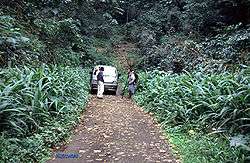
The higher slopes of the island are forested and form part of the Obo National Park, but agriculture is important near the north and east coasts. The chief exports are cocoa, coffee, copra, and palm products, while there is also a fishing industry.
Large reserves of oil are in the ocean between Nigeria and São Tomé. The discovery has been lamented by some as endangering the nation's political stability and natural environment. In response to these concerns the government of São Tomé and Príncipe has drawn up legislation in an attempt to ensure the efficient and equitable use of oil revenues over time.
Natural history
Birds
The island has a total of 63 regular bird species, plus an additional 36 vagrant and unconfirmed species. Of these, 19 are endemic and 3 near endemic; in addition, the local subspecies of olive ibis (Bostrychia olivacea bocagei) is endemic and considered critically endangered. Six species are considered vulnerable, and two critically endangered (São Tomé fiscal and São Tomé grosbeak).[1]
Towns and villages
Villages on the island include:
|
|
References
| Wikisource has the text of an 1879 American Cyclopædia article about São Tomé Island. |
Coordinates: 0°14′N 6°36′E / 0.233°N 6.600°E
| Major | |
|---|---|
| Minor | |